Image
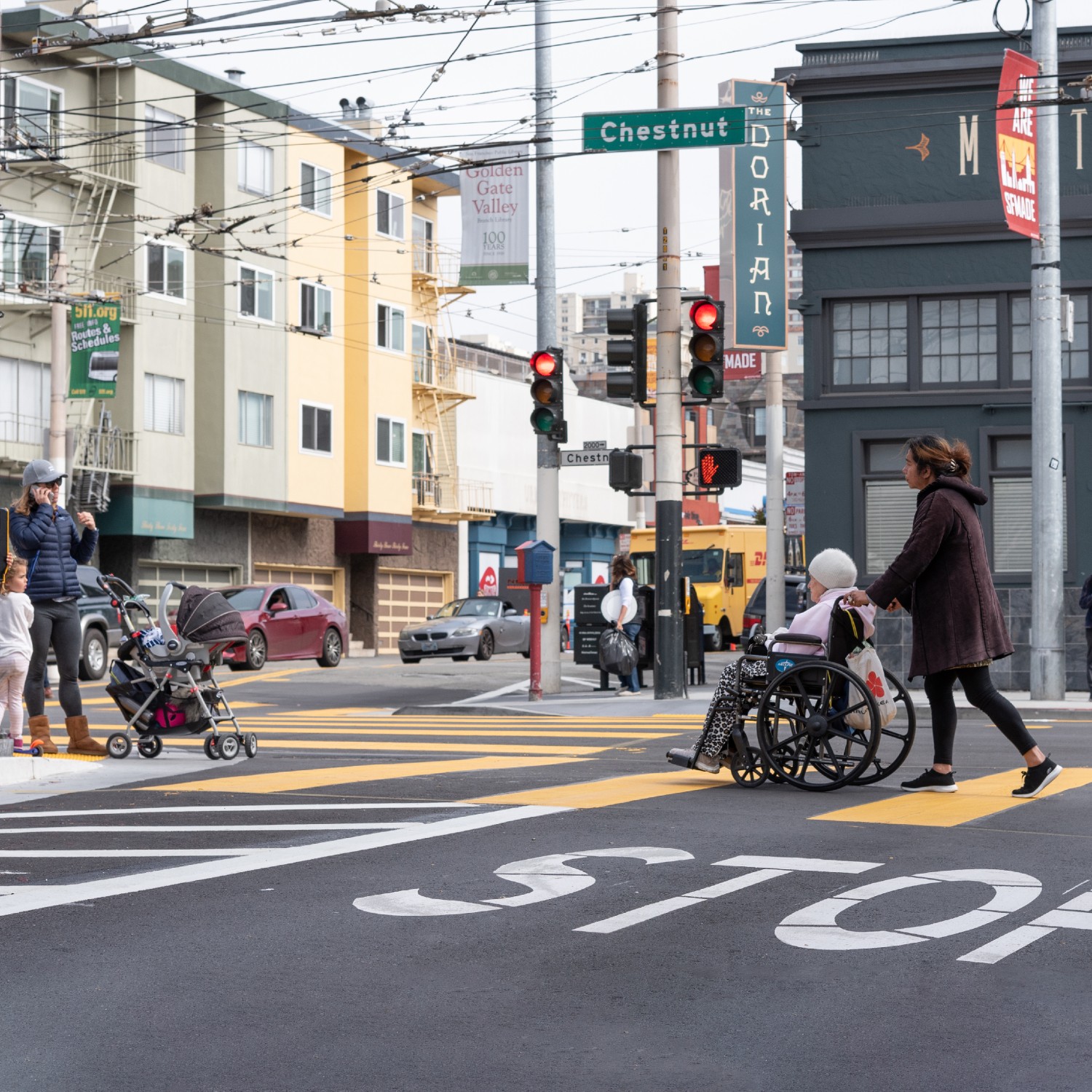

The District 2 Safety Study was completed at the request of former Transportation Authority Board Member Catherine Stefani (District 2) and funded through the San Francisco Transportation Authority’s Neighborhood Program. Transportation Authority staff collaborated with the San Francisco Municipal Transportation Agency (SFMTA) on this study.
The study focused on addressing safety challenges and barriers to access to locations that attract children, seniors, and other vulnerable road users, including parks, schools, hospitals, and recreational destinations. The goal of the study was to identify short-term, quick-build improvements near these locations that could be implemented with remaining Neighborhood Transportation Program funds from Prop K. To identify areas within the District with a high concentration of these destinations, the study team analyzed land use and transportation data and conducted a first round of community engagement to understand resident travel patterns and challenges. Using this information, the team developed a toolkit for safety improvements around select land uses, aligning specific safety treatments to different types of land uses. The study team recommends quick-build safety treatments at six locations throughout the District, with input from the second round of community engagement. These treatments are summarized below:
Quick-build improvements are reversible, adjustable traffic safety improvements that can be installed relatively quickly. Unlike major capital projects that may take years to plan, design, bid, and construct, quick-build projects can be completed within weeks or months. Improvements may include:
For more information, visit the SFMTA Vision Zero Quick-Build Program website.
The study team used land use and transportation data to understand the existing transportation access and safety conditions and identify areas within District 2 that have a high concentration of locations that draw vulnerable road users (i.e., children, seniors, and people with disabilities). This approach built off of the methodology behind a 2017 map produced by the San Francisco Department of Public Health which aimed to address safety for seniors and people with disabilities by visualizing priority areas where they live and travel and injury segments where pedestrian injuries to these populations are concentrated. For more information on the methodology, please see the Technical Appendix.
The study team identified locations that attract vulnerable road users, including schools, parks, hospitals, senior homes, libraries, and places of worship. These locations were overlaid with transportation features such as public transit routes, the local bike network, frequent paratransit pickup and drop off locations, and the High Injury Network (HIN), and Equity Priority Community (EPC) boundaries. Based on this initial map, the study team identified five clusters within District 2, with each cluster containing a combination of: 1) major destinations drawing vulnerable road users; 2) proximity to bike network and transit network connections; and 3) opportunities to support recent or planned transportation improvements for pedestrians, cyclists, and transit riders. Clusters were also selected to be spread throughout the district.
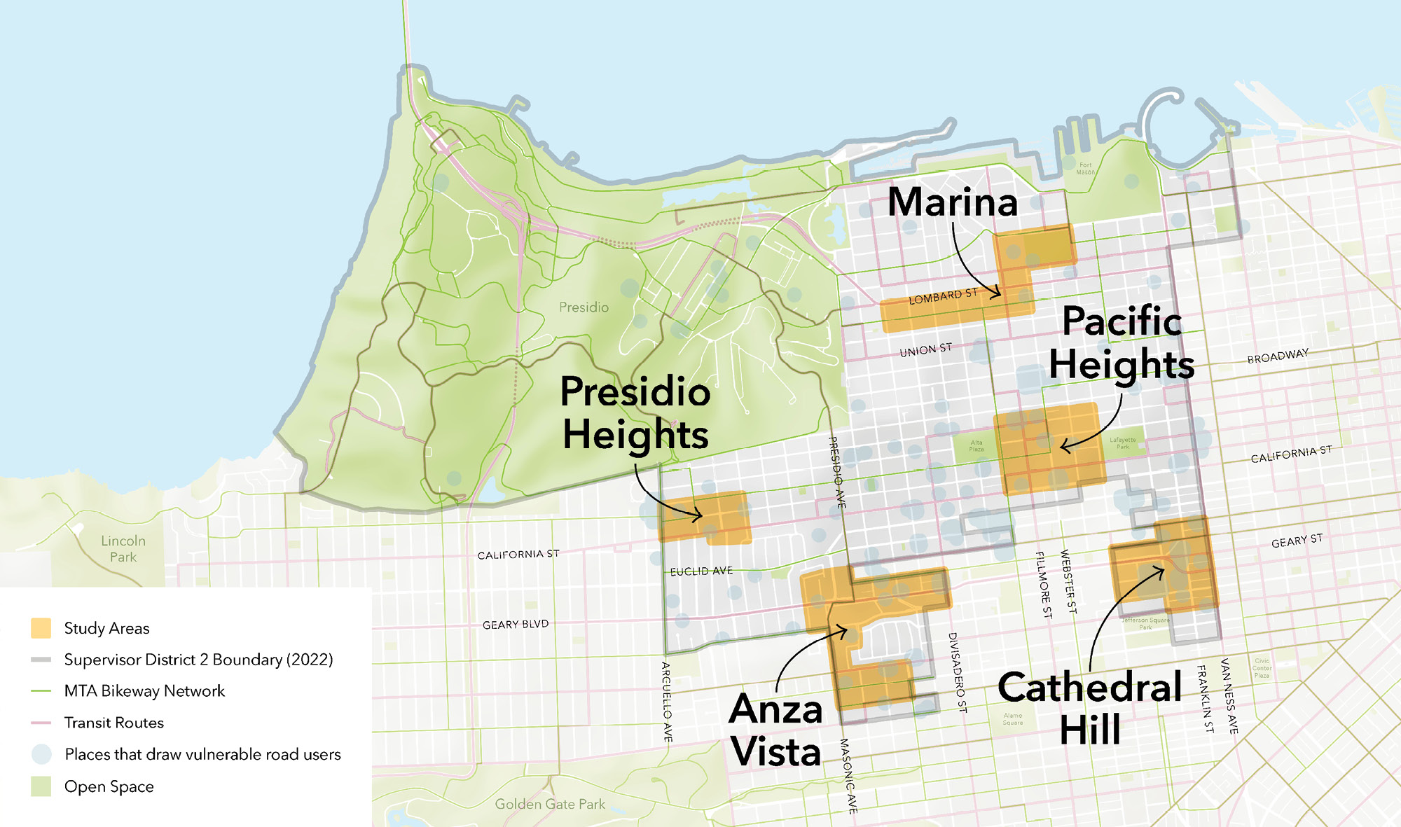
The study team conducted site visits to each of the clusters to further narrow down and identify specific study areas (shown in Figure 2-1 below). Community engagement efforts were focused on these five study areas to understand the travel patterns and safety and access challenges of residents and visitors.
To understand how District 2 residents travel around the study areas and the safety and access challenges they experience, the study team conducted community engagement in summer 2024 through both online and in-person events. Engagement included an online survey distributed through social media and newsletters, a virtual town hall with Spanish and Mandarin translation, pop up events, and presentations at community meetings. The survey was open from May to July 2024 and received 139 responses.
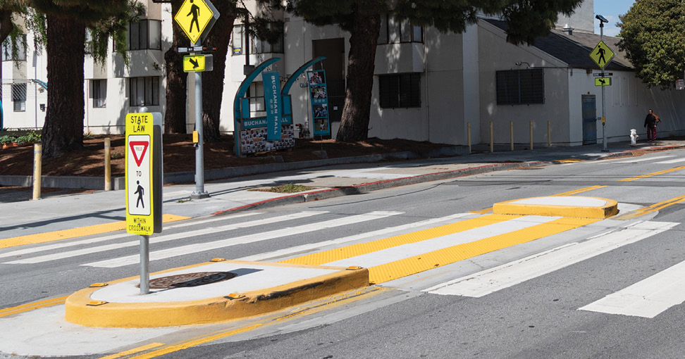
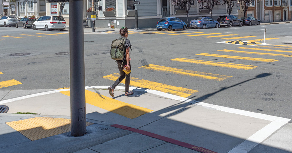
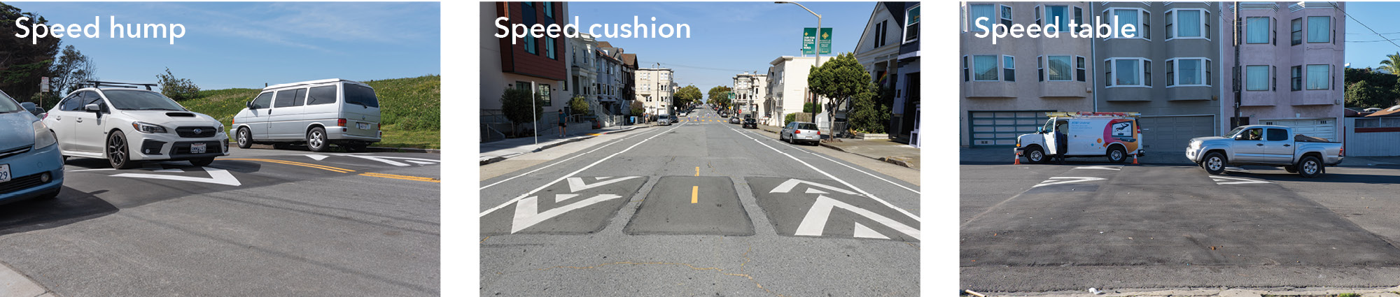
The survey asked respondents general questions about their priorities for safety and access in the District and types of places that most need safety and access improvements for vulnerable road users. The survey then asked respondents to provide feedback for one or more specific study areas. For each study area, respondents were asked about their general travel patterns, safety and access challenges, and preference for safety treatments. The safety treatments were drawn from the SFMTA’s Vision Zero Quick-Build Toolkit, shown below.
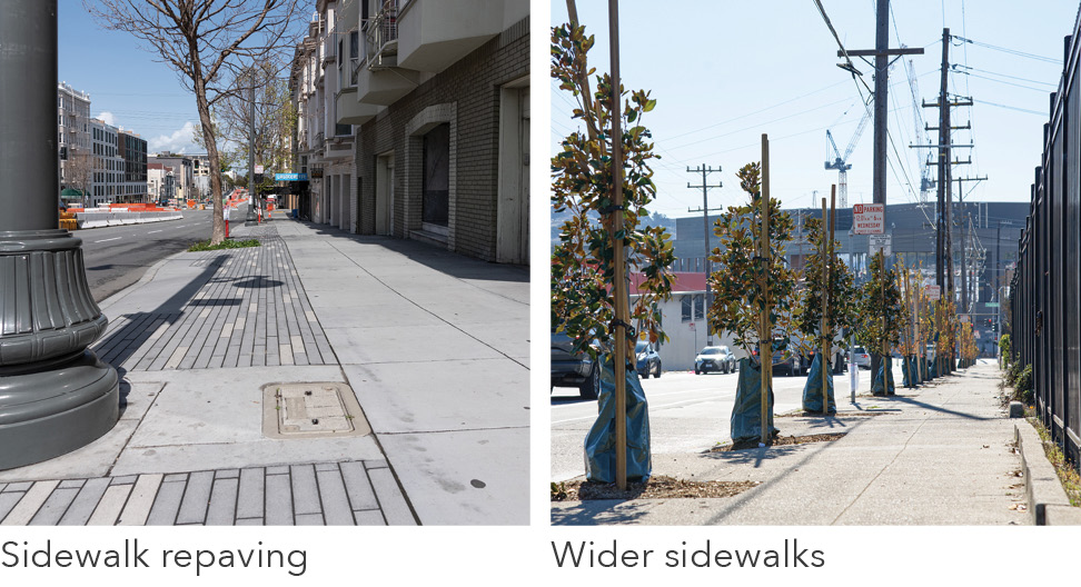
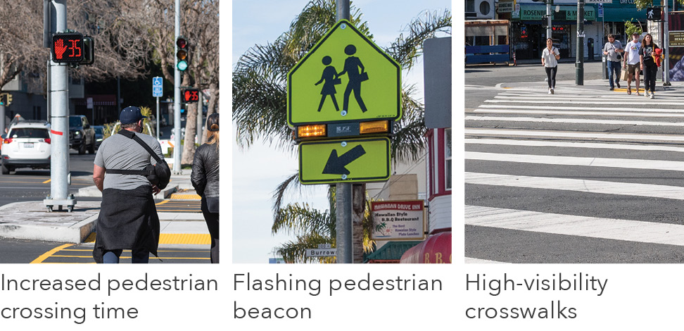
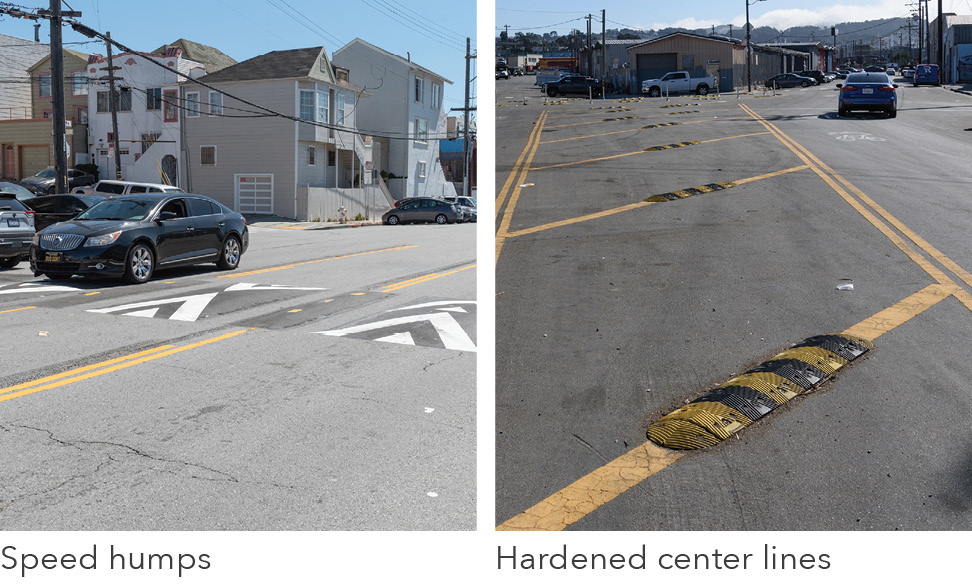
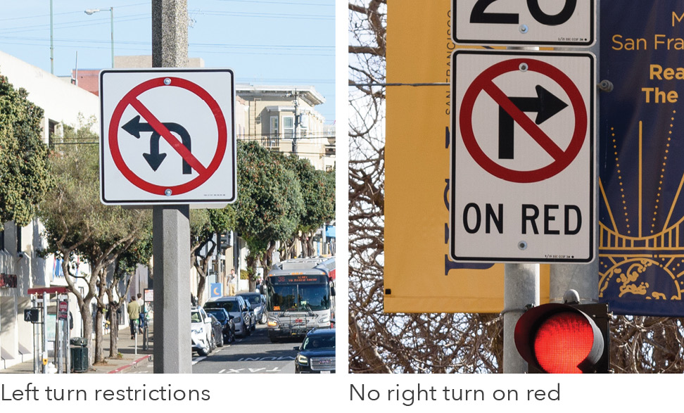
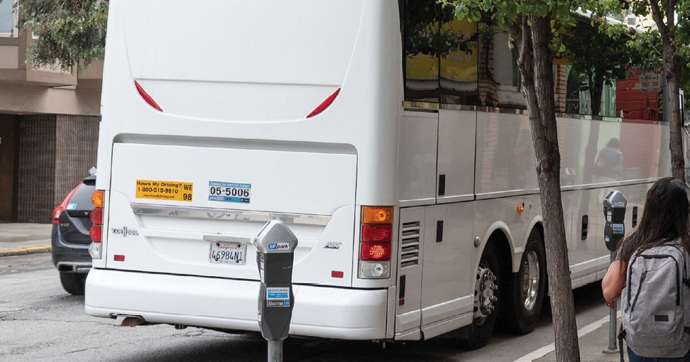
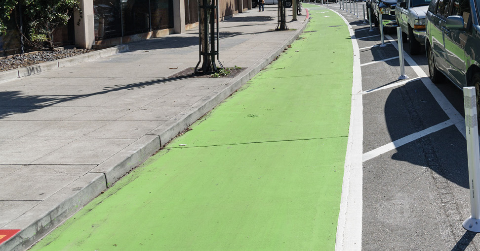
The study team held one pop up in each study area to get feedback from residents of the area or community members who travel to or within the area. Pop ups were organized near key land uses in the area. The study team held four pop up events from May to June 2024 at Marina Middle School (Marina study area), CPMC Pacific Heights (Pacific Heights study area), St. Cyprian’s Episcopal Church (Anza Vista study area), and the Presidio Branch Library (near Presidio Heights study area).
The survey received 139 responses and 138 of these responses provided home zip codes, which allowed for an approximate determination of home location of respondents in relation to district boundaries. Most respondents live in zip codes near the Marina, Pacific Heights, and Anza Vista study areas (69% of respondents), which corresponds to a higher number of survey responses providing feedback for these study areas. In comparison, fewer respondents live near the Presidio Heights and Cathedral Hill study areas (9% in each study area). There were also a small number of respondents who live outside of District 2 (less than 5%).
The study team compared the race/ethnicity, income, and age of survey respondents to the 2023 American Community Survey (ACS) Five-Year Estimates for District 2. Figure 3-10 shows a slight underrepresentation of Hispanic/Latino and Asian survey respondents and overrepresentation of Caucasian/white, Black / African American, and Native American respondents.
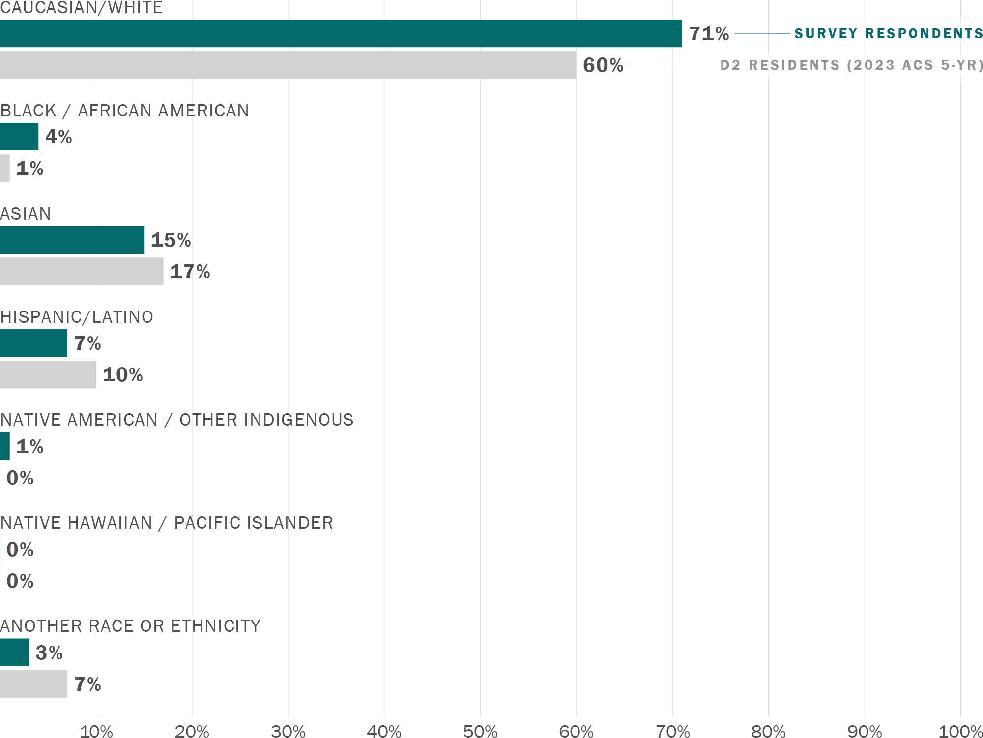
Note: chart excludes 14% of respondents who selected "Prefer not to say"
Download chart data (CSV)
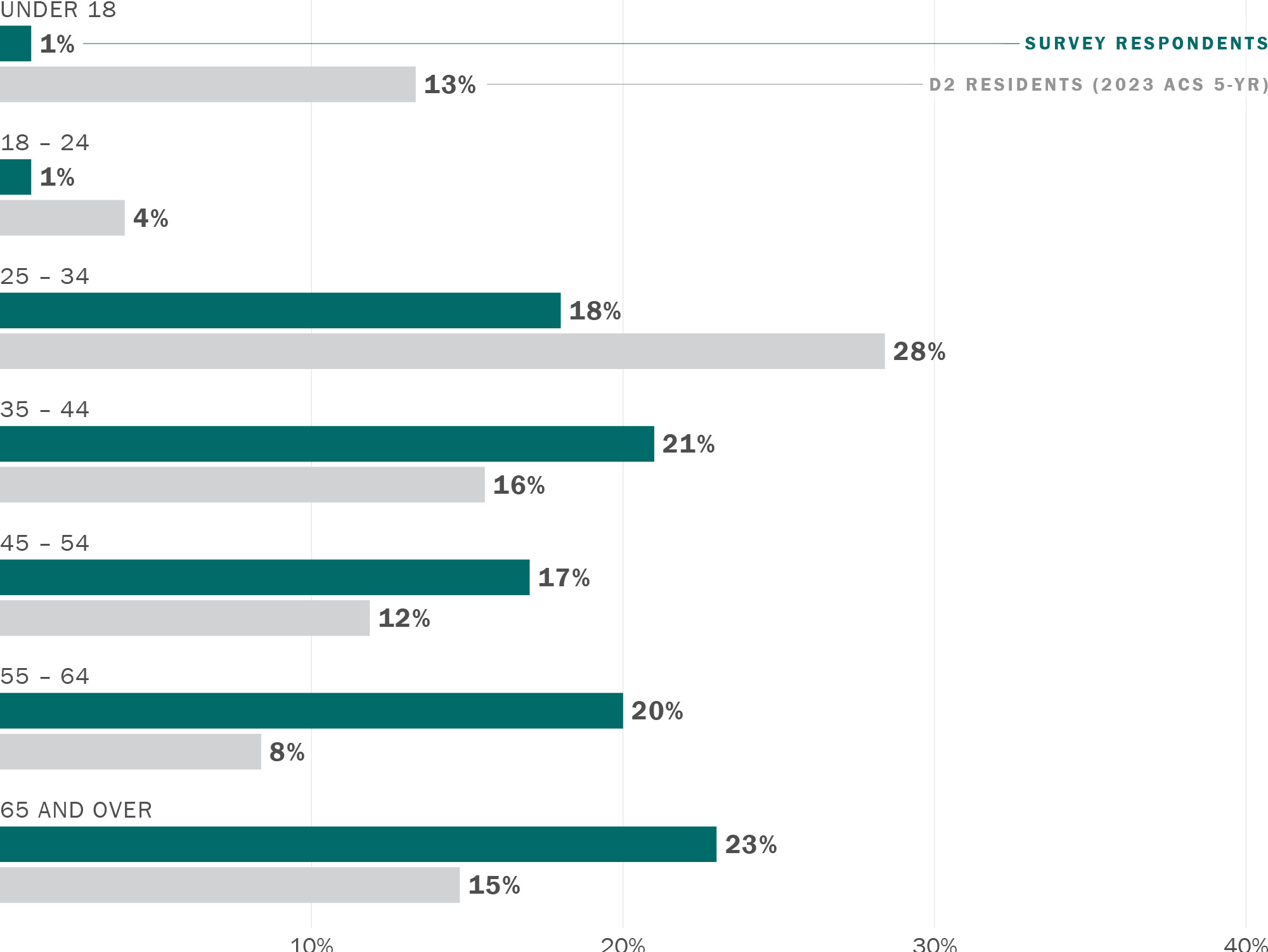
Figure 3-11 below shows that survey respondents were also older than D2 residents. There were also fewer survey respondents with children (30% of survey respondents compared to 41% of D2 residents from the 2023 ACS).
Note: chart excludes 10% of respondents who selected "Prefer not to say"
Download chart data (CSV)
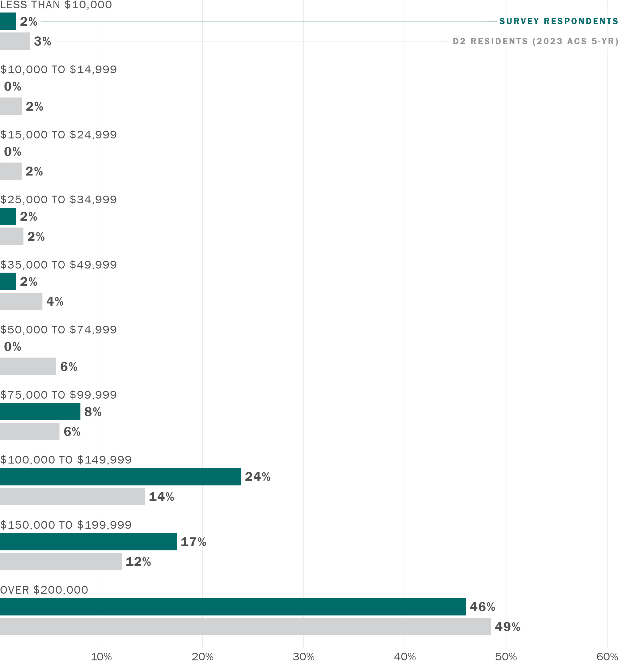
Almost half of respondents did not respond to the survey question about household income. For those who did respond, Figure 3-12 shows that households with an annual income less than $100,000 were underrepresented compared to D2 residents.
Note: chart excludes 46% of respondents who selected "Prefer not to say"
Download chart data (CSV)
In pop up events and the virtual town hall, participants emphasized the need for more traffic enforcement. Participants stated that, as pedestrians, they noticed that many drivers are distracted and not stopping at stop signs. Speeding was also a major issue in the District and participants stated that effective treatments were needed to slow down vehicle speeds.
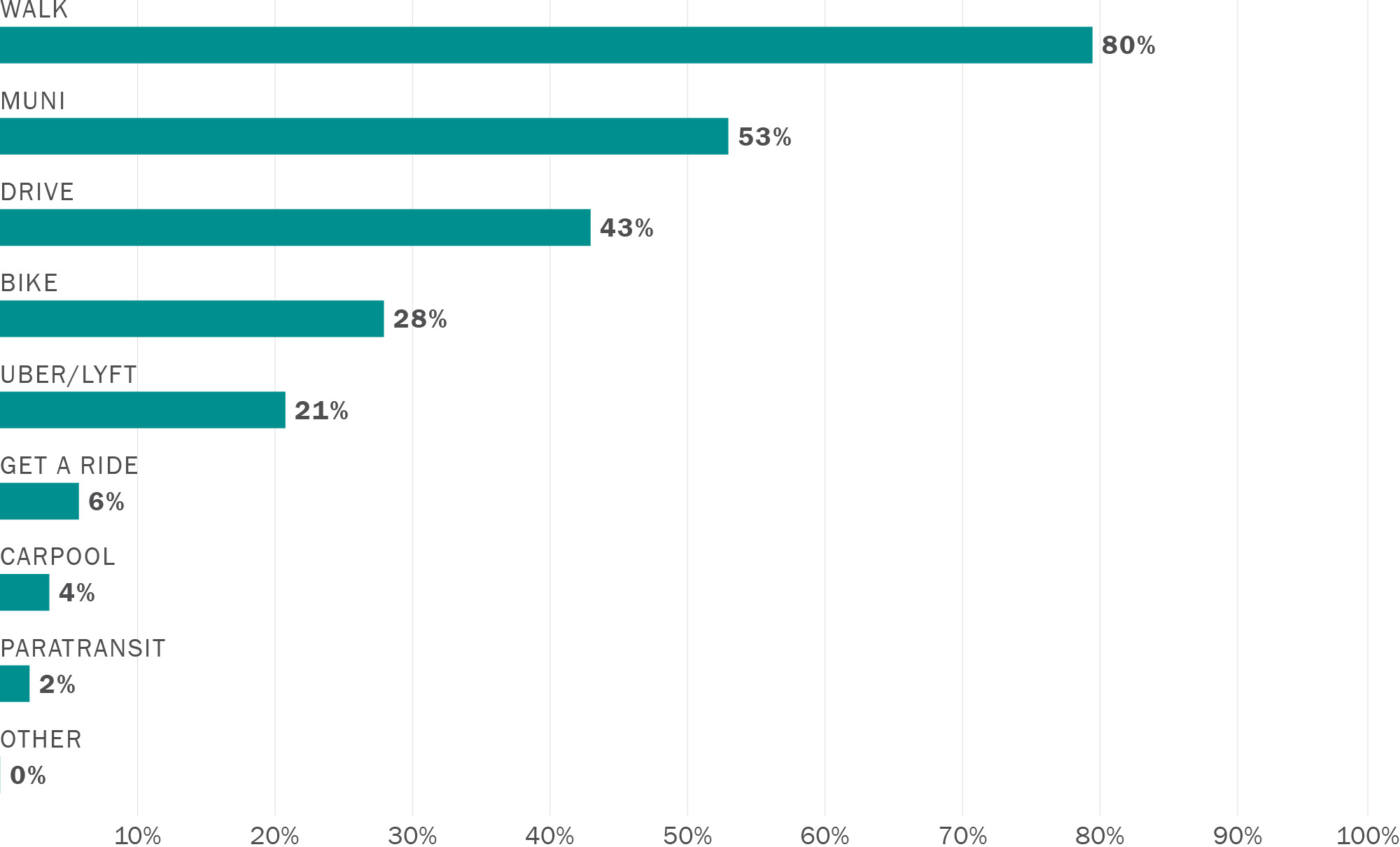
For each study area, respondents were asked to select all transportation modes they used to get around. These responses are combined across all study areas in Figure 3-13 to show how District 2 residents generally use transportation to, from, and within the study areas.
Download chart data (CSV)
Active transportation mode share was high among survey respondents. Walking was the most common transportation mode, with 80% of survey respondents saying that they walk in District 2, and 28% of survey respondents bike. More than half (53%) of respondents said they use Muni and 43% drive in District 2.
To understand overall priorities for safety and access in District 2, survey respondents were asked to select up to three types of places that most need safety and access improvements for vulnerable road users. The top two responses were parks or open spaces (51% of respondents selected) and schools, daycares, and nurseries (47% of respondents selected), followed by senior centers and eldercare facilities (34%) and hospitals and other healthcare services (32%). Libraries (19%) and churches, synagogues and other places of worship (4%) were not selected by as many respondents.
The survey asked respondents to provide feedback on transportation challenges and preferences for safety treatments for as many of the study areas as they would like. Across all study areas, speeding and traffic violations (e.g., violating no right turn on red, ignoring stop signs, etc.) and lack of traffic enforcement were identified as major safety challenges. Each of the study areas also had unique safety challenges and preferences, which are summarized in the next sections. Specific locations with safety challenges were identified through open-ended comments in the survey, stickers placed on a map of the study area at pop up events, and verbal comments from attendees. These locations and challenges are summarized in a table for each study area.
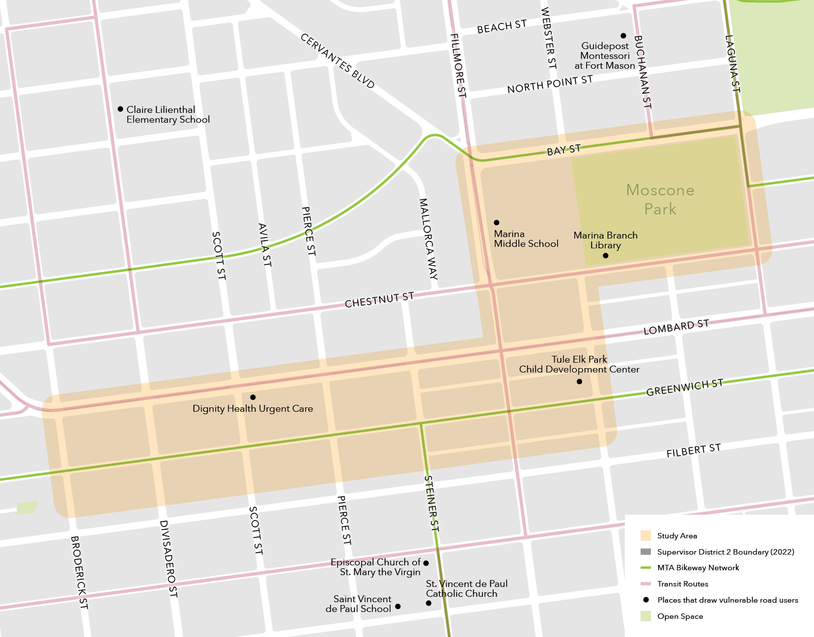
The Marina study area, shown in Figure 3-14, is located in the northern part of the district and includes Marina Middle School, the Marina Branch Library, and the Moscone park area. The study area also includes a segment of Lombard Avenue that has been identified as part of the High Injury Network by the San Francisco Department of Public Health. There are some wider streets (e.g., Bay Street, Lombard Street) that have medians for traffic calming.
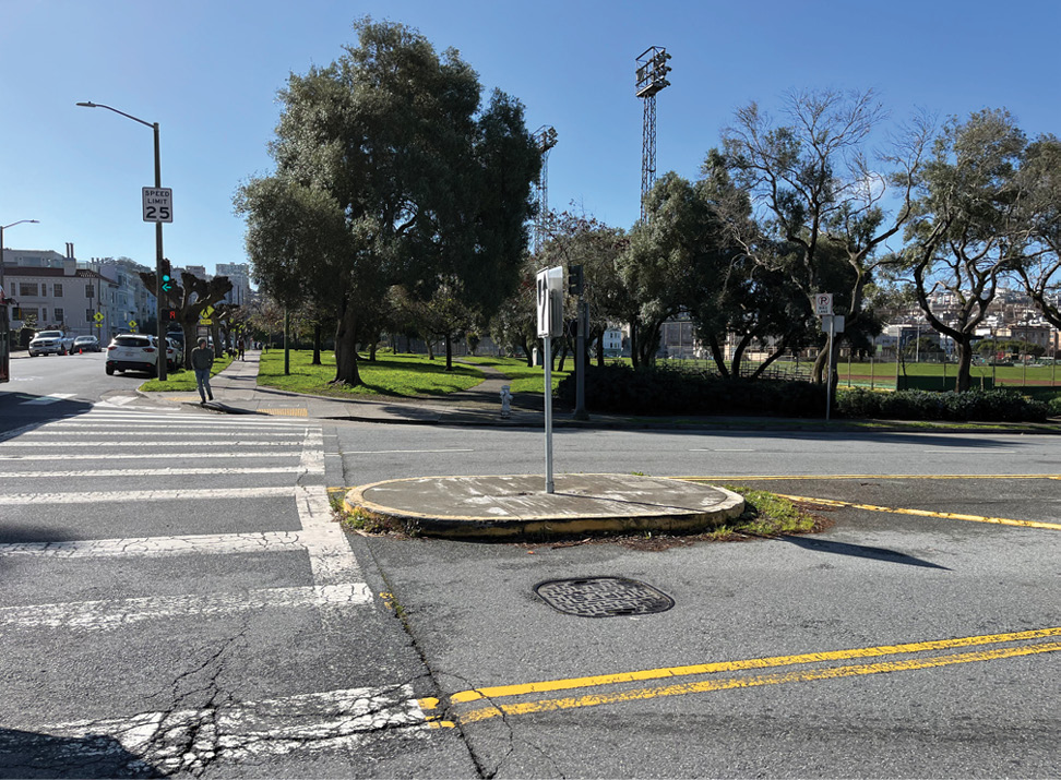
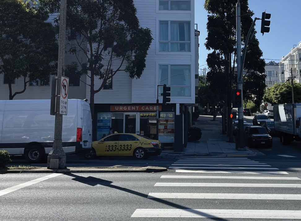
In the survey, 61 respondents gave feedback for the Marina study area. Transportation Authority staff held one pop up event at Marina Middle School on May 17, 2024 during school drop-off to engage with students and parents. The top responses for key survey questions are outlined below, along with a summary of main feedback received at in-person events.
What are some of the main reasons you travel to this area?
How do you usually get to this area?
What are some of the safety and access challenges you experience in this area?
Other public comments mentioned the lack of traffic enforcement for double parking and drivers not stopping at stop signs. Bikes, scooters, and delivery drivers using the sidewalk was also a major concern in the Chestnut Street commercial area.
What types of safety treatments would you like to see in this area?
Attendees of the pop-up event also preferred traffic signal improvements and bike improvements.
Survey respondents and attendees of in-person events identified specific locations in the Marina study area that have safety and access challenges. Table 3-1 summarizes these locations, nearby land uses that attract vulnerable road users, and safety and access challenges.
For many locations in this study area, respondents stated that poor lighting conditions and narrow sidewalks were main challenges. These are issues that cannot be addressed with the quick-build toolkit, but can be addressed through alternate funding sources in longer term work.
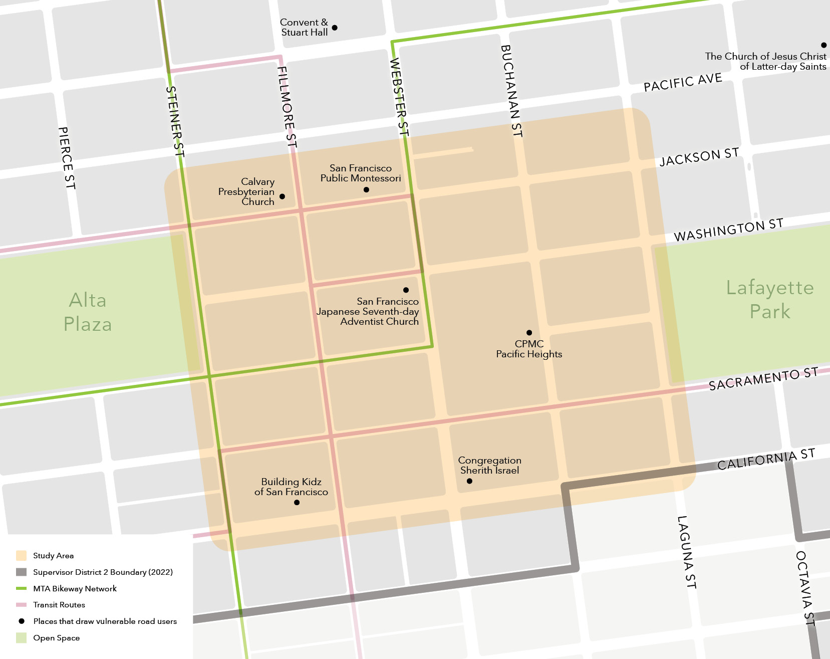
The Pacific Heights study area, shown in Figure 3-17, contains two parks (Alta Plaza and Lafayette Park), a medical center (the CPMC Pacific Heights campus), and a number of schools, daycares, and places of worship. The study area is fairly hilly, and both Alta Plaza and the CPMC Pacific Heights campus are located at the top of streets with a steep grade. A portion of Clay Street south of Alta Plaza is part of the SFMTA Slow Streets Program, which aims to expand the active transportation network through low vehicle volume and speed streets that are safe and comfortable for biking, walking, and rolling.
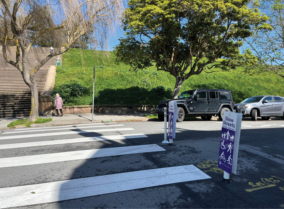
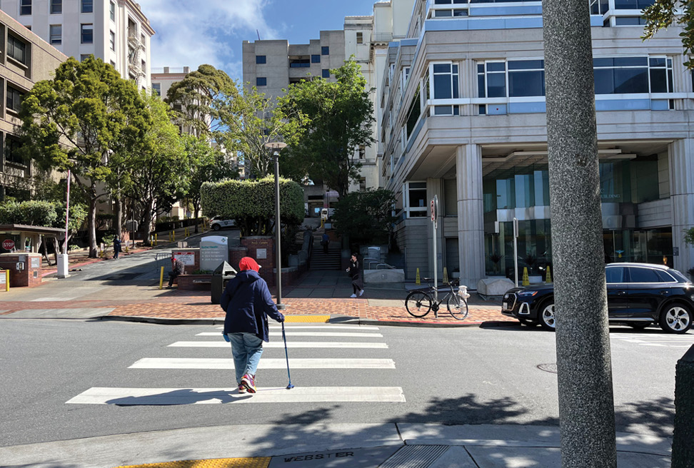
In the survey, 45 respondents gave feedback for the Pacific Heights study area. Transportation Authority staff also held one pop up event outside of the CPMC Pacific Heights campus on June 27, 2024 to engage with CPMC patients, workers, and community members. The top responses for key survey questions are outlined below, along with a summary of main feedback received at in-person events.
What are some of the main reasons you travel to this area?
How do you usually get to this area?
What are some of the safety and access challenges you experience in this area?
Other comments mentioned dangerous driver behavior and lack of traffic enforcement as major issues. Comments also mentioned a lack of safe bike infrastructure in the study area. With about a quarter of survey respondents in Pacific Heights saying that they bike in the area, these comments highlight the demand for improvements to existing bike infrastructure in Pacific Heights.
What types of safety treatments would you like to see in this area?
During the outreach process, survey respondents and attendees of in-person events identified specific locations in the Pacific Heights study area that have safety and access challenges. Table 3-2 summarizes the locations, nearby land uses that attract vulnerable road users, and the safety and access challenges that residents or visitors experience at these locations.
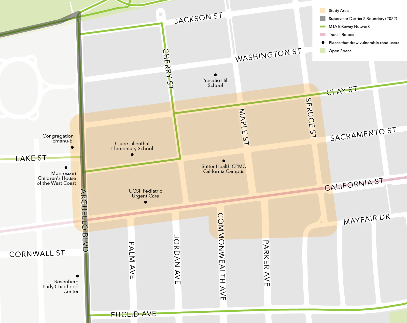
The Presidio Heights study area contains two elementary schools, a pediatric urgent care facility, and a Sutter Health CPMC location. The CPMC campus is now closed and will be developed into housing. The proposed development will include nearly 500 residential units, as well as additional units for assisted living and memory care. A portion of Clay Street on the eastern side of the study area is part of the SFMTA Slow Streets Program. This study area has some traffic calming measures, such as concrete bollards to enforce daylighting at certain corners.
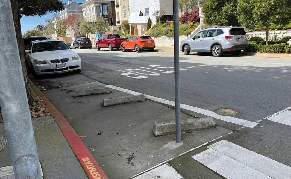
Twenty-seven survey respondents gave feedback for the Presidio Heights study area. Transportation Authority staff held a pop up event at the Presidio Branch Library on May 30, 2024, a few blocks east of the study area, to engage with residents and visitors in the neighborhood. The top responses for key survey questions are outlined below, along with a summary of main feedback received at in-person events.
What are some of the main reasons you travel to this area?
How do you usually get to this area?
Compared to other study areas, Presidio Heights had a higher driving and bike mode share.
What are some of the safety and access challenges you experience in this area?
Similar to other study areas, many survey comments mentioned dangerous and aggressive driver behavior and lack of traffic enforcement (e.g., running red lights or stop signs, speeding) as major issues.
What types of safety treatments would you like to see in this area?
During the outreach process, survey respondents and attendees of in-person events identified specific locations in Presidio Heights that have safety and access challenges. Table 3-3 summarizes the locations, nearby land uses that attract vulnerable road users, and the safety and access challenges that residents or visitors experience at these locations.
Other responses in the survey mentioned that sidewalks on Baker Street (east of the study area) have uneven pavement, resulting in many seniors tripping. Respondents also stated that crossing times near schools were too short for pedestrians traveling with strollers and bags.
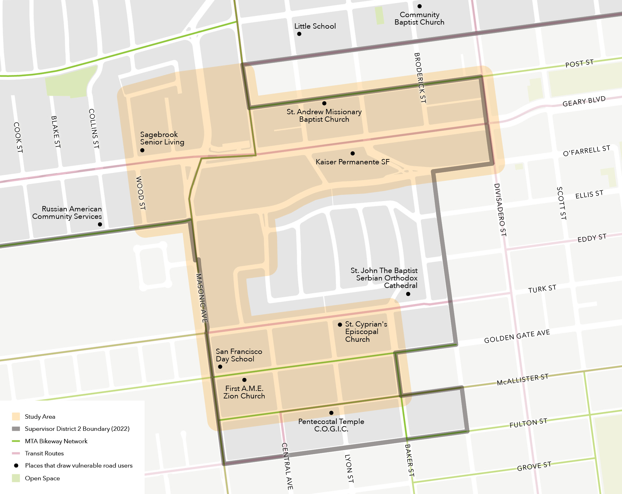
The Anza Vista study area contains the Kaiser Permanente San Francisco Medical Center, Sagebrook Senior Living, San Francisco Day School, and a number of places of worship. There are two designated Slow Streets in the southern half of the study area (Golden Gate Avenue and Lyon Street). The eastern edge of the study area overlaps with EPCs in Japantown and Western Addition.
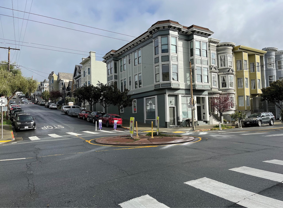
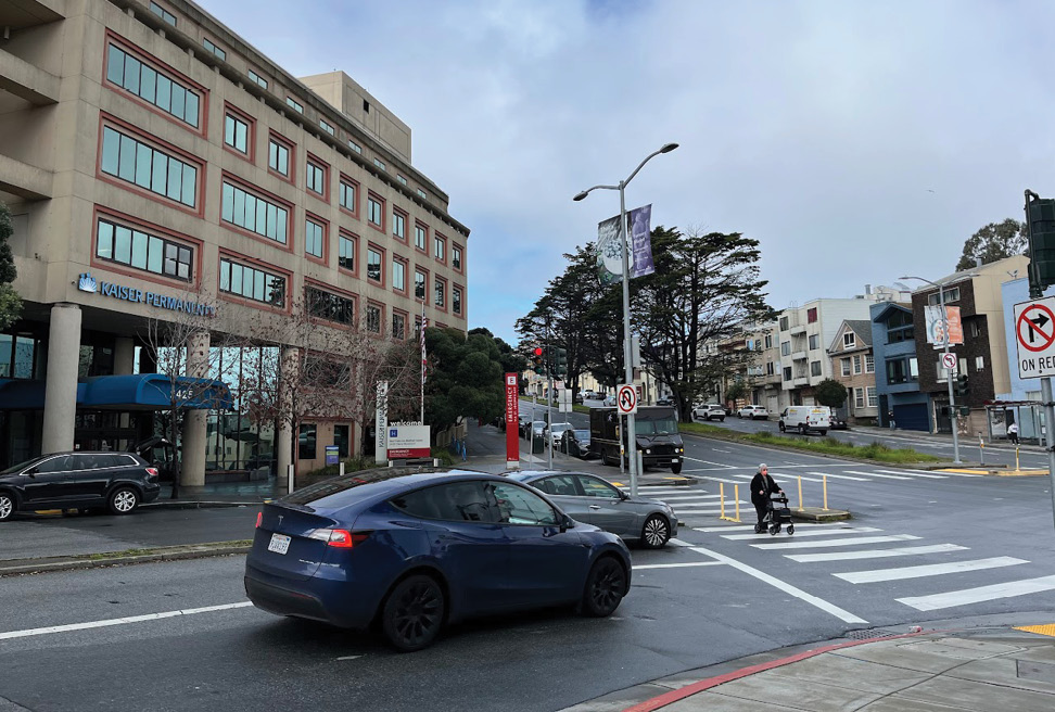
The Anza Vista study area received 40 survey responses. Transportation Authority staff held a pop up event at St. Cyprian’s Episcopal Church on Saturday, June 22, 2024 to engage with residents and visitors in the neighborhood. The top responses for key survey questions are outlined below, along with a summary of main feedback received at in-person events.
What are some of the main reasons you travel to this area?
Grocery shopping was the top trip purpose in this area. There are two large grocery stores (Trader Joe’s and Lucky), and a Target in the study area.
How do you usually get to this area?
Compared to other study areas, Anza Vista had a higher driving mode share. Although biking was not in the top three modes used, the mode share was still higher relative to other study areas (33% of respondents bike in this area).
What are some of the safety and access challenges you experience in this area?
Other survey comments mentioned aggressive drivers and challenges for cyclists (e.g., insufficient bike infrastructure, feeling unsafe while biking).
What types of safety treatments would you like to see in this area?
During the outreach process, survey respondents and attendees of in-person events identified specific locations in Anza Vista that have safety and access challenges. Table 3-4 summarizes the locations, nearby land uses that attract vulnerable road users, and the safety and access challenges that residents or visitors experience at these locations.
Most of the comment responses in the survey referred to the area near the intersection of Masonic Ave and Geary Blvd. Although location #7 (the residential area of Anza Vista) was not in the original study area, the location received multiple survey comments regarding speeding and pedestrian safety issues. For this reason, the study team decided to include the location in the list of potential places to receive safety treatments.
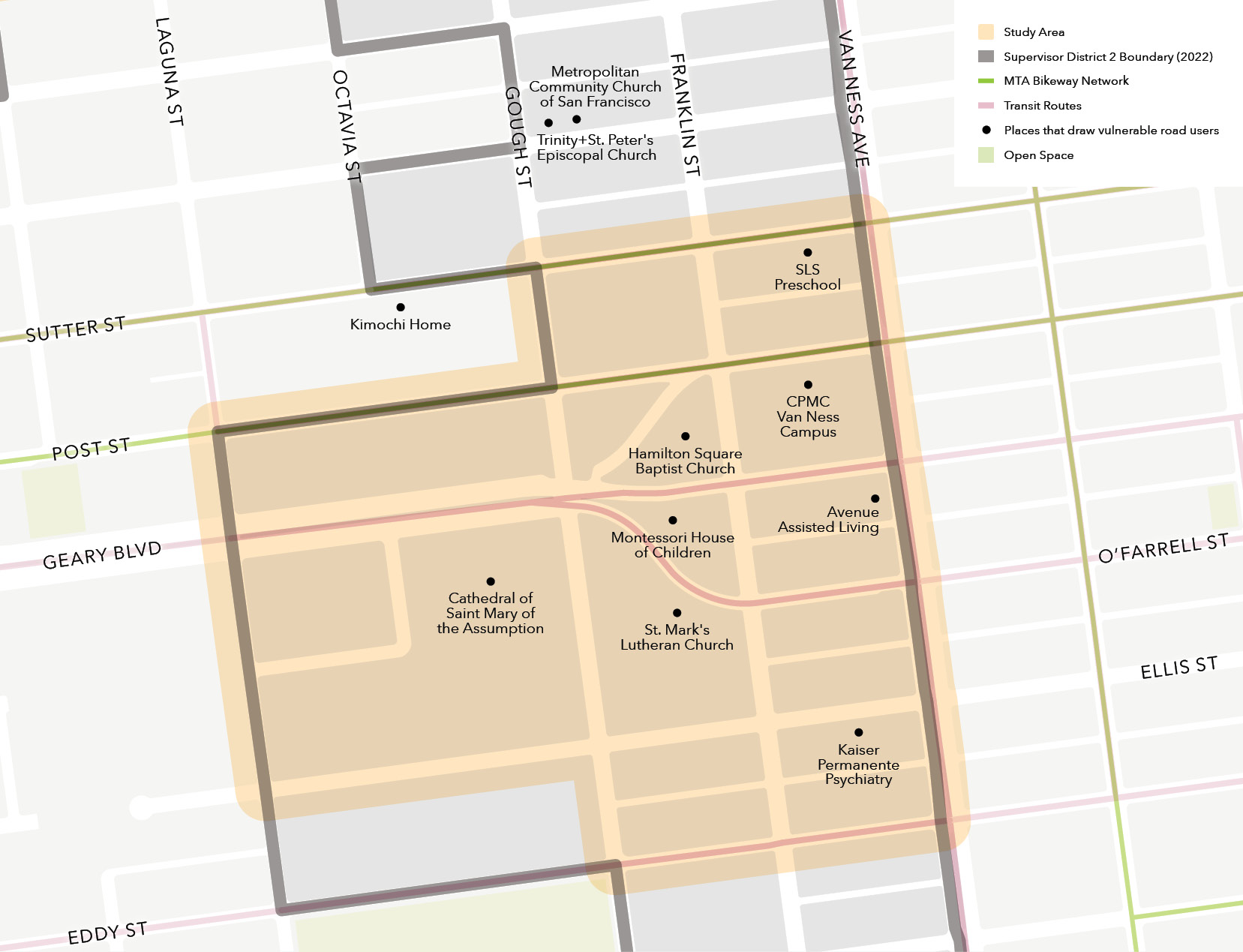
The Cathedral Hill study area contains the CPMC Van Ness campus, some large places of worship, including the Cathedral of Saint Mary of the Assumption, a preschool and a Montessori school. This study area overlaps with EPCs in Japantown and Western Addition.
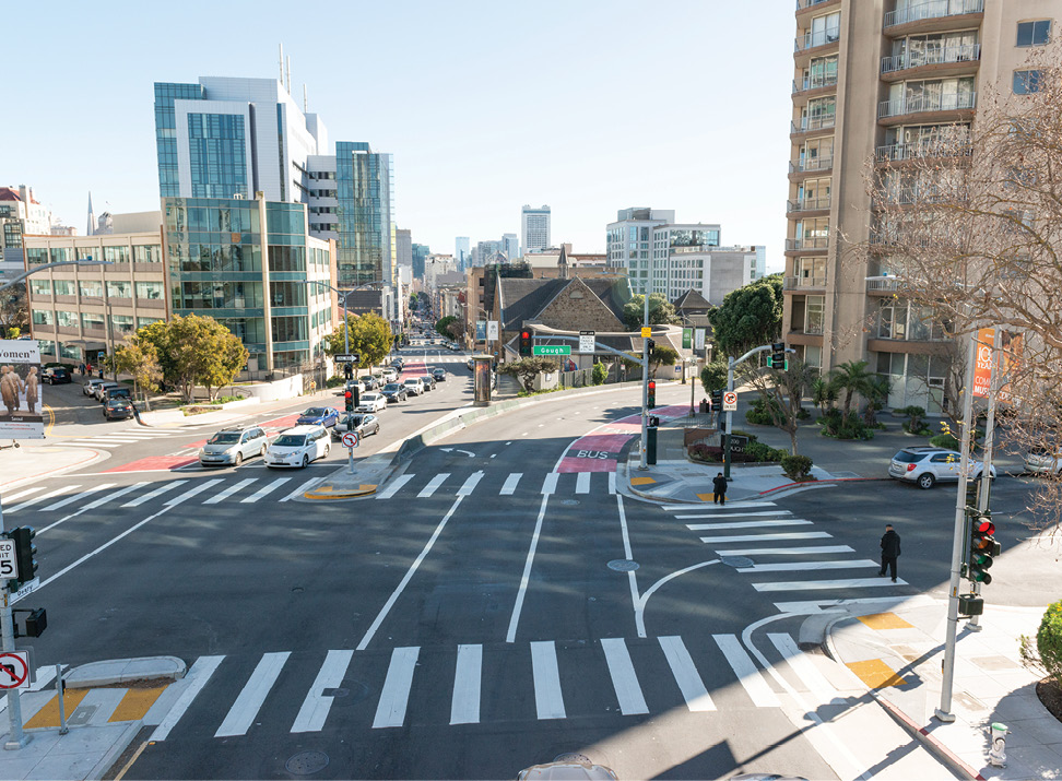
Twenty respondents gave feedback for the Cathedral Hill study area. The top responses for key survey questions are outlined below.
What are some of the main reasons you travel to this area?
How do you usually get to this area?
Cathedral Hill had the highest bike mode share of all the study areas. This is also the only study area where driving was not one of the top three modes used.
What are some of the safety and access challenges you experience in this area?
Other survey comments mentioned aggressive drivers and lack of bike infrastructure.
What types of safety treatments would you like to see in this area?
During the outreach process, survey respondents identified specific locations in Cathedral Hill that have safety and access challenges. Table 3-5 summarizes the locations, nearby land uses that attract vulnerable road users, and the safety and access challenges that residents or visitors experience at these locations.
Compared to other study areas, Cathedral Hill did not receive as many survey responses and there were fewer specific locations identified that needed safety treatments. One of the safety challenges, the narrow sidewalk on Franklin Street, cannot be addressed using the quick-build toolkit.
The study team used the safety and access challenges identified in the survey combined with feedback on preferred treatment types to make a proposal for locations that most need safety and access improvements for further detailed design and implementation. The study team developed a set of proposed quick-build treatments that could be implemented in the near-term with the budget of $430,000 in remaining NTP capital funds. For some locations, the study team also identified a pipeline of additional improvements and community ideas for other projects that could be implemented in the future with more funding.
The study team was also interested in whether there was any relationship between types of land uses (e.g., parks, schools, medical centers, etc.) and respondents’ preference for safety treatments, across the district as a whole. In general, there was no correlation since respondents’ preferred treatments were similar throughout the district. For example, speeding was a major issue raised by respondents in every study area and traffic calming measures such as speed humps were the most popular safety treatment to address speeding.
However, the study team did find some interesting patterns that could be explored in other districts in San Francisco:
The project team selected priority locations for safety and access improvements based community interest and feedback, feasibility of addressing challenges with the quick-build toolkit, and the safety priorities identified by survey respondents. These proposals are summarized in Table 4-1 below. Near-term treatments will be implemented as a next phase of this project. Medium- and long-term treatments are not in the quick-build toolkit and will require additional study and funding.
While the residential area of Anza Vista was not in one of the original five study areas, there were many survey comments about speeding being a major issue in this neighborhood, so this location was added to the list of proposed locations and treatments.
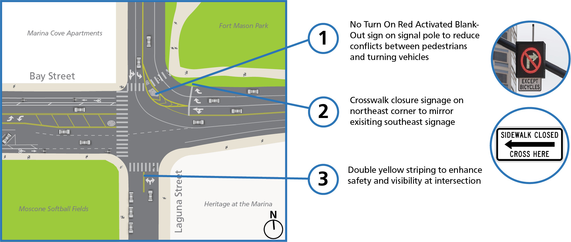
The Laguna Street/Bay Street intersection in the Marina study area provides access to Marina Middle School and Moscone Park. The main safety challenge identified through community engagement was that drivers frequently violate the “no right on red” sign turning from westbound Bay Street to northbound Laguna Street. This affects pedestrians crossing Laguna Street on the north side of the intersection.
The study team’s near-term proposals for the Laguna Street/Bay Street intersection build on SFMTA’s ongoing Vision Zero program improvements to the High-Injury Network and other nearby projects. Elsewhere in the Marina neighborhood, there are seven intersections on the high-injury network that are receiving improvements as part of SFMTA’s Vision Zero Quick-Build Toolkit program. This includes six intersections along Greenwich Street from Broderick Street to Fillmore Street, and at the intersection of Broderick Street and Lombard Street. In October 2024, SFMTA activated a new pedestrian signal head at Bay Street and Laguna Street and added Lead Pedestrian Intervals at signals on Bay Street from Laguna Street to Stockton Street as part of the Vision Zero Signal Retiming Project. There is also a bulb-out planned at the southeast corner of the intersection as part of a redevelopment project.
The study team’s near-term proposal is to increase the visibility of pedestrians and cyclists at this crossing. A blank out LED “No Right Turn” sign is recommended to increase compliance with the no right on red restriction for drivers turning from westbound Bay Street onto northbound Laguna Street. Blank out signs use LEDs to make signs more noticeable to drivers and are more visible in any light or weather conditions. Other near-term recommendations include adding pedestrian warning signs, adding crosswalk closure signage on the southeast corner to clarify the existing prohibited crosswalk at the northeast corner of the intersection, and double yellow striping on the south side of the intersection to help with turning movements onto Laguna Street.
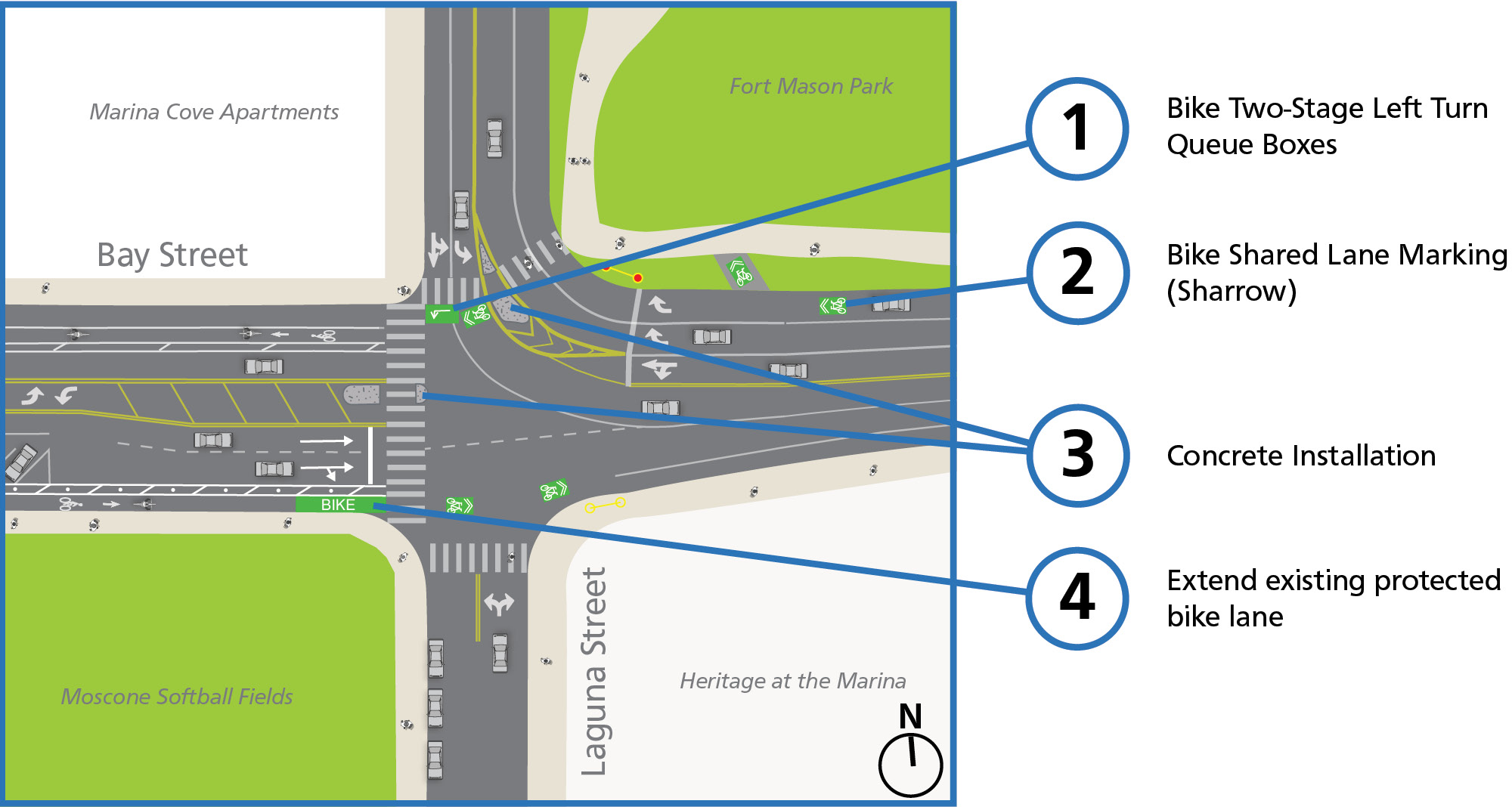
The study team identified several potential long-term cyclist and pedestrian improvements. Through video observations, the study team found that cyclists were traveling on westbound Bay Street, where there is no bike path, and parallel to an existing bike path in Fort Mason Park. A potential long-term improvement could add sharrow markings on Bay Street to increase cyclist visibility and add a mid-block bike ramp connecting Bay Street to the existing bike path in Fort Mason. This can help cyclists more easily access the existing bike path. Another potential long-term improvement is reconstructing the median island on the crosswalk on the north side of Laguna Street with a wider opening, aligned with the width of the crosswalk, which could allow cyclists to more easily use the crosswalk to connect between the Fort Mason bike path and the bike lane on the west side of the intersection.
The study team also observed that the existing protected eastbound bike lane on Bay Street could be extended until the intersection to reduce conflicts between cyclists and vehicles turning right from Bay Street onto Laguna Street. This recommendation could be combined with reconstructing the median island and realigning the eastbound Bay Street traffic lanes to provide more space for the bike lane and for turning vehicles.
In the long-term, the study team recommends studying a full intersection redesign with SFMTA which could include reallocating or realigning travel lanes, bikeway and signal upgrades, new crosswalks, and pedestrian refuge islands. Nearby segments of Bay Street (from Octavia to the Embarcadero) are on the Vision Zero High Injury Network. Laguna Street from Bay Street to Francisco Street is included in the North Star Network of SFMTA’s Biking and Rolling Plan, with the recommendation to upgrade the existing facility to a fully traffic calmed, shared street. The intersection study can be coordinated with a parallel effort evaluating the feasibility of a new bikeway through Fort Mason to improve access and safety. This bikeway concept is part of a broader National Park Service-led study. The proposed alignment would connect cyclists between the Bay/Laguna intersection and the Bay/Van Ness intersection. The long-term Bay/Laguna intersection study could incorporate design measures to improve bicycle movements through the intersection and strengthen connections to the proposed Fort Mason bikeway.
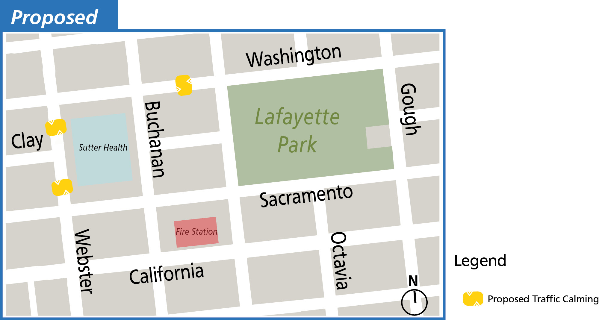
Two locations in the Pacific Heights study area were identified as locations with high traffic speeds: the Clay Street/Webster Street intersection, which provides access to the CPMC Pacific Heights campus, and the segment of Washington Street west of Lafayette Park. Community members also noted pedestrian conflicts for those crossing Webster Street to get from the parking garage to the medical center. Site observations by the study team showed that double parking contributed to pedestrian visibility challenges. SFMTA has implemented recent improvements at this intersection, including repainting crosswalks and new concrete bulb-outs.
The study team’s near-term recommendation is to install traffic calming devices on Webster Street from Sacramento Street to Washington Street, and on Washington Street from Buchanan Street to Laguna Street. To address double parking issues, the SFMTA will study and implement color curb changes to better balance space for goods and passenger loading near the Clay/Webster intersection.
* The exact type and number of traffic calming devices will be determined in the detailed design phase.
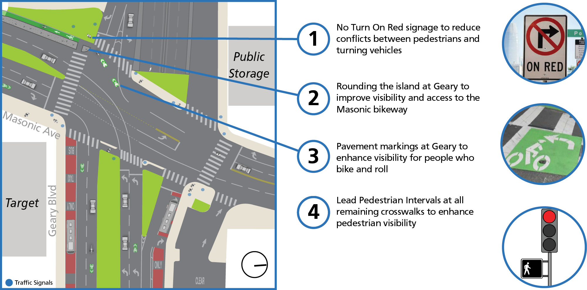
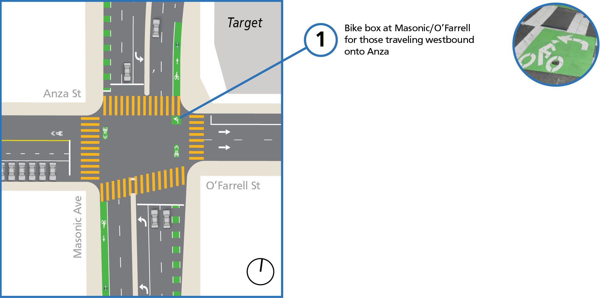
Masonic Ave/Geary Blvd is a major intersection with a mixture of car, pedestrian, and cyclist traffic, in addition to the 38, 38R, and 43 Muni lines. Nearby attractions include grocery stores (Trader Joe’s and Target), the Kaiser Permanente San Francisco campus, and the University of San Francisco campus. The study team heard feedback about pedestrian and cyclist visibility challenges and cyclist wayfinding challenges near this intersection. In particular, cyclists had difficulty navigating to the bike lane entrance on Masonic Ave on the south side of the intersection, and completing the left turn from Masonic Ave onto Anza St.
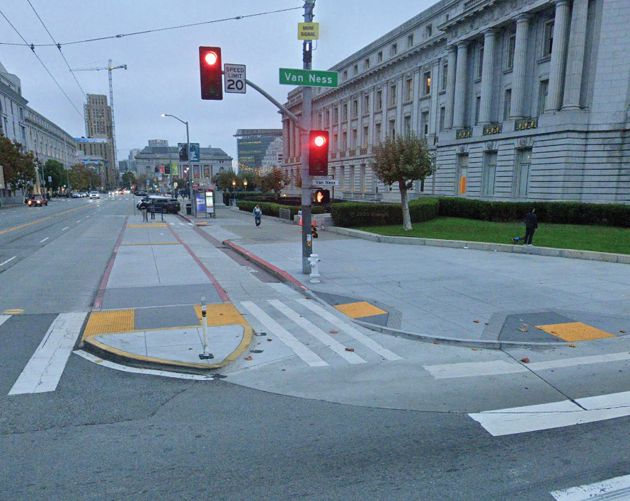
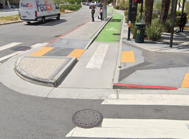
Near-term recommendations include: 1) No Turn on Red signage to reduce conflicts between pedestrians and turning vehicles; 2) rounding the concrete island nose at Geary Blvd to improve visibility and access to the Masonic bikeway; 3) additional pavement markings on Geary Blvd to enhance visibility for people who bike and roll; 4) a bike box at Masonic/O’Farrell for those traveling westbound onto Anza; and 5) Lead Pedestrian Intervals at all remaining crosswalks to enhance pedestrian visibility.
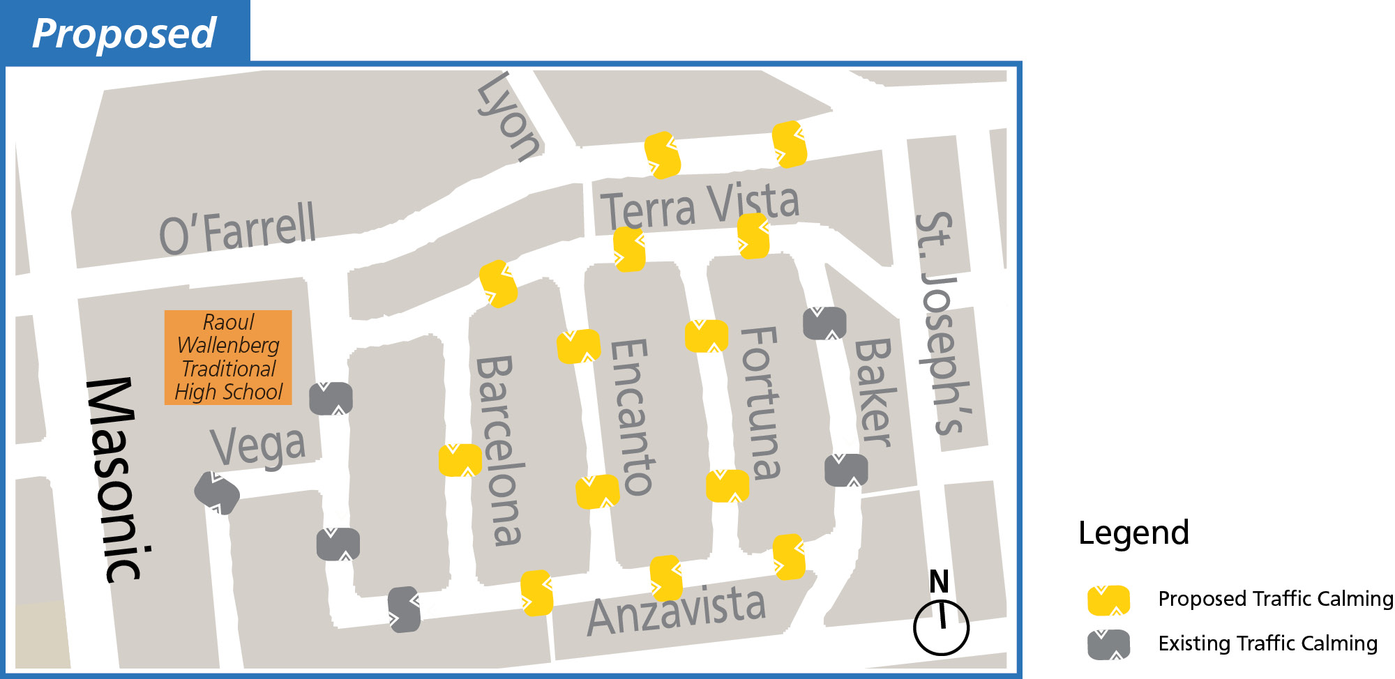
This residential area of Anza Vista has access to shopping and schools. The study team received comments about high vehicle speeds and cut-through traffic on several streets in this area. SFMTA recently implemented a road diet on O’Farrell Street from Masonic Avenue to St. Joseph’s Avenue using pavement markings and striping. To further address speeding, the study team’s near-term recommendation is to install traffic calming measures on Anzavista Avenue, Barcelona Avenue, Encanto Avenue, Fortuna Avenue, Terra Vista Avenue, and O’Farrell Street.
Feedback from the Presidio Heights study area, where there is a high bike mode share, showed a strong community desire for bike improvements and bike parking. Prior outreach efforts in the city have found that bike theft is a concern and lack of secure bike parking locations is a barrier to bike use. In Presidio Heights, the study team is recommending bike parking locations to support planned improvements to bike infrastructure on Arguello Boulevard through the SFMTA-led Arguello Safety Project. The Arguello Safety Project may also implement other quick-build safety improvements to address issues of active transportation safety.
In the medium-term, the study team recommends exploring locations for short- and long-term secure bike parking. Bike parking could be located at daylighting sites, taking advantage of free curb space and helping reinforce parking restrictions near crosswalks to improve the visibility of people crossing the street.
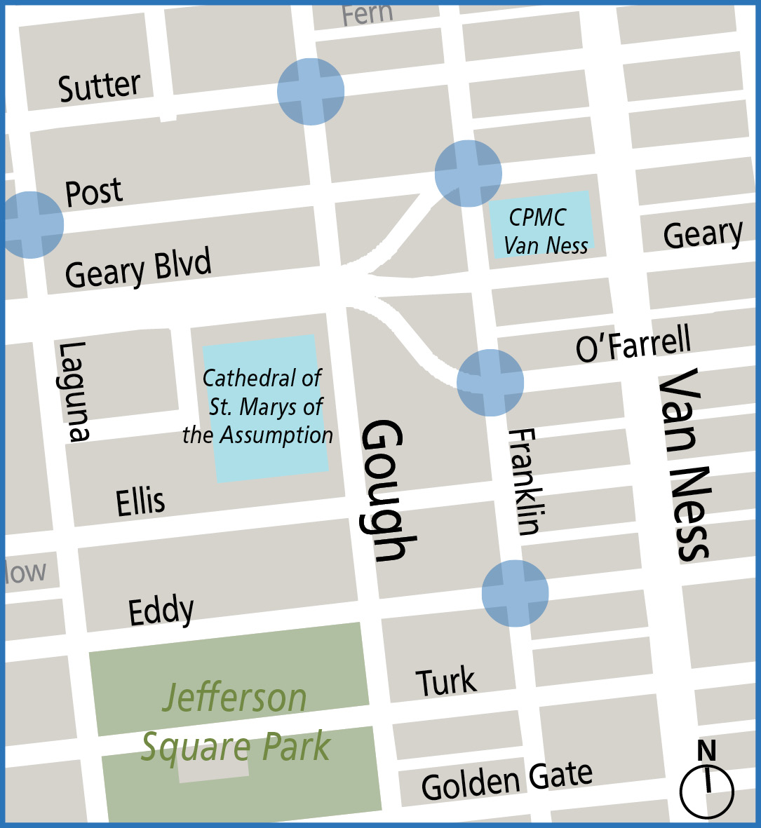
To improve pedestrian visibility at crosswalks, the study team is recommending a combination of daylighting and painted pedestrian safety zones where feasible at multiple intersections across Cathedral Hill and Presidio Heights. Intersections for painted safety zones were prioritized based on the number of recent collisions and proximity to land uses that draw vulnerable road users. Daylighting near crosswalks can be paired with installing bike parking to help reinforce parking restrictions.
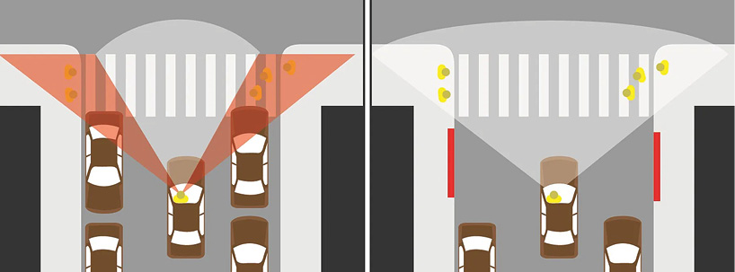
Daylighting is a way to improve the visibility of people crossing the street. By keeping the area near crosswalks clear of parked cars, people walking and people driving or riding on the street can see each other better. This is especially important for children, who are shorter and more likely to be blocked from view in intersections by parked cars. Daylighting at 80 intersections in the Tenderloin led to a 14% decrease in reported collisions.
In October 2023, Governor Newsom signed Assembly Bill 413 which adds 20 feet of daylighting to all intersections. With AB 413, California joins more than 40 other states that also mandate daylighting.
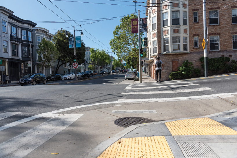
Painted safety zones are a painted buffer around sidewalk corners to make pedestrians more visible to people driving. They also encourage yielding and slow down drivers making turns. In 2016, SFMTA found that painted safety zones slowed turning speeds by up to 55% and increased the number of drivers who fully yielded to pedestrians by 25%.
The second round of community engagement aimed to gauge the level of support for and gather feedback on recommended safety treatments in the study areas. The study team conducted community engagement in fall 2025 through both online and in-person events. In-person events included three pop-up events and five presentations to merchant and neighborhood associations. The study team also distributed an online survey through social media, newsletters, emails, and mailers. The survey was open from October to November 2025 and received 92 responses. The majority of respondents (about 70%) were new to the study, and had not participated in the first phase of outreach in summer 2024, which asked participants about the safety and access challenges faced when traveling in District 2.
The survey received the most responses from the Pacific Heights, Western Addition, Japantown area, which includes both the Pacific Heights and Anza Vista study areas. The survey also received many responses from the Marina neighborhood, but fewer respondents in the Presidio Heights and Cathedral Hill study areas. There were also a small number of respondents who live outside of District 2. Compared to the first round of outreach, a higher percentage of respondents were residents in the Pacific Heights/ Western Addition/ Presidio Heights/ Japantown neighborhood (55% in round 2 vs. 39% of respondents in round 1). There were slightly fewer respondents from the Marina/ Cow Hollow neighborhood (28% in round 2 vs. 30% in round 1).
The study team compared the race/ ethnicity, income, and age of survey respondents to the 2023 American Community Survey (ACS) Five-Year Estimates for District 2. Figure 5-1 shows an underrepresentation of Hispanic/ Latino respondents and overrepresentation of Caucasian/ white, Black/ African American and Asian respondents. In comparison to the first round, the second round of outreach engaged with a slightly more diverse population, with a higher percentage of Asian respondents. However, these findings may not represent all survey respondents, as 29% of respondents skipped the demographics questions and 15% selected “Prefer not to say” for their race/ethnicity.
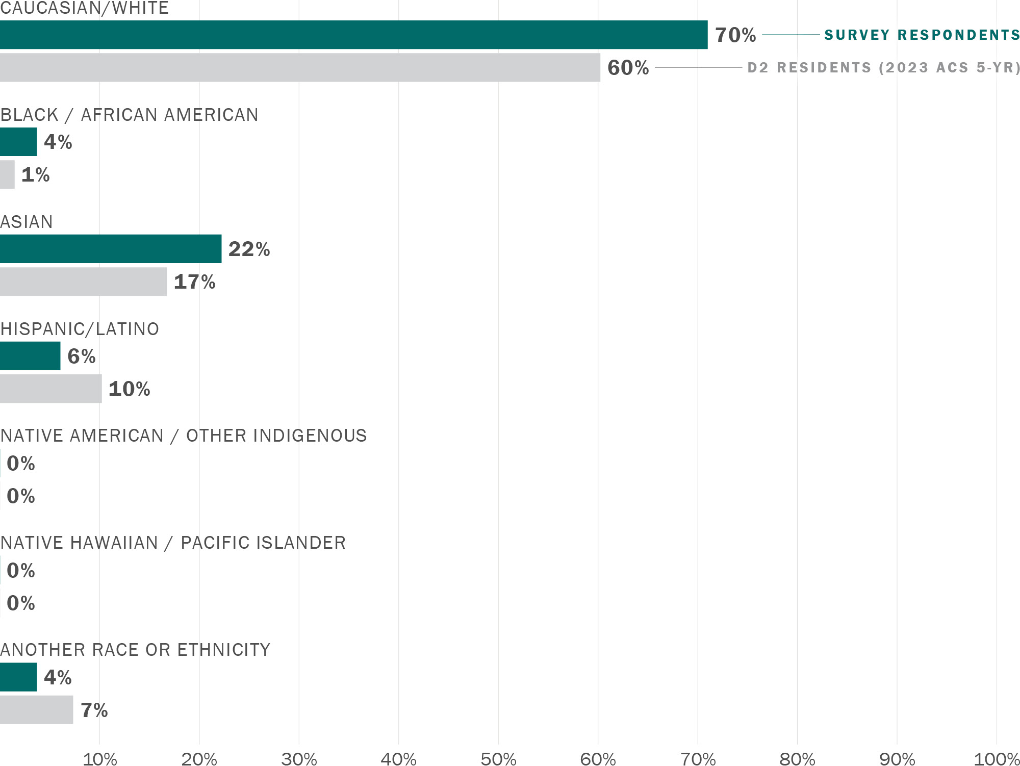
Note: chart excludes 14% of respondents who selected "Prefer not to say"
Download chart data (CSV)
The age of survey respondents skewed older than that of the district as a whole. About 80% of respondents were 35 or older, compared to 55% of District 2 residents.
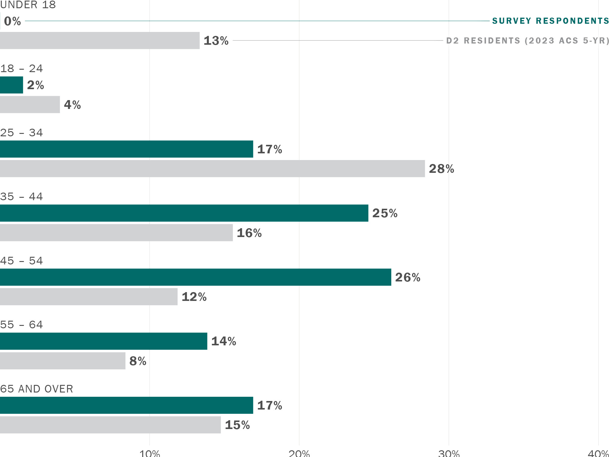
Note: chart excludes 10% of respondents who selected "Prefer not to say"
Download chart data (CSV)
In general, survey respondents had similar income levels compared to District 2 overall. However, about 29% of survey respondents skipped demographics questions, and another 26% of respondents selected “Prefer not to say” for the household income question.
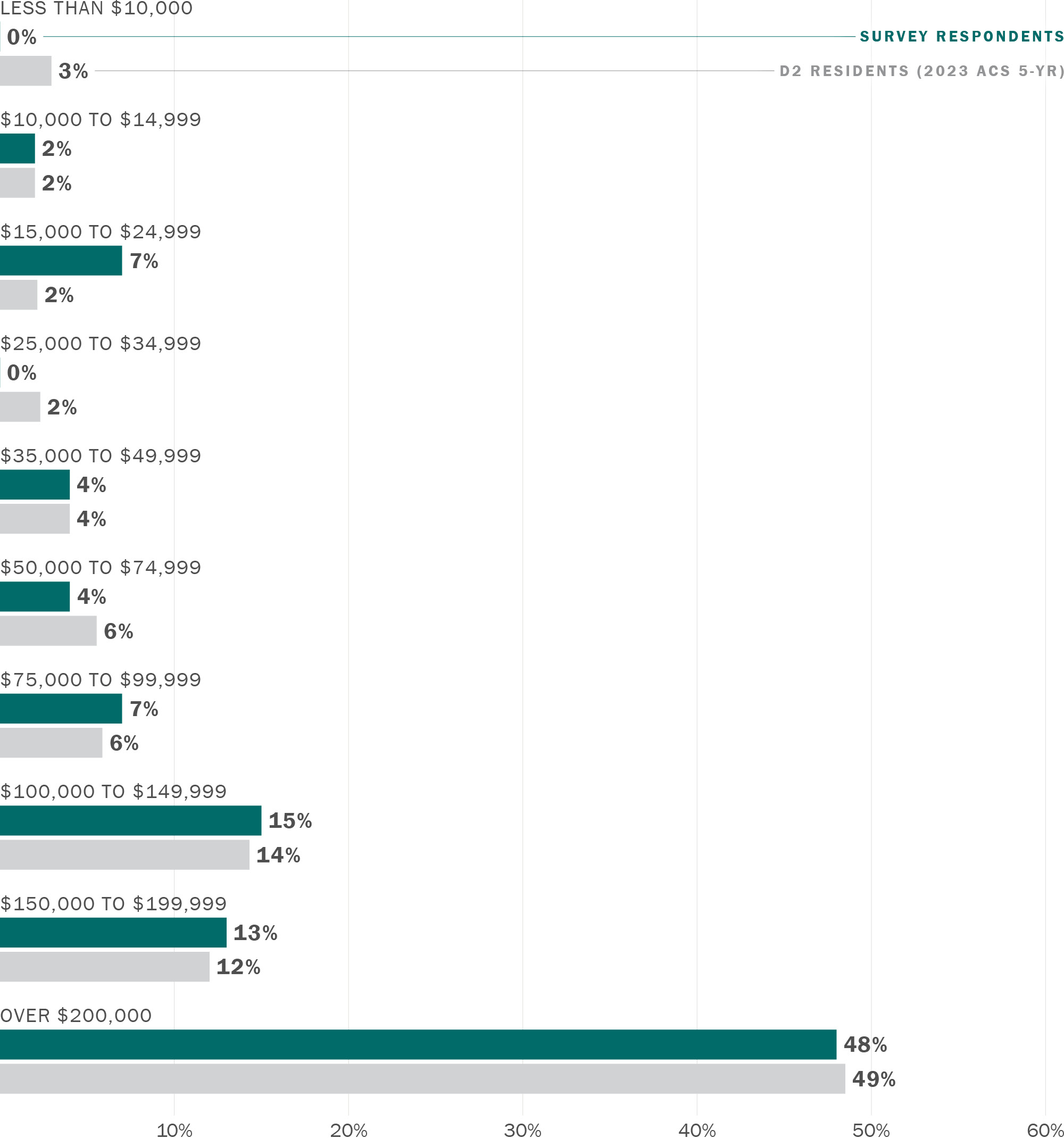
Note: chart excludes 46% of respondents who selected "Prefer not to say"
Download chart data (CSV)
The survey asked respondents to provide feedback on proposed quick-build measures in one or more study areas. The findings show that, in general, community members support the proposed recommendations. Specific feedback for each of the recommendations is summarized in the following sections.
The proposal for the Bay/Laguna intersection in the Marina received 48 survey responses. The majority of survey respondents supported two of the proposed quick-build changes: installing an LED “No Right Turn on Red” sign (75% support) and adding double yellow striping to the south side of the intersection (71% support). Fewer respondents supported adding a crosswalk closure sign to the east side of the intersection, but there were still more respondents who supported the proposal than those who did not (42% support, 35% do not support, and 23% neutral).
Community members who attended pop-up events and neighborhood association meetings were also generally supportive of the quick-build recommendations, with the exception of the crosswalk closure sign. Community members questioned whether it would make more sense to add a crosswalk to the east side of the intersection, where there is currently no crosswalk, rather than installing a crosswalk closure sign, which was seen as restrictive to pedestrian movement. However, the project team shared that the current intersection configuration does not allow for a crosswalk to be added, due to the double channelized right turn lane from westbound Bay Street onto northbound Laguna Street. Instead, this idea could be explored as part of an intersection redesign, which was proposed as a medium- to long-term recommendation.
A medium-term recommendation to study a full intersection redesign at Bay/Laguna would study reconfiguring the intersection to allow movements like a more traditional intersection. Adding a crosswalk on the east side of the intersection, as mentioned by community members in outreach, is an option that could be explored as part of this study. About 70% of survey respondents supported the recommendation to study a full intersection redesign. Capital work to implement the future intersection redesign study recommendations would happen in the long-term.
Outside of the proposed recommendations, community members also shared feedback on other issues at the Bay/Laguna intersection. Community members pointed out gaps in the bike network, such as the lack of a bike lane on the east side of Bay Street and limited connectivity between the Presidio and the Embarcadero through this area of District 2. Survey respondents also suggested increasing the pedestrian crossing time at the intersection and adding a northbound left turn arrow for cars on Laguna Street.
Safety issues on Lombard Street, particularly with speeding vehicles and conflicts between vehicles and pedestrians, were also a common topic among survey respondents and pop-up and community meeting attendees. Additionally, Lombard Street was the site of two pedestrian fatalities in 2024.
SFMTA, SFCTA, and Caltrans have been coordinating on potential improvements along this corridor. In response to the fatalities, Caltrans planned to add pavement markings to reinforce the 25 mph speed limit and SFMTA retimed the corridor to reduce the green timing at off-peak hours.
Additional recommendations include No Turn on Red regulations, adding high visibility backplates to improve signal visibility, and a double fine zone for speeding on Lombard. A corridor-level placemaking project on Lombard Street, with education around driver safety, could encourage drivers to slow down when using the street.
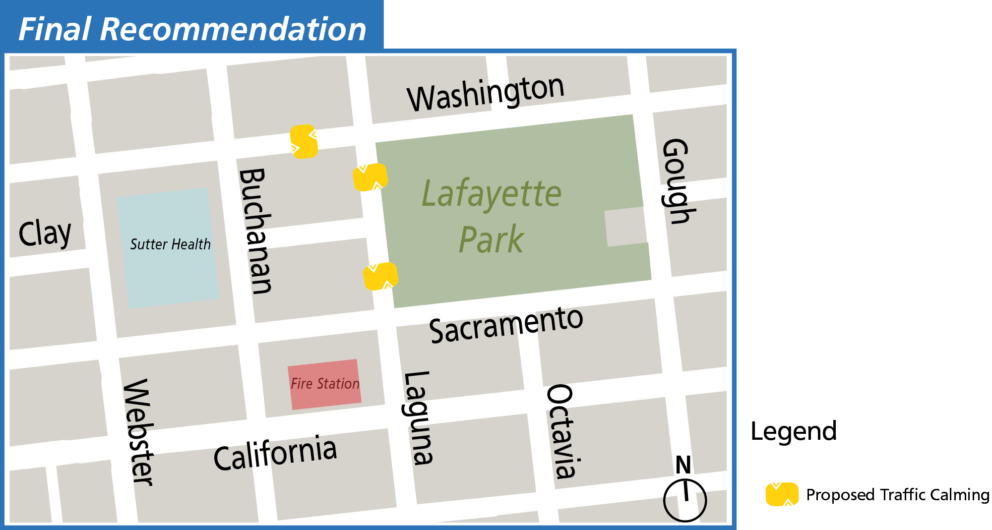
The proposal for the Clay/Webster intersection in Pacific Heights received 42 survey respondents, with the majority of respondents supporting the proposals to install traffic calming on Webster Street and Washington Street (64% of respondents), and to evaluate the balance of white and yellow curb space at Clay/Webster (63% of respondents).
At in-person outreach events, more attendees were opposed to the proposal to add traffic calming on Webster Street. Many community members shared that they had not observed high traffic speeds to be an issue on Webster Street, and that instead, traffic was often congested due to the high incidence of double parking. The congestion on Webster Street has led to cars making illegal u-turns on the street to avoid congestion, which causes further pedestrian/ vehicle conflicts. Community members suggested that the study team consider traffic calming at the intersection of Laguna/Sacramento or Laguna/Clay instead. Another major issue that community members identified was the number of scooters using sidewalks and causing conflicts with pedestrians.
In response to outreach feedback, the study team decided to shift the traffic calming proposal on Webster Street to Laguna Street from Sacramento Street to Clay Street instead. This would help slow traffic speeds near Lafayette Park.
The proposal for traffic calming in the Anza Vista residential neighborhood received 46 survey responses. The study team proposed traffic calming on six streets in this neighborhood. Five of the six streets had the majority of respondents supporting the proposal. The streets with the highest share of respondent support were: O’Farrell Street (78%), Terra Vista Avenue (75%), and Anzavista Avenue (66%). Barcelona Avenue and Fortuna Avenue had 51% of survey respondents supporting traffic calming proposals and Encanto Avenue had 49% support. Findings were similar at the pop-up event held in the Anza Vista neighborhood, with O’Farrell Street, Terra Vista Avenue, and Anzavista Avenue receiving the most support for traffic calming. At the pop-up event, community members shared that Barcelona, Fortuna, and Encanto Avenues were “smaller” streets with less traffic, and therefore may require fewer traffic calming interventions.
At the neighborhood pop-up event, community members also shared other suggestions, including adding crosswalks to improve pedestrian visibility and stop signs to slow down vehicle speeds. Community members specifically identified the following intersections as places that could benefit from a stop sign: O’Farrell and Lyon, Terra Vista and Baker, and Terra Vista and Anzavista. Community members had also observed non-compliance with the road diet on O’Farrell Street, which reduced the number of traffic lanes from two to one using painted markings. Many vehicles were still using O’Farrell as a two-lane street, even after the road diet was implemented. The City Center parking lot exit was also raised as an issue, as community members had observed vehicles exiting the parking lot and the electric vehicle charging station driving the wrong way on O’Farrell to get to Anzavista Avenue.
Finally, community members were concerned about the new T&T supermarket, expected to open in winter 2026 at 2675 Geary Boulevard near the intersection of Geary Boulevard and Masonic Avenue, which could increase traffic to the area and worsen existing issues with cut-through traffic and congestion. The T&T supermarket may also increase the amount of commercial traffic using the streets in the neighborhood, which community members said was an existing issue because of the Target and Kaiser facility that both receive a large amount of deliveries.
In response to outreach feedback, the SFMTA will implement traffic calming measures at O’Farrell Street, and Terra Vista, Anzavista, Barcelona, Fortuna, and Encanto Avenues. Regarding the suggestion for a stop sign at the O’Farrell/Lyon intersection, there is no crash pattern at this intersection and it is unlikely that a stop sign would be recommended. Furthermore, Lyon Street already has a stop sign and stop bar. The crosswalks on this street will also be updated to high-visibility crosswalks after repaving is complete. SFMTA will also review the community suggestions for stop signs at the Terra Vista/Anzavista intersections, and other measures to address safety conflicts in the neighborhood such as crosswalks and reinforcing the existing road diet on O’Farrell. The Terra Vista/Baker location has already been evaluated by the SFMTA Operations division and found that the collision history at this intersection did not warrant a full stop sign. However, daylighting has been recommended by SFMTA at this intersection and will be implemented by the Operations division.
The proposals for pedestrian and cyclist safety at the Geary/Masonic intersection received 48 survey responses. Overall, a majority of respondents support the proposals, with the highest support for Lead Pedestrian Intervals (78%), cyclist wayfinding with pavement markings through the intersection (76%), and No Turn on Red signage (72%). Installing a bike box at the intersection of Masonic Avenue and O’Farrell Street and rounding the concrete island nose at the bike lane entrance both received support from 58% of respondents.
Lead Pedestrian Intervals were also the most popular proposal among attendees at pop-up events, along with cyclist wayfinding with pavement markings. Other comments from community members included improving wayfinding and signage for cars navigating the Geary/Masonic intersection.
Turk Boulevard was also often mentioned in outreach as a location with high vehicle speeds, particularly between Masonic Avenue and Divisadero Street. Turk Boulevard from Arguello Boulevard to Masonic Avenue was previously identified as an area with opportunity for further improvements in the Transportation Authority’s District 1 Multimodal Transportation Study. Safety analysis of Turk Boulevard in District 1 found several intersections with comparatively high pedestrian and bicyclist crash severity scores. The District 1 Multimodal Transportation Study considers a concept to improve bicycle connectivity and safe access to transit, including separated bike lanes, curb extensions, and bus boarding platforms. In the future, a study of Turk Boulevard from Arguello Boulevard to Divisadero Street could address these issues more comprehensively.
The study team asked community members about priority locations for short-term and long-term secure bike parking in the Presidio Heights neighborhood. This question received 30 responses in the survey. The most popular locations for bike parking were along Arguello Boulevard and near Claire Lilienthal Elementary School. About one-third of respondents stated that they did not want more bike parking in the neighborhood.
In community meetings, community members shared that adding more simple bike parking was sufficient, rather than more complex bike lockers or bike hangars. This bike parking could be combined with daylighting to reinforce parking restrictions near crosswalks. In addition, larger e-bikes take up more space at bike racks, and as the number of e-bikes continues to grow in San Francisco, this should be taken into account when allocating bike parking.
In Cathedral Hill, the study team proposed traffic safety measures, such as painted safety zones, at five intersections with a high number of recent turn-based collisions and asked respondents to select priority locations. This question received 29 responses in the survey. The top three priority locations to receive traffic safety measures based on survey responses were: Post Street and Franklin Street (79% of respondents), O’Farrell Street and Franklin Street (76%), and Eddy Street and Franklin Street (62%).
Attendees at pop-up events were also supportive of proposed pedestrian visibility improvements in Cathedral Hill. One attendee shared that there are many assisted living facilities in Cathedral Hill, so there are many seniors and people with mobility challenges using the sidewalks and crossing the street who would benefit from these improvements.
The project team developed planning level cost estimates for the design and implementation of near-term quick-build recommendations, and cost estimates for design or further study of medium- and long-term recommendations. The near-term quick-build recommendations can be funded with $430,000 of previously allocated sales tax funds from the Neighborhood Transportation Program, which are reserved in the Transportation Authority’s Prop K transportation sales tax program, pending completion of this plan. The Transportation Authority Board may release these funds for the scope of work proposed below and following the adoption of this final report. For the medium- and long-term recommendations, the project team has identified potential funding sources, summarized below.
The cost estimates for near-term, quick-build recommendations are summarized in the table below. Recommendations were finalized and prioritized based on findings from the second round of community engagement.
The table below summarizes the estimated cost and funding sources for design and further study of medium- and long-term study recommendations.
In 2022, San Francisco voters approved Proposition L (Prop L), the Sales Tax for Transportation, which directs half-cent sales tax funds to a 30-year Expenditure Plan that identifies projects and programs to be funded by the sales tax. The Expenditure Plan describes the types of projects eligible for funds under each of its 28 programs. This project’s recommendations, which are focused on pedestrian and cyclist safety, may be eligible under the following Prop L program:
The Proposition D Traffic Congestion Mitigation Tax (TNC Tax) was passed by San Francisco voters in 2019. The TNC Tax charges a 1.5% tax on shared TNC rides and 3.25% for all other TNC rides. The Transportation Authority’s share of 50% of TNC Tax revenues are available for street safety projects including pedestrian or bicycle safety projects, traffic calming, and traffic signal upgrades and re-timing.
Proposition AA is a voter-approved $10 annual vehicle registration fee that funds local street repair and reconstruction, pedestrian and bicycle safety improvements, and transit reliability and mobility improvements throughout San Francisco. Given its small size — less than $5 million in revenue per year — Prop AA is used to support small, high-impact projects that provide tangible benefits to the public in the short term, and only funds design and construction phases of projects.
Prop AA projects are split into three categories:
Prop AA could fund the design and construction phases for projects that include pedestrian improvements.
Some discretionary funding may be available within the General Fund budgeting process for the types of recommendations included in this plan.
The following regional, state, and federal funding sources are also available to implement pedestrian safety recommendations. These funding sources are intended to fund larger projects, and may not be appropriate for the relatively lower cost ($200,000 to $250,000) long-term bike improvement recommendation at Bay Street / Laguna Street. However, the programs listed below are possible sources for the implementation of recommendations from a future study. Some additional recommendations for future study are also listed below
California Senate Bill 1 (SB 1) was signed into law on April 28, 2017. SB 1 provides $5.4 billion annually toward transportation in California, funding a wide variety of transportation projects through many different grant programs. Among those, SB 1 provides approximately $25 million in funds for Sustainable Communities Grants each grant cycle, which are intended to support strategies to achieve the state’s greenhouse gas reduction target of 40 and 80 percent below 1990 levels by 2030 and 2050, respectively.
The state Department of Transportation (Caltrans) provides grants to encourage increased use of active modes of transportation. This highly competitive program could fund the bike and pedestrian safety infrastructure recommendations that stem from future studies but the program emphasizes projects that benefit disadvantaged communities and measurably increase walking and biking. Only projects requesting more than $250,000 are eligible. Therefore, ATP is an unlikely funding source for the project recommendations but could fund implementation of recommendations from future studies for the Bay Street/Laguna Street intersection.
The Highway Safety Improvement Program (HSIP) is one of the core federal-aid programs to states. The purpose of the HSIP program is to achieve a significant reduction in traffic fatalities and serious injuries on all public roads, including non-State-owned public roads and roads on tribal land. Example safety projects include but are not limited to crosswalk markings, rapid flashing beacons, curb extensions, speed feedback signs, median islands, and other pavement markings. In California, HSIP prioritizes projects based on a benefit-to-cost ratio. Projects along roadways with a relatively high crash history (e.g., Lombard Street) may be able to achieve a competitive benefit-to-cost ratio and be funded through HSIP.
Through the Infrastructure Investments and Jobs Act, USDOT provides funding for several types of projects, including funding for active transportation projects and programs. One program, the Safe Streets for All (SS4A) Grant Program, can fund bike safety improvements.
In addition to these specific medium- and long-term projects, the study team heard community feedback about broader issues in the district such as speeding, double parking, and scooter use on sidewalks. Below is a list of recommendations for these issues that could be addressed with further funding.
Finally, there were some streets, including Turk Boulevard and Lombard Street, that were often mentioned in outreach as needing safety improvements. Recommendations for these streets are summarized below.
The District 2 Safety Study was funded through the San Francisco County Transportation Authority’s Neighborhood Program at the request of former Commissioner Catherine Stefani. The Neighborhood Program was established to fund community-based efforts in San Francisco neighborhoods, especially in underserved neighborhoods and areas with vulnerable populations (e.g., seniors, children, and/or people with disabilities). The Neighborhood Program is made possible with San Francisco’s half-cent sales tax for transportation funds.

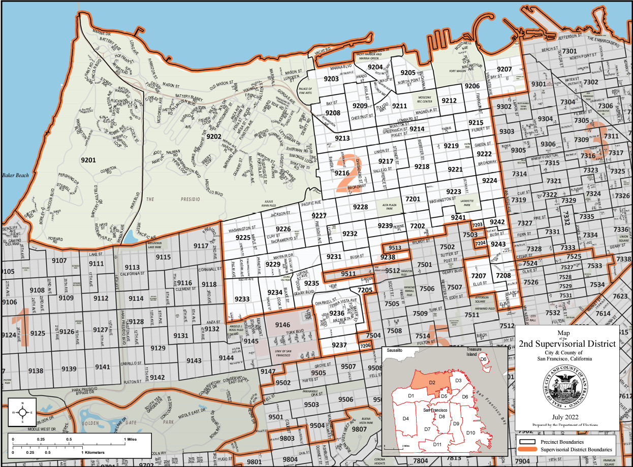
This memo details the process for selecting the specific study areas for the District 2 Safety Study. The study team first identified “attractors” of vulnerable road users such as children, seniors, and people with disabilities. Based on the map, the study team determined up to six specific areas with access gaps and known safety challenges within D2’s existing transportation network.
Attractors of vulnerable road users include:
The study team also considered other demographic, geographic, and transportation related factors that could indicate safety and access barriers when developing the study area map. These factors included:
After developing the map, the study team identified access gaps near attractors. This included scanning for the presence and quality of crosswalks, protective bike lanes, and sidewalk width, locating potential gaps in the bike network, and bus stops placed too far or inconveniently situated away from attractors, or situated at a busy intersection.
The next section is a summary of data sources used for developing the study area map.
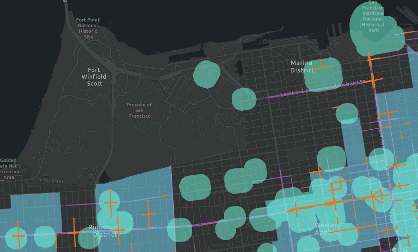
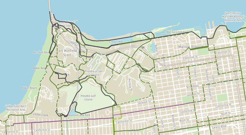
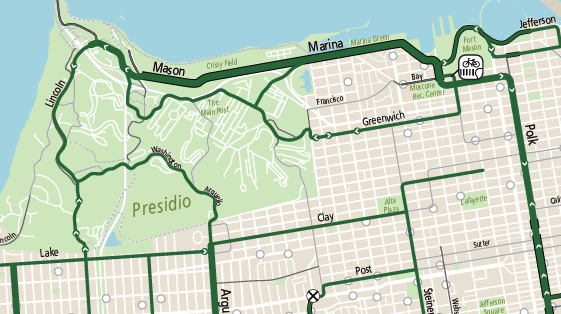
Dashed lines = bike route/neighborway
Bold lines = bike lane, bikeway, or separated bike path
Purple lines = Implemented Slow Streets
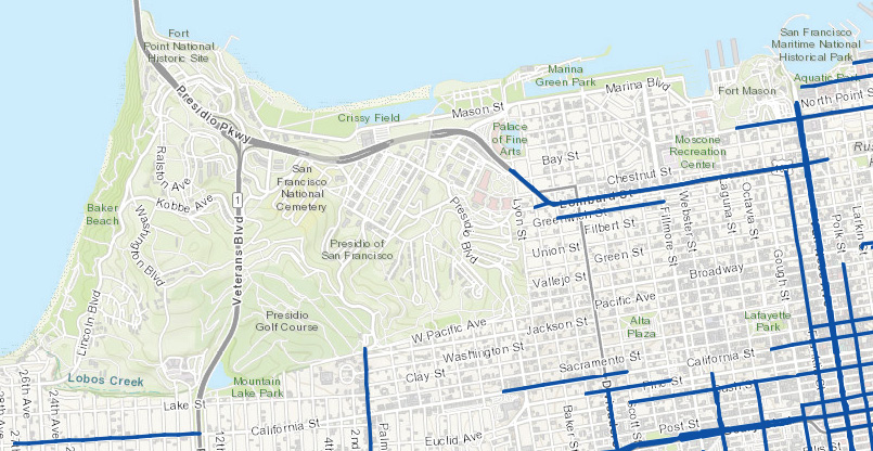
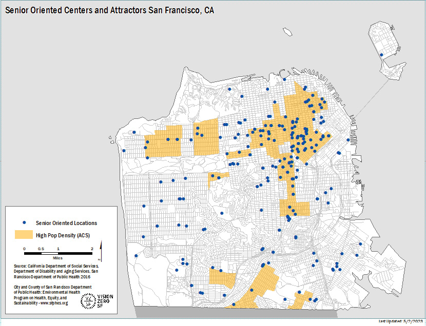
This map was provided by SFMTA staff. Blue dots are the same locations as the DPH 2017 map above. SFMTA staff also provided an Excel dataset that includes all SF Paratransit van and taxi trips from January 2022-March 2023. The table below summarizes this data set and represents Paratransit van and taxi stops in District 2, not trips.
|
Taxi |
Van |
|
|---|---|---|
|
2022 |
79848 |
30245 |
|
Jan |
6224 |
2010 |
|
Feb |
6285 |
2125 |
|
Mar |
7395 |
2642 |
|
Apr |
6949 |
2531 |
|
May |
6962 |
2553 |
|
Jun |
6474 |
2691 |
|
Jul |
6512 |
2574 |
|
Aug |
6762 |
2578 |
|
Sep |
6487 |
2640 |
|
Oct |
6804 |
2704 |
|
Nov |
6560 |
2600 |
|
Dec |
6434 |
2597 |
|
2023 |
18136 |
8353 |
|
Jan |
5678 |
2704 |
|
Feb |
5938 |
2675 |
|
Mar |
6520 |
2974 |
The attractors and other safety and access factors are summarized in the map below.
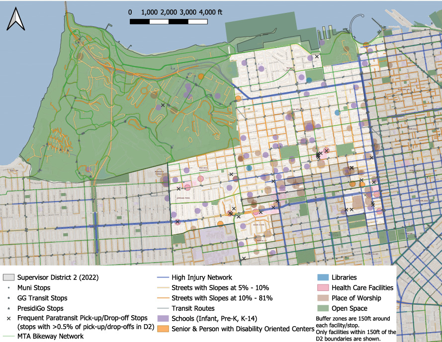
The transportation component of the map shows transit stops, HIN, bikeway network, frequent paratransit pick up/ drop off spots, and street slopes. Frequent paratransit stops are defined as stops with >0.5% of pickups and drop offs in D2, which are the top 30 pick up/ drop off spots from the data provided by SFMTA. An observation from the map is that most of the bikeway network in District 2 is on shared streets, with very few separated or protected bike lanes.
The study team also looked at the distribution of land uses in the district. Schools are spread throughout District 2, with some clustering in the center of the district. There are six senior and disability-oriented centers with two near the Presidio, two in the southeastern corner of the district, one near the SF Maritime National Historic Park, and one next to USF Lone Mountain Campus. Meanwhile, most of the healthcare facilities are clustered along the southern boundary of the district. Places of worship are distributed throughout the district with slightly more clustered along the southern and eastern boundary. There are three libraries in District 2 and five open spaces (the Presidio, Lafayette Park, Alta Plaza Park, Fort Mason, and Marina Green).
The study area map shows the locations of key attractors and transportation and other features, and the study team made additional observations. Paratransit stops may indicate attractor locations, but transportation improvements may be a lower priority at the location because paratransit is a door-to-door service. Furthermore, not all land uses should be weighed the same, as there are periodic daily/weekly rhythms to these sites. For example, churches and other religious sites may only be in use for a couple hours on days around the weekend, whereas hospitals would have a more constant flow of people coming in and out.
There were some locations where the bike network and the HIN overlap, indicating a potential for improvements, such as on Greenwich Street. There is also a much higher density of attractors in the southern half of District 2; an improvement in this area of District 2 has the potential to benefit a lot more users than an improvement in the northern half of the district.
The next step for the study team was to identify locations where there are clusters, or high concentrations, of attractors drawing vulnerable road users. A draft cluster map is shown below, along with focused maps for each of the clusters and a short description.
In general, places of worship and schools loosely cluster along the southern border of D2. Paratransit pick ups and drop offs also tend to cluster near healthcare and senior-oriented facilities. Healthcare facilities and frequent paratransit pick up/ drop off locations clustered in the southwestern corner of D2 near Kaiser and UCSF medical centers.
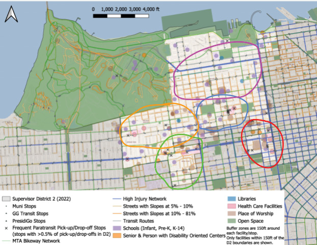
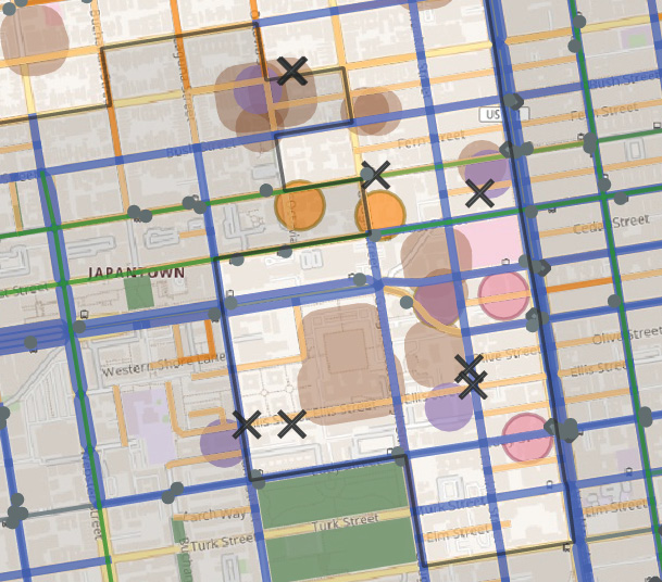
The first cluster is in the southeast corner of the District, near the Cathedral Hill and Japantown neighborhood. This cluster is predominantly composed of places of worship, schools, senior centers and healthcare facilities.
The street network is characterized by small blocks along Van Ness Avenue, with larger superblocks (from urban renewal) cut across by pedestrian walkways. Walkways in this area may not be publicly accessible, which the study team will need to investigate through an in-person site visit.
This cluster has a strong concentration of HIN segments and paratransit pick up/drop offs. Transit routes that go through this area include Muni muni routes (2, 31, 38 and 38R) and Golden Gate Transit routes (101, 130, and 150 lines.
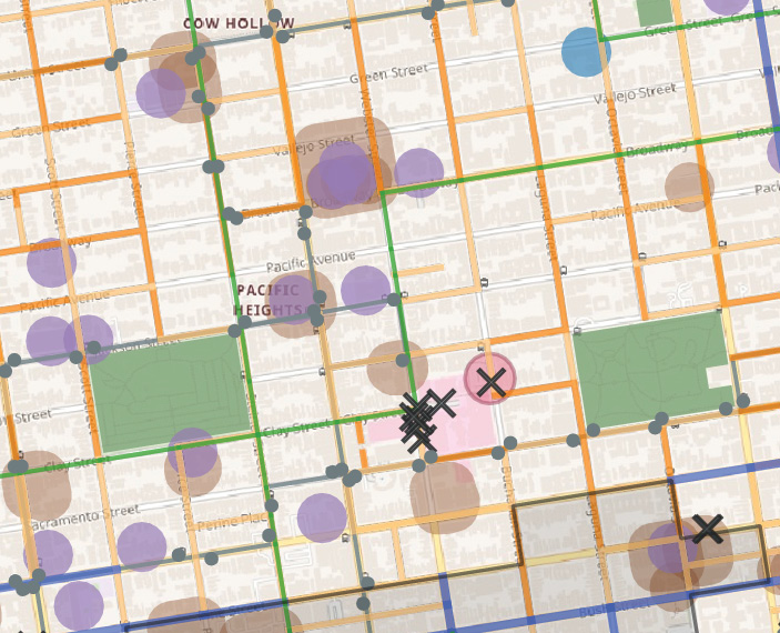
This cluster has a large concentration of paratransit pick up/ drop off locations near the CPMC Outpatient Center on Clay Street and Webster Street, as well as two large parks (Alta Plaza and Lafayette Park). Schools are also scattered throughout this area, with a small cluster around The Herbert Center (a group of Catholic schools).
This area has a standard grid street network with Muni 22, 24, and 1 bus routes passing through. There are also North-South and East-West bike route connections.
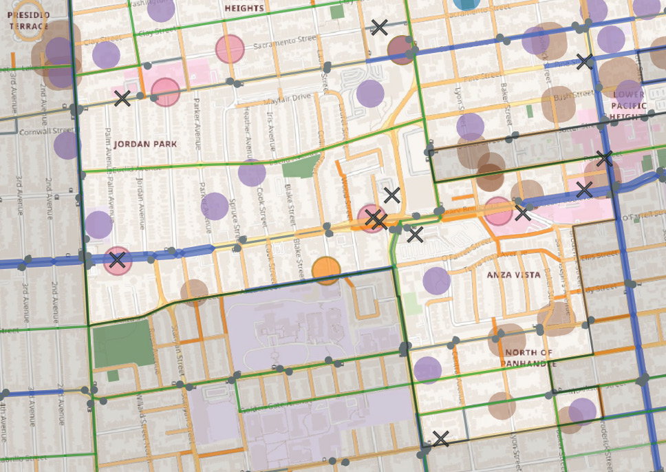
In this cluster, paratransit pick up/ drop off locations generally overlap with healthcare facilities and eldercare facilities along Geary Boulevard. There are also schools scattered throughout the area, some that have better cycling access than others. Muni routes 38/38R, 31, 43, and 1 pass through the area. There are multiple East-West and North-South cycling routes.
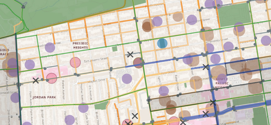
This cluster has many places of worship towards the center of the area and the southern border of D2 and schools scattered throughout but slightly clustered toward the center of the area. There are a few paratransit pick up/ drop off locations scattered throughout with some clustering near healthcare facilities along Divisadero Street.
This study area encompasses multiple sections of the HIN along California Street, Divisadero Street, Pine Street, and Geary Boulevard. Muni routes 1, 2, 22, 24, and 43 run through this area. There are bike routes along Presidio Avenue, Clay Street, and Euclid Avenue. This study area also borders EPC census tracts to the south along Sutter Street, just outside of the D2 boundaries.
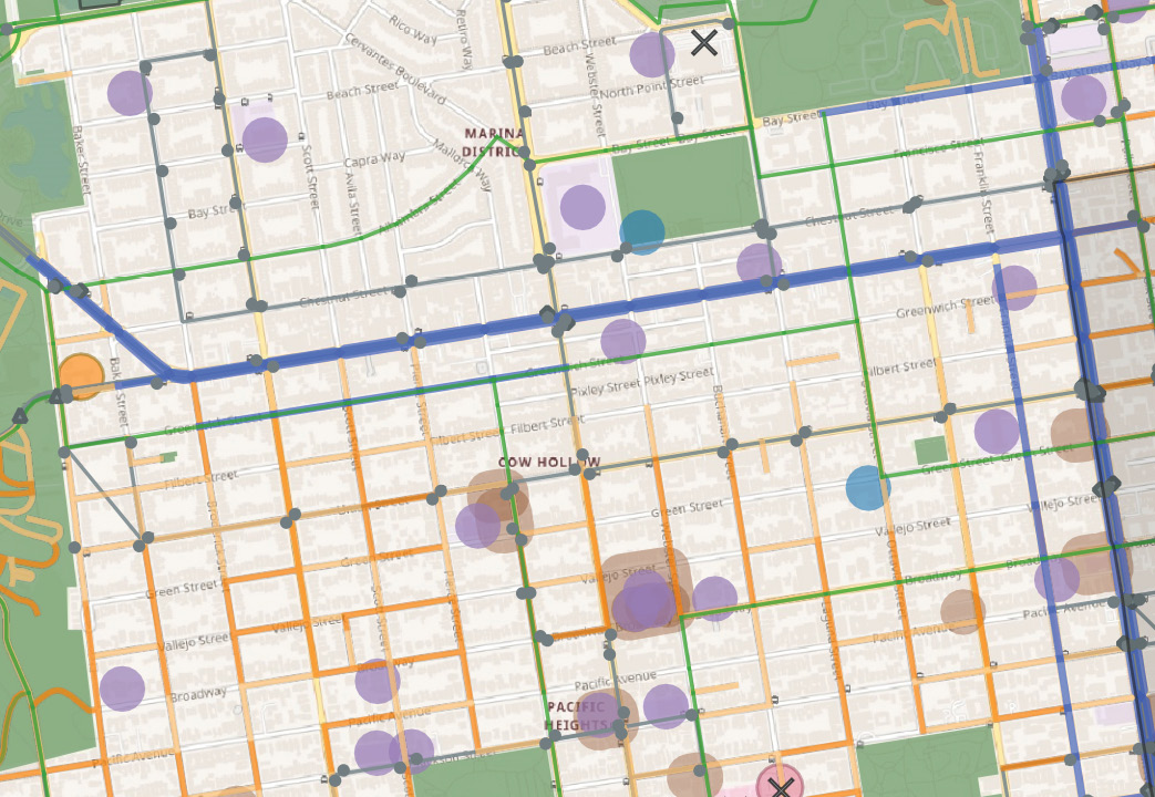
This study area has some schools and places of worship scattered throughout, with some concentrations along Vallejo Street and Union Street. There are not many paratransit pick up/ drop off locations. The street network is a standard grid with many steep slopes along residential streets south of Lombard Street. There are major HIN segments along Lombard Street, Van Ness Avenue, and Franklin Street. There are also many Golden Gate Transit and Muni routes that run through this area. The bike network is also fairly extensive, with bike facilities on Steiner Street, Greenwich Street, Francisco Street, Broadway, Pacific Street, Webster Street, and Octavia Street.
The study team identified access gaps by first inspecting cluster areas on Google Street View to get an idea of factors such as street crossing distances, bus stop location quality, and bike route consistency. This was supplemented with field visits to the cluster areas to further refine and select study areas.
For the final study areas, the study team used a set of guidelines:
The final study areas are shown on the map below.
 Download a PDF of this report