Photo: SFMTA Photography Department
Introduction
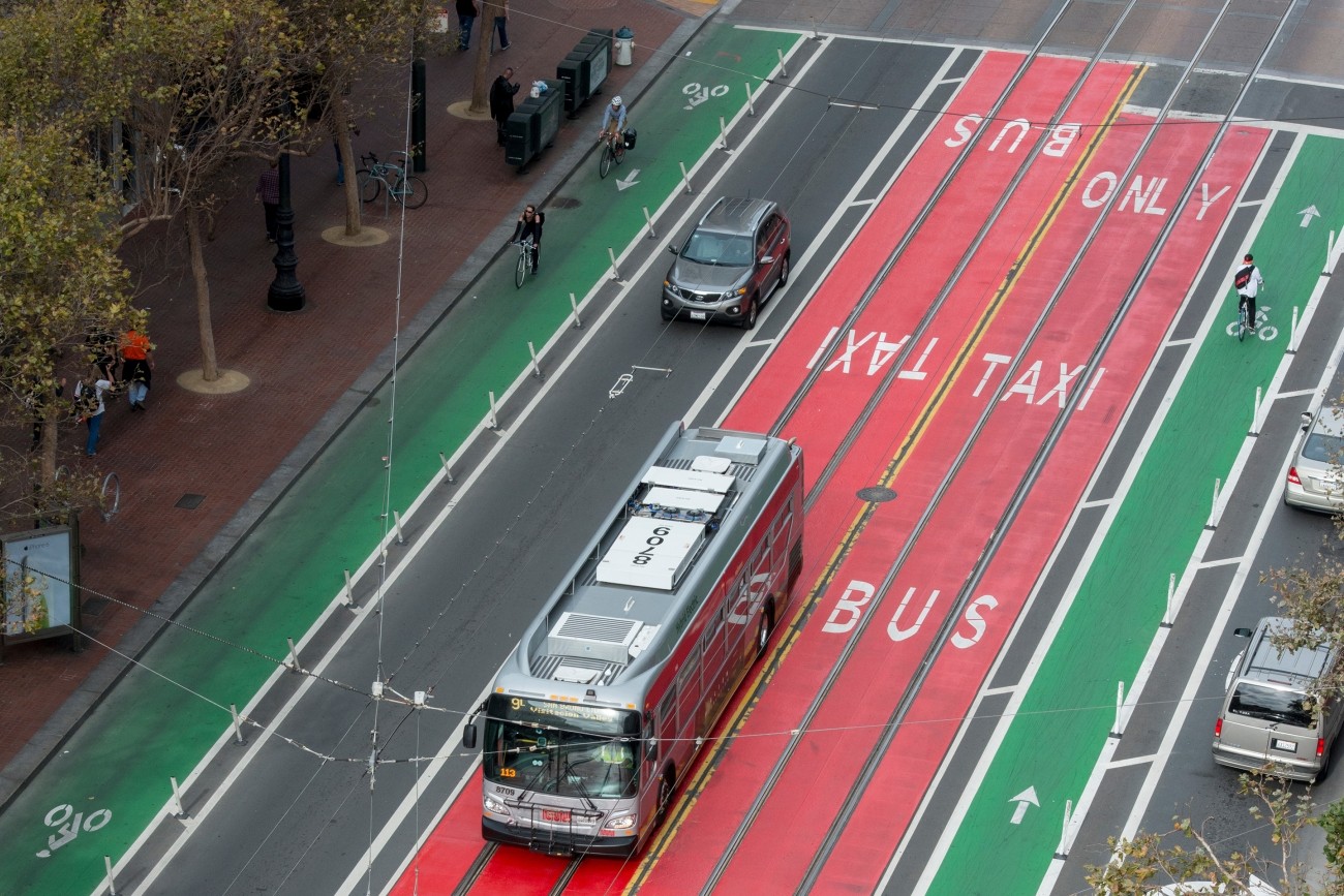
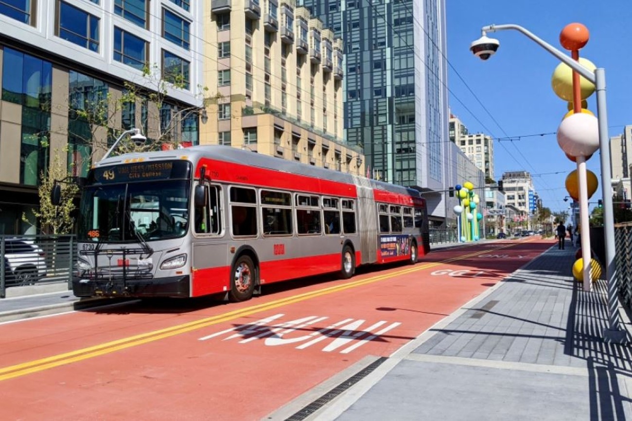
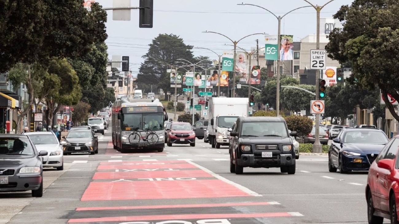
Geary Bus Rapid Transit will improve Geary Boulevard with much-needed safety improvements and faster, more reliable bus service for the tens of thousands of people who use the 38 Geary and 38R Geary Rapid bus routes every day. Project improvements include red bus-only lanes, signal priority for buses, and safety improvements such as sidewalk extensions and accessible curb ramps.
Project Features
More efficient and reliable transit makes bus service 20 percent quicker along the corridor. Buses arrive more frequently and improved reliability provides more consistent wait times.
More accessible bus stops with sidewalk extensions make it easier to get on and off the bus, promote safer crossings and shorter crossing distances. These improvements combined with upgraded traffic signals will enhance safety.
A smoother roadway with newly paved streets.
More reliable utilities with new water and sewer infrastructure.
Timeline and Status
Geary Bus Rapid Transit was implemented in two phases.
Phase 1: Geary Rapid Project
Project boundaries: On Geary from Market to Stanyan
The Phase 1 Geary Rapid Project was completed in 2021. This phase included painting bus-only lanes and stop changes between Market and Stanyan streets. In addition, this phase of work installed new traffic signal infrastructure and pedestrian and bus bulbs. This phase of enhancements improved transit travel time and transit reliability along Geary.
Phase 2: Geary Boulevard Improvement Project
Project boundaries: On Geary from Stanyan to 34th Avenue
The Phase 2 Geary Boulevard Improvement Project will extend enhancements from Phase 1 to the western part of the corridor between Stanyan Street and 34th Avenue in the Richmond District. This phase of the project would improve bus service along Geary and improve traffic safety by installing side-running transit lanes, signal priority for buses, and retimed pedestrian signals to give people walking more time to cross the street. This phase of the project is currently in design and will be coordinated with the SF Public Utilities Commission's planned water and sewer utility upgrades.
Project Partners
This project is led by the SFMTA in partnership with SF Public Works and the San Francisco Public Utilities Commission.
The Transportation Authority led this project through the environmental planning phase in partnership with the SFMTA and is providing funding through Prop K, Prop AA and One Bay Area Grant regional funds.
With $51 million of Prop K half-cent sales tax funds supporting the project, the Transportation Authority continues to provide project support and oversight.
Cost and Funding
Phase 1 was completed with a cost of $36 million in bus rapid transit scope and an additional $30 million coordinated infrastructure upgrades. The project was funded with Transit Performance Initiative funds and various local funds, including the Prop K transportation sales tax and Prop AA Vehicle Registration fee.
Phase 2 is estimated to cost $48 million for the bus rapid transit scope. Funding of Phase 2 includes Prop K sales tax, Prop AA, Transit and Intercity Rail Capital Program, and local funding.
Resources
SFMTA Geary Rapid Project webpage
SFMTA Geary Boulevard Improvement Project webpage
Contact
capitalprojects@sfcta.org
The more than tens of thousands of daily riders on the 38 Geary need more efficient and reliable transit service. Bus Rapid Transit on Geary will provide those service improvements.
There are many different elements that make up a Bus Rapid Transit system. One of the main features is dedicated bus lanes, which get buses out of congested traffic and reduce delays. New boarding platforms are another part of a Bus Rapid Transit system and make it safer and easier to get on and off the bus. Other features that keep the buses moving, like stop changes and traffic signal adjustments, will save riders even more time. By combining all these elements, we expect bus travel times to be reduced as much as 20 percent upon completion.
The Transportation Authority Board approved the Geary Bus Rapid Transit Project and certified the Final Environmental Impact Report on January 5, 2017. The Federal Transit Administration issued its Final Environmental Impact Statement and Record of Decision in the Federal Register on June 1, 2018, representing the project's final environmental approval. The project later received SF Planning CEQA approval for a side-running version of the Geary Boulevard Improvement Project on July 21, 2023.
While the Geary Bus Rapid Transit has been decades in the making—we're also looking to the future of transportation on the corridor. The project's design allows for the addition of future rail service. The City is currently evaluating longer-term plans for the San Francisco's rail network, including the Geary corridor. That means rail could be installed if funding becomes available. This flexibility makes Geary Bus Rapid Transit a good investment both for the near-term and the future.
Citizens Advisory Committee
The Transportation Authority's Geary Bus Rapid Transit Citizens Advisory Committee, which advised our agency throughout the environmental analysis, has concluded its work on the project.
The SFMTA has formed a new Geary Community Advisory Committee to advise on the design and implementation phases of the project.
Public Feedback during the Environmental Phase: What We Heard and What We Did
Residents, community leaders, advocates and merchants all along the corridor contributed to the design for Geary Bus Rapid Transit.
Their input resulted in:
- Preserving a local bus stop at Collins Street and Rapid stop at Laguna Street
- Safe and efficient transit access for students: Bus-only lanes will extend to 34th Avenue to serve nearby schools
- Keeping the Webster Street bridge: The pedestrian bridge at Webster Street will be preserved with new crossings and medians on either side of the street
- Maintained turns: The project will keep key left turns and all right turns on the corridor
- Adding a dedicated turn lane for access to the Japantown Garage
- Improved safety: The project will make crossing Geary safer with more than 100 sidewalk extensions and bike improvements along key north-south bike routes
San Francisco Planning California Environmental Quality Act Determination (2023)
SF Planning CEQA Statutory Exemption Determination for the Geary Boulevard Improvement Project (between Stanyan Street and 34th Avenue). This determination was for SFMTA's proposal to implement elements that would include: transit lane between 28th and 15th avenues, relocating 10 bus stops, pedestrian safety improvements, and traffic signal upgrades.
CEQA Statutory Exemption Determination, July 2023 (PDF)
National Environmental Policy Act Re-Evaluation
A NEPA Re-evaluation describes and considers several additional design changes to the first phase of the project, between Market Street and Stanyan Street, made in response to community feedback and additional technical work during SFMTA's final design process. Based on the re-evaluation materials, the Federal Transit Administration found that the design changes are not substantial and would not require further assessment.
Download the NEPA Re-Evaluation (PDF)
Final Environmental Impact Statement and Record of Decision (2018)
The Final Environmental Impact Statement and Record of Decision represent the final federal environmental review actions under the National Environmental Policy Act.
Complete Final EIS without appendices (PDF)
Record of Decision (PDF)
Environmental Impact Statement Chapters
Cover and Signature page (1.7MB)
Table of Contents (598 KB)
Chapter 1 (1.4 MB)
Chapter 2 (3.4 MB)
Chapter 3.0-3.2 (747 KB)
Chapter 3.3 (1.3 MB)
Chapter 3.4 (2.4 MB)
Chapter 3.5 (1.3 MB)
Chapter 3.6 (745 KB)
Chapter 4.0 (90 KB)
Chapter 4.1 (1.5 MB)
Chapter 4.2 (2.2 MB)
Chapter 4.3 (167 KB)
Chapter 4.4 (3.2 MB)
Chapter 4.5 (2 MB)
Chapter 4.6 (318 KB)
Chapter 4.7 (857 KB)
Chapter 4.8 (1.3 MB)
Chapter 4.9 (597 KB)
Chapter 4.10 (715 KB)
Chapter 4.11(958 KB)
Chapter 4.12 (161 KB)
Chapter 4.13 (249 KB)
Chapter 4.14 (2.1 MB)
Chapter 4.15 (967 KB)
Chapter 4.16 (62 KB)
Chapter 4.17 (49 KB)
Chapter 5.0 (825 KB)
Chapter 6.0 (1.1 MB)
Chapter 7.0 (119 KB)
Chapter 8.0 (392 KB)
Chapter 9.0 (237 KB)
Chapter 10.0 (1.2 MB)
Chapter 11.0 (138 KB)
Appendices
Appendix A (PDF)
Appendix B-E (PDF)
Appendix F-G (PDF)
Appendix H-I (PDF)
Appendix J-L (PDF)
Appendix M-N (PDF)
Final Environmental Impact Report (2017)
Addenda to the Environmental Impact Report
The First Addendum to the Final Environmental Impact Report reflects a modification to the project design between 26th Avenue and 28th Avenue that was approved by the San Francisco County Transportation Authority Board on June 27, 2017, as well as refinements to the planned construction phasing.
The Second Addendum to the Final Environmental Impact Report reflects several additional design changes to the first phase of the project, between Market Street and Stanyan Street, made in response to community feedback and additional technical work during SFMTA's final design process.
Download the Report
Download the complete report (no appendices) in PDF format:
Complete report without appendices (PDF)
Download the report by section:
Cover, signature page, Table of Contents, List of Tables, List of Figures (2.5MB)
Chapter 1: Introduction (215K)
Chapter 2: Alternatives (840K)
Chapter 3: Transportation (789K)
Chapter 4: Affected environment, environmental consequences, and avoidance, minimization and/or mitigation measures (722K)
Chapter 5: Public participation (213K)
Chapter 6: Financial Analysis (214K)
Appendices
Appendix A: Errata Summary (4.2MB)
Appendix B: Response to Comments (25.5MB)
Appendix C: Mitigation Monitoring and Reporting Program (2.5MB)
Appendix D: Plan Drawings of the Build Alternatives (7MB)
Locally Preferred Alternative
Design drawings for the Locally Preferred Alternative including modifications (PDF)
Related programs