Image

The Geary/19th Ave Subway is envisioned as a rail rapid transit subway oriented under Geary Blvd and 19th Ave in San Francisco. An investment of this scale — a dual-track subway approximately 10 miles in length, with approximately 5 – 6 stations — is significant, with a capital cost estimated in the range of $20B – $30B. However, the potential benefits to San Francisco, the region, and the statewide rail network are transformative. This study, the Geary/19th Ave Subway and Regional Connections Study Strategic Case, aims to advance the understanding of key project development components and choices, including the anticipated benefits that the subway could deliver.
The idea for a subway under Geary Boulevard has been included in numerous studies over the past decades. Recent planning and community engagement work, documented in the Connect SF Transit Strategy (2021) and the 2050 San Francisco Transportation Plan (2022) evolved the understanding of potential needs and opportunities in both the Geary Blvd corridor and western San Francisco, resulting in a corridor that begins in Downtown San Francisco, continues west along Geary Blvd as far west as the Inner Richmond, where it turns south below Golden Gate Park and continues beneath 19th Ave through the Sunset District, terminating roughly near the existing Daly City Bay Area Rapid Transit (BART) station.
This study uses evidence and analysis to address four key questions:
These questions enable decision-makers, project partners, and the public to understand the benefits that would be unlocked by the Geary/19th Ave Subway and to guide future phases of project development.
Importantly, this study did not:
These decisions will be advanced in future phases of project development, informed by additional analysis and stakeholder engagement, should the project proceed.
The Geary/19th Ave Corridor is critically important for moving people and goods across San Francisco and the wider Bay Area. A Geary/19th Subway provides the opportunity for a high capacity, fast, frequent, and reliable transit service across the corridor and beyond. It can help meet future travel demand, support planned housing development, and better meet the evolving needs of San Francisco and the Bay Area.
Today, the Geary/19th Ave Corridor is home to nearly 29% of San Francisco’s population, 43% of its jobs, and many significant employment, cultural, academic, and social service centers and institutions. Communities along the corridor are anticipated to grow significantly in the coming decades. Population growth planned for in San Francisco’s 2022 Housing Element reflects 100,000 new people and 80,000 new jobs along the corridor.
Travel demand on the corridor is significant. Each day hundreds of thousands of trips are made to places along the corridor or to access other parts of the Bay Area. This high level of travel demand can make transit crowded and roads congested, resulting in slow and unreliable travel times.
Recently, substantial transit priority investments along Geary Boulevard and 19th Avenue have improved reliability along the congested surface network. However, they do not always provide competitive travel times for trips across the entire city or to key regional destinations elsewhere in the Bay Area, nor do they provide the capacity needed to serve future demand. The improvements required to meet these needs are not achievable solely with at-grade transit service. A new grade-separated rapid transit service — a subway — is needed to provide reliable, fast, frequent, and comfortable mobility and to support the growth expected along the Geary/19th Ave Corridor.
To support the analysis and development of a Geary/19th Ave Subway, the study team identified three overarching goals for the Geary/19th Ave Subway:

Improve the traveler experience and provide better transit service to the corridor, San Francisco, and the Bay Area

Serve current needs and planned growth in the corridor and region

Support crucial regional policy goals of affordability, equity, and the environment
The study team identified major design choices for the subway and how each could result in potential tradeoffs that will need to be addressed or resolved in subsequent project phases. The study team identified three key topics of consideration to inform the potential universe of alternatives for a Geary/19th Ave Subway:
This phase of work has examined an initial range of routing and station location considerations across the corridor, as well as in three focused areas within the corridor:
The study team evaluated the performance of the Geary/19th Ave Subway, and the project’s potential design options and choices, against a set of metrics developed to illustrate how and to what extent the project would address the project goals.
Key project benefits, and illustrative results, are summarized below:
Grow transit ridership in SF and across the region: Serve 162,000 to 314,000 trips a day, including 62,000 to 106,000 net new transit trips.
Improve customer experience and travel times: Save transit riders from 19,000 to 45,000 hours per day (or roughly 5 – 7 minutes per passenger, per trip) and reduce regional crowding by 15 to 30%.
Increase access between jobs and workers: The average San Francisco worker could access up to 47,000 more jobs in 45 minutes by transit, while the average Bay Area worker could access up to 10,000 more jobs in 45 minutes.
Increase regional accessibility: Put 138,000 to 156,000 more households and 382,000 to 404,000 more jobs within walking distance of transit.
Support housing affordability: 41,000 to 50,000 new housing units would be in walking distance of rail rapid transit.
Reduce localized air pollution and single-occupancy vehicle travel: Reduce vehicle miles traveled in San Francisco by 4 – 7%, corresponding to greenhouse gas emissions reductions of by 23,000 to over 35,000 tons per year.
Deliver disproportionate benefits to residents of Equity Priority Communities (EPCs): For example, access to jobs within 45 minutes on transit for the average resident of an EPC would increase 60% more than the average of all San Francisco residents (76,000 jobs vs 47,000 jobs).
An urban rail transit project such as the Geary/19th Ave Subway is a large, complex public investment. Existing local, regional, state, and federal funding sources are not sufficient to fully fund the project, which has an initial cost estimate range of approximately $20B – $30B in 2026 dollars, as discussed in Chapter 4. The project has the potential to drive significant value creation in multiple areas (such as travel time, land value, economic development, and environmental quality). The study team identified potential mechanisms to return a part of this value to the project, helping to support its funding plan. It is important to begin exploring these mechanisms in parallel with early planning, to inform further development of the funding strategy and advancement of specific funding sources during future phases of work.
Subsequent phases of work should include the development of an indicative funding plan for the project, reflecting the ranges of potential funding from existing and new sources. This plan should include initial revenue range analyses for a range of potential new sources, developed to an order-of-magnitude level, with a focus on the sources that could harness the value created by the project. Development of this indicative funding plan will also require coordination with other related efforts, such as pricing studies, travel demand management initiatives, and regional and statewide rail planning and development efforts. Future phases of study will also seek and include input on potential funding strategies from members of the public and policy-makers.
In addition to technical work, engagement with residents, businesses, institutions, and community stakeholders is essential to advancing project development for the Geary/19th Ave Subway. This study included public outreach activities, to identify key interests and potential concerns of community members, and to share study analysis and initial findings. Future phases will also include public engagement efforts, as specifics about the subway and its design, construction, and operation come into better focus.
The Geary/19th Ave Subway is one of five major rail and transit enhancements identified in the ConnectSF Transit Strategy and the 2050 San Francisco Transportation Plan (SFTP). Each project will require substantial funding to advance from concept to final construction and delivery. While these plans laid out the initial concepts of each project, they did not prioritize the order in which each should advance or be implemented.
Project prioritization is anticipated to begin with the preparation of the next major update to the SFTP — SFTP 2060, which is planned to kick off in 2027. This plan will use updated information about each project’s performance, as well as other effectiveness and readiness criteria, to make recommendations regarding how and on what timeline San Francisco’s full vision of long-range transit and rail expansion should advance. Through the SFTP process, projects will be evaluated based on their impact with respect to the SFTP goals: equity, economic vitality, environmental sustainability, safety & livability, and accountability & engagement.
This study finds that a grade separated, high capacity rapid transit investment is both needed and viable in the Geary Boulevard and 19th Avenue corridors in Western San Francisco. As future phases of the project are completed, significant project decisions will need to be considered related to regional integration, routing and station location, technology, and funding, in increasing levels of detail. Future phases will also more deeply explore the trade-offs among these decisions, informed by more robust engineering, planning, and cost estimation than was completed in this initial phase of work.
In summary, this study finds that:
The Geary/19th Ave Subway and Regional Connections Study is the initial step of a multi-year process by which a major transit capital investment is planned, environmentally cleared, designed, constructed, and eventually opened for passenger service. Projects proceed through multiple stages of development, with the conclusion of each supporting decision-making regarding the project’s readiness and worthiness to advance to subsequent stages.
Because major transit capital projects are complex undertakings involving many stakeholders, varied interests, and multiple approvals, it usually takes at least 15 to 20 years to progress from project initiation to revenue service. Peer projects in California have typically spent a total of approximately 5 – 8 years in the Planning, Alternatives Analysis, and Environmental stages, followed by approximately 7 – 10 years for construction and commissioning. Projects moving more quickly through these steps typically demonstrate robust local and regional financial commitment, including through voter-approved funding measures, that enable project sponsors to secure necessary approvals and commitment of state and federal funding.
The completion of Concept Development and Alternatives Analyses studies for the Geary/19th Avenue Subway are estimated to require approximately $10 million to $15 million, depending on the number of alternatives explored and level of engineering design required. The study team has identified an initial set of prioritized Alternatives Analysis tasks that could be advanced with available funding — approximately $1.5 million in programmed half-cent sales tax funds, up to $3 million if the project is successful in securing competitive regional funding — in the near term. The inclusion of specific tasks within a next phase of work will be subject to available funding, including external grant funding from regional and state sources. An overall aim of the immediate next phase would be to undertake prioritized work that is supportive of subsequent completion of the full Alternatives Analysis stage, including preparation for the future Environmental Review stage.
Local and regional planners have considered the potential for a subway along the Geary corridor through numerous studies over the past several decades. These plans have consistently identified the need for an improved connection between the west side of San Francisco and Downtown, and the needs of travelers have remained constant — faster trips, less crowding, and better connections to the regional transit system. Recent investments in the surface transportation network through projects including the San Francisco Municipal Transportation Agency (SFMTA)’s projects that provided substantial bus transit priority and safety treatments along Geary Boulevard and 19th Avenue have helped address nearer-term capacity and congestion challenges, but long-term forecasts still show the need for grade-separated rapid transit in the corridor.
The ConnectSF Transit Strategy (2021) and the 2050 San Francisco Transportation Plan (2022) evolved the understanding of potential solutions. By aligning a subway under Geary Boulevard with a new transbay rail crossing in the east (Link21) and by incorporating an alignment under 19th Avenue towards a connection in San Mateo County to the south, the project would benefit both San Francisco and regional travelers, acting as an important link in the regional and state rail network. These needs and benefits were highlighted most recently in the 2024 update to the California State Rail Plan, which identifies connecting western San Francisco into the statewide rail network as a long-term priority.
The potential benefits of a Geary/19th Ave Subway are transformational for San Francisco, the Bay Area, and the Northern California mega-region. A new subway would give people reliable, fast, and frequent access to places across the Bay Area, while supporting efforts to improve housing affordability, economic activity, sustainability, and equity for disadvantaged communities.
At the time of this report, the federal, state, and regional pandemic relief funds that have shored up the operating budgets of Bay Area transit agencies, including SFMTA, will be exhausted by June 2026. In early 2026, the California State Transportation Agency and the Metropolitan Transportation Commission approved a loan of state funds to SFMTA, BART, Caltrain, and AC Transit, which will provide bridging operating resources to these agencies starting in Fiscal Year 2026/27. In November 2026, San Francisco voters are anticipated to consider two ballot initiatives, including a five-county regional measure and a local measure, that would provide operating funds for transit if approved.
The SFMTA and other Bay Area transit operators have initiated planning to consider potential operational, revenue, and efficiency strategies that could be pursued in the absence of new operating funds. In the case of SFMTA, about a quarter of Muni service could be eliminated. Regional transit agencies would also expect to make significant cuts to service by late 2027. This would affect everyone who lives and works in San Francisco, and addressing transit agencies’ operating funding needs is an important consideration in the context of ongoing planning for any transit expansion projects.
Planning, design, and funding of major capital projects such as the Geary/19th Ave Subway take significant time, and progressively advancing planning work is important to lay the groundwork for securing the local, regional, state, and federal funding that will be required in the future to construct and operate the project.
The San Francisco County Transportation Authority (SFCTA), in partnership with the San Francisco Municipal Transportation Agency (SFMTA) and the San Francisco Planning Department, undertook the Geary/19th Avenue and Regional Connections Study to develop the strategic case for the Geary/19th Ave Subway. This study uses evidence and analysis to address four key questions:
Combined, these questions enable decision-makers, project partners, and the public to understand the benefits that would be unlocked by the Geary/19th Ave Subway and to guide future phases of project development.
Importantly, this study did not:
These decisions will be advanced in future phases of project development, informed by additional analysis and stakeholder engagement, should the project proceed.
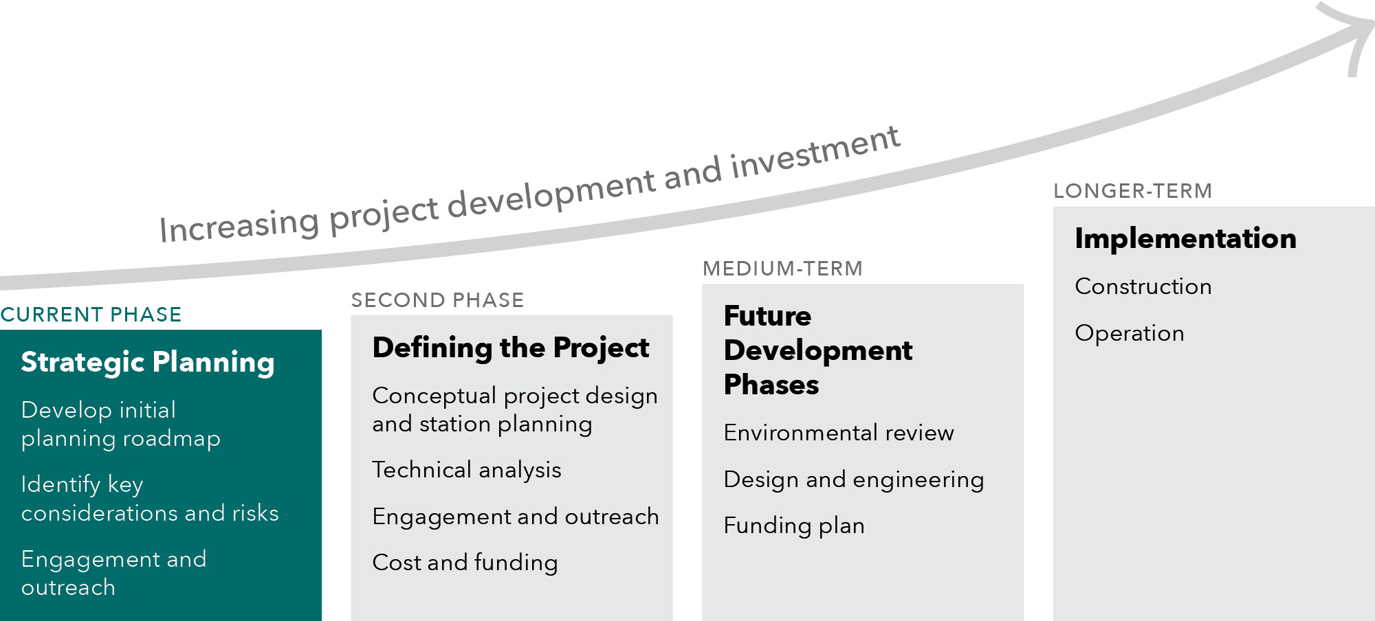
The development of the Geary/19th Ave Subway will be a complex multi-phase process spanning multiple years, as illustrated in Figure 1-1. This report supports the robust decision-making that is required to both realize project benefits and manage the cost and complexity of developing a new subway. It is divided into six chapters that guide readers through relevant background information, initial planning work, project performance, essential building blocks, conclusions, and next steps.
|
Chapter |
Content Included |
Questions Explored |
|---|---|---|
|
1. Introduction |
Introduces this report, including background on why this work was completed, context on the Geary/19th Ave Subway, and the role of this study in the ongoing development of the project |
|
|
2. Issues & Opportunities |
Explores the issues, challenges, and opportunities on the Geary/19th Ave Corridor to identify an overarching rationale for a potential subway. These findings set the frame for the design options explored in Chapter 3 and the metrics that are used to evaluate the case for the project in Chapter 4. |
|
|
3. Subway Design Options |
Defines a set of representative options based on key design choices for the Geary/19th Ave Subway: how and if to connect the subway to the regional rail network, what markets to serve, and the technology to use for the project. These choices are used to define a range of design options that are evaluated in Chapter 4. |
|
|
4. Project Performance |
Evaluates the representative options defined in Chapter 3 to understand the overall potential performance of a Geary/19th Ave Subway and identify any initial trade-offs of different design choices. This chapter is not intended to select an alternative; rather it presents an envelope of performance for the Geary/19th Ave Subway to make the case for the project and inform future design work. |
|
|
5. Other Key Building Blocks |
Describes other key elements required to successfully advance and deliver the Geary/19th Ave Subway, including strategies to attract/develop funding and optimize project benefits in the communities it serves. |
|
|
6. Conclusions & Next Steps |
Summarizes the previous chapters into a set of conclusions and recommendations for the Geary/19th Ave Subway and outlines a process and next steps to advance the project. |
|
The Geary/19th Avenue Subway, as identified in the ConnectSF Transit Strategy (2021) and the 2050 San Francisco Transportation Plan (2022), is envisioned as a rail rapid transit subway oriented under Geary Blvd and 19th Ave in San Francisco. Prior work has left several open design questions, such as project termini, specific routing in Downtown San Francisco and in the transition between Geary Blvd and 19th Ave, and rail technology. This study has advanced initial understanding of these design considerations. Other project attributes, such as specific station locations and configurations, will be explored in subsequent phases of project development.
The Geary/19th Avenue subway corridor begins in Downtown San Francisco near the Salesforce Transit Center. It continues west through the Western Addition extending potentially as far west as the Inner Richmond, connecting these neighborhoods with regional high-capacity rail. It turns south through Golden Gate Park and continues beneath 19th Avenue connecting the Sunset, Ingleside, Parkmerced, and other nearby neighborhoods. The corridor continues to northwestern San Mateo County, terminating roughly near the existing Daly City Bay Area Rapid Transit (BART) station, with connections to the BART network. The corridor is illustrated in Figure 1-2.
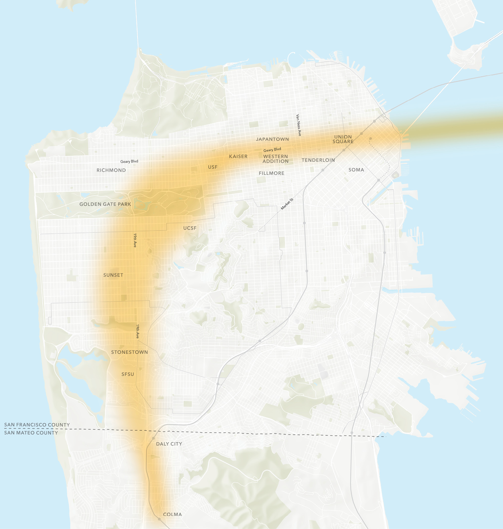
For the purposes of this analysis, the Geary/19th Ave Corridor encompasses the neighborhoods and destinations approximately ½ mile from Geary Blvd and 19th Avenue in San Francisco, excluding portions of the downtown area (east of Van Ness Avenue) that are well served by transit today.
Chapter 2 explores the opportunities, issues, and challenges currently facing San Francisco and the Bay Area with respect to the Geary/19th Ave Corridor and anticipates what the impacts could be if they are not addressed.
The Geary/19th Ave Corridor is critically important for moving people and goods across San Francisco and the wider Bay Area. A Geary/19th Subway provides the opportunity for a high capacity, fast, frequent, and reliable transit service across the corridor and beyond. It can help meet future travel demand, support planned housing development, and better meet the evolving needs of San Francisco and the Bay Area.
Today, the Geary/19th Ave Corridor is home to nearly 29% of San Francisco’s population, 43% of its jobs, and many significant employment, cultural, academic, and social service centers and institutions. Communities along the corridor are anticipated to grow significantly in the coming decades. Population growth planned for in San Francisco’s 2022 Housing Element reflects 100,000 new people and 80,000 new jobs along the corridor.
Travel demand on the corridor is significant. Each day hundreds of thousands of trips are made to places along the corridor or to access other parts of the Bay Area. This high level of travel demand can make transit crowded and roads congested, resulting in slow and unreliable travel times.
Recently, substantial transit priority investments along Geary Boulevard and 19th Avenue have improved reliability along the congested surface network. However, they do not always provide competitive travel times for trips across the entire city or to key regional destinations elsewhere in the Bay Area, nor do they provide the capacity needed to serve future demand. The improvements required to meet these needs are not achievable solely with at-grade transit service. A new grade-separated rapid transit service — a subway — is needed to provide reliable, fast, frequent, and comfortable mobility and to support the growth expected along the Geary/19th Ave Corridor.
Several investments in Geary Boulevard over the last several years have helped to increase bus travel times, improve reliability, and match service to demand.
The Geary Rapid Project, completed in 2021, added new transit lanes, transit signal priority, optimized bus stop locations and bus bulb-outs on Geary Boulevard east of Stanyan Street. These improvements decreased travel times by 18% and improved on-time performance by 37%.
The SFMTA also installed transit lanes west of Stanyan to 32nd Avenue through the Geary emergency transit lanes project (completed 2021) and the Geary Boulevard Improvement Project’s Quick-Build phase (completed 2023). Additional improvements, including paving, colored lanes and bus bulb-outs, will be completed by 2027 and extend those benefits to the Richmond District as far as 34th Avenue.
In addition, the 28 19th Avenue Rapid Project has introduced transit priority treatments including transit signal priority, bus stop consolidation, and wider sidewalks with bus boarding areas that have worked together to improve 28 and 28R speed and reliability.
Even with bus service optimization along both corridors, however, transit journeys along Geary Boulevard and 19th Avenue can range from 45 – 60 minutes or more and include one or more transfers.
The opportunity statement for the Geary/19th Subway project summarizes the key transportation and related policy issues faced by people who live, work, study, visit, and travel along the Geary/19th Ave corridor today and in the future. Through a review of existing and future levels of travel demand, the study team identified three overarching goals for the Geary/19th Ave Subway:
Table 2-1 provides a summary of these opportunities and the challenges identified in achieving them. The following sections provide more detail on each Opportunity and Challenge.
In recent years, significant investments have been made to improve surface (bus) transit in the corridor. These investments have included the Geary Rapid Project and the Geary Boulevard Improvement Project, as described above. In the future, and as the corridor and region continue to grow, grade separated rail transit — a subway — will be needed to take service to the next level of capacity, quality, and consistency while providing faster and more direct journeys. Current conditions along the Geary/19th corridor sometimes do not meet traveler needs today, and with anticipated growth, will not meet traveler needs in the future. Two key challenges illustrate this need:
Without improvement, by 2050:
Significant growth is planned along the corridor, and travel patterns will evolve as changes occur with respect to where people live, work, and travel. Growth will put increased strain on transit infrastructure and service that cannot be fully accommodated with today’s network; this could result in greater crowding, congestion, and increased Vehicle Miles Traveled (VMT) that would make realizing this growth more challenging. The corridor is also home to major universities, hospitals, cultural institutions, and employment areas; however, it is not fully connected to the rest of San Francisco and the region, which constrains economic opportunities. Two key challenges illustrate this need:
Environmental protection is a long-standing regional and statewide goal that requires a full complement of strategies to address — from land use and transportation to electrification and decarbonization. A Geary/19th Ave Subway would play an important role in contributing to these strategies. The following challenge illustrates this need:
The opportunities and challenges described in this chapter were used by the study team for the development and assessment of potential project choices, with consideration of implications for transit riders, communities in San Francisco and northern San Mateo County, and the wider region. Each opportunity was also considered with an equity lens, with analysis to understand the magnitude of benefits realized by residents of Equity Priority Communities (EPCs).San Francisco’s Equity Priority Communities include a diverse cross-section of populations and communities that could be considered disadvantaged or vulnerable now and in the future. Equity Priority Communities can have high levels of households with minority or low-income status, seniors, people who have limited English proficiency, people who have disabilities, and more. For more information on how Equity Priority Communities are defined and to explore a map of their locations, see https://www.sfcta.org/policies/equity-priority-communities
Planning work completed for this phase aimed to describe an “envelope of performance” with respect to the set of metrics that illustrate the project’s effectiveness in addressing the challenges. These metrics were used to evaluate the potential subway in Chapter 4, both to make the case for the Geary/19th Ave Subway, and to explore how different alignment choices and other scope choices impact the benefits of the project.
The analysis in this phase — both in establishing the challenges and opportunities and evaluating project performance, is based on the best available assumptions for long-range forecasts. These analyses should be revisited as the project continues to develop to ensure that the project still addresses the challenges and delivers benefits effectively, to justify entering future phases of work and committing the additional resources required to do so.
The Study has preliminarily identified potential major subway design features and key tradeoffs in configuration, performance, and relative cost. Analysis and decisions about alternatives will be made in subsequent phases of study, but a preliminary assessment of high-level tradeoffs by project segment are explored in the sections below.
Building on the high level, conceptual project definition laid out in the ConnectSF Transit Strategy, the study team identified major design choices for the subway and how each could result in potential tradeoffs that will need to be addressed or resolved in subsequent project phases. Through a series of workshops with agency (SFCTA, SFMTA, and SF Planning) staff, the study team identified three key topics of consideration to inform the potential universe of alternatives for a Geary/19th Ave Subway:
These questions are often interrelated and overlapping, and optimizing across them will require refinement of technical tradeoffs and coordinated decision-making as the project advances through further development.
This phase of work has examined an initial range of routing and station location considerations across the corridor, as well as in three focused areas within the corridor:
The sections below discuss the key choices, benefits, and tradeoffs associated with each segment of the subway.
Both the ConnectSF Transit Strategy and the 2024 California State Rail plan envision the Geary/19th Ave Subway as an important link in the Bay Area and Northern California rail network, and this future western San Francisco opportunity has been highlighted in the Link21 Market Analysis and the State Rail Plan. By connecting western San Francisco to and from the broader region, via a new transbay rail crossing to the East and integration with existing rail extending to the south, the subway would bring direct regional rail service to some of the densest and fastest growing portions of the region over the coming decades.
To this end, this study considered modes that could deliver frequent, high capacity metro-like service in the corridor while also being interoperable and allowing through-running with one of the two primary modes of regional rail operating in the Bay Area today:
Other rail technologies could potentially meet the capacity and frequency requirements of the corridor while requiring a transfer to access the broader regional rail system. These other options include Muni LRV (Muni Metro) technology and automated light rail transit or ALRT (which has been implemented in Vancouver, BC, among other regions). Rail technology options and their implications for the project are described further in Section 3.1.6, below.
Achieving regional connectivity will require the alignment of technology choices, as well as ongoing coordination, with other efforts, including Link21, The Portal, and the State Rail Plan. Certain technology decisions made by other projects may constrain the set of choices for routes, station locations, and other project attributes available to decision-makers in future phases of planning. For example, while it may be possible to through-run standard-gauge regional rail trains from the East Bay to the Geary/19th Subway, it is unlikely that they would be able to continue into San Mateo County without significant additional expense and disruption due to the lack of an existing standard-gauge alignment along the western Peninsula.
In June 2025, the Link21 project team recommended Standard Gauge rail as the technology choice for the new rail crossing of the Bay. For the purposes of this strategic case, we evaluated the potential of both BART and Standard Gauge technology options in the crossing to consider the technical, performance, and strategic implications of each. As both projects continue to advance, ongoing coordination will be necessary to understand the potential benefits, costs, and trade-offs for how the two mega-projects could interface for users as well as for system owners/operators assessing operational/system impacts, funding, and constructability, among other implementation questions.
As one example of this decision-making complexity, the ability to connect to the rail system outside of San Francisco will be an important consideration when determining the size, shape, and location of the vehicle storage and maintenance facility or facilities that would be needed to support service. A fully interconnected system could potentially leverage existing or expanded regional storage and maintenance facilities, or take advantage of co-location opportunities in coordination with other projects (such as a new transbay crossing). Potential sites for a new facility within or adjacent to San Francisco are relatively limited but should also be considered in a future study phase.
The Geary/19th Ave Subway is envisioned to provide high capacity, frequent metro service that would be supported by bus services connecting to and supplementing transit capacity in the subway corridor, similar to the Mission, Market, and Central Subway corridors.
Across the corridor, decisions regarding station locations and station spacing will correspond with the technology selected and as such, the options involve tradeoffs between station spacing, design/travel speed, fleet maintenance requirements, and costs of construction and operation. Based on existing and planned densities of housing, population, jobs, and other attractions, the subway alignment and station plans could vary but the study team anticipated stop spacing between 0.5 and 1 mile, in line with the ranges currently seen on the BART system within San Francisco (approximately 0.5 miles on the Mission corridor, and approximately 1 mile between Glen Park, Balboa Park, and Daly City). Each station comes with significant cost to construct, and all stations on the project should be transit supportive in terms of access and land use, with thoughtful planning to mitigate risks of displacement and community instability.
The Geary/19th Ave Subway’s configuration and routing through Downtown San Francisco is closely related to the policy choices that must be made regarding regional interoperability and integration discussed above. Should through-running of trains to the East Bay be a priority, the project will need to develop an integrated approach with the Link21 program’s new transbay crossing.
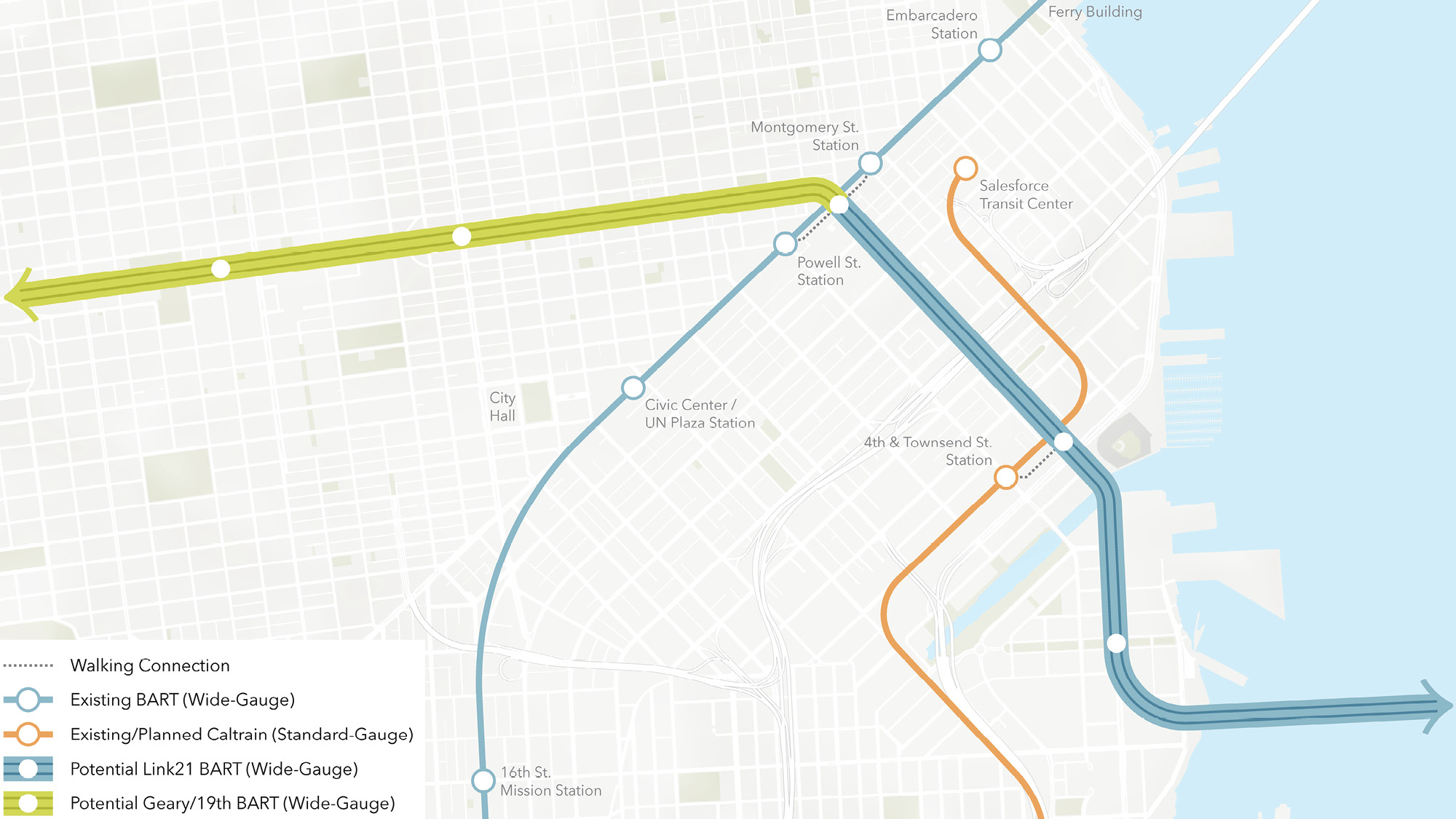
If a new transbay rail connection is routed via Mission Bay and 3rd Street terminating near Market Street, as shown in Link21’s representative concept for BART technology, the Geary/19th Ave Subway would likely continue straight west under Geary Blvd towards Van Ness, the Western Addition and Japantown. This option would provide a slightly shorter travel time than the Howard Street / Salesforce Transit Center alignment described below, and passengers could connect to the existing Market Street subway at Powell/Union Square or Montgomery, as well as to the Salesforce Transit Center with a short walk. This configuration is illustrated in the figure below, with Green representing the Geary/19th Ave Subway using BART technology and Blue representing Link21 BART technology subway.
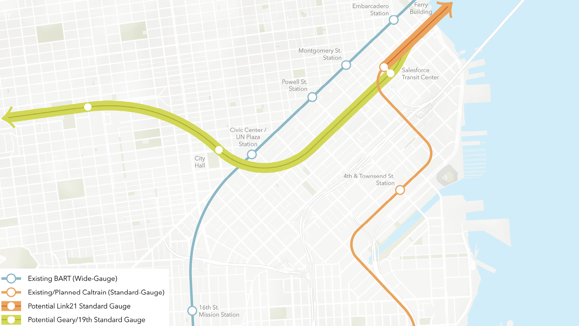
If a new transbay rail connection is routed via Howard St terminating at or around the Salesforce Transit Center, as shown in Link21’s representative concept for a standard gauge regional rail technology, the required depth and tunnel turn radii would likely require a routing via the Civic Center station area before turning back north towards the Western Addition and Japantown. Additionally, this option would likely require the construction of additional underground platforms at or near the Salesforce Transit Center, which could prove challenging in the built-out urban environment, above and below ground, in this area. This option would provide a slightly longer travel time than the Mission Bay / 3rd St / Geary Blvd alignment described above, but would enable direct service to the concentration of residents and jobs near Civic Center. Passengers could connect to the Market Street subway and Van Ness BRT at the Civic Center station, and downtown passengers could connect to the Salesforce Transit Center or to Montgomery or Embarcadero stations with a short walk. This configuration is illustrated in the figure below, with Green representing the Geary/19th Ave Subway using Standard Gauge Regional Rail technology and Orange representing a Link21 Standard Gauge Regional Rail subway.
ConnectSF identified a broad area in which the connection could be made between the portion of the subway under Geary Blvd and the portion under 19th Ave, contemplating turning south between Masonic and Park Presidio, based on demand, land use, cost, and constructability considerations. While there are numerous discrete options that could be available within these bounds, a set of key tradeoffs has emerged to illustrate the choices at hand in this area.
By hewing more to the east, potentially turning at or near Masonic, the subway could directly serve areas with existing established residential density, such as Japantown and the Western Addition, Kaiser Hospital, and important regional destinations like the University of San Francisco and UCSF. These areas, however, are also already served by a higher density of transit than points further west, and enjoy relatively short travel times to and from Downtown today.
By continuing further west under Geary Blvd before making a turn, the subway would have the opportunity to directly serve areas not well linked to regional transit today, shortening journey times to and from the Richmond, as well as to important regional destinations like Japantown, the Western Addition, Kaiser Hospital and the University of San Francisco, as all alignments would. A number of options in the middle would serve housing growth areas while still enabling faster regional connections to places like Golden Gate Park, the Inner Sunset, and UCSF, all of which draw regional visitors and local trips.
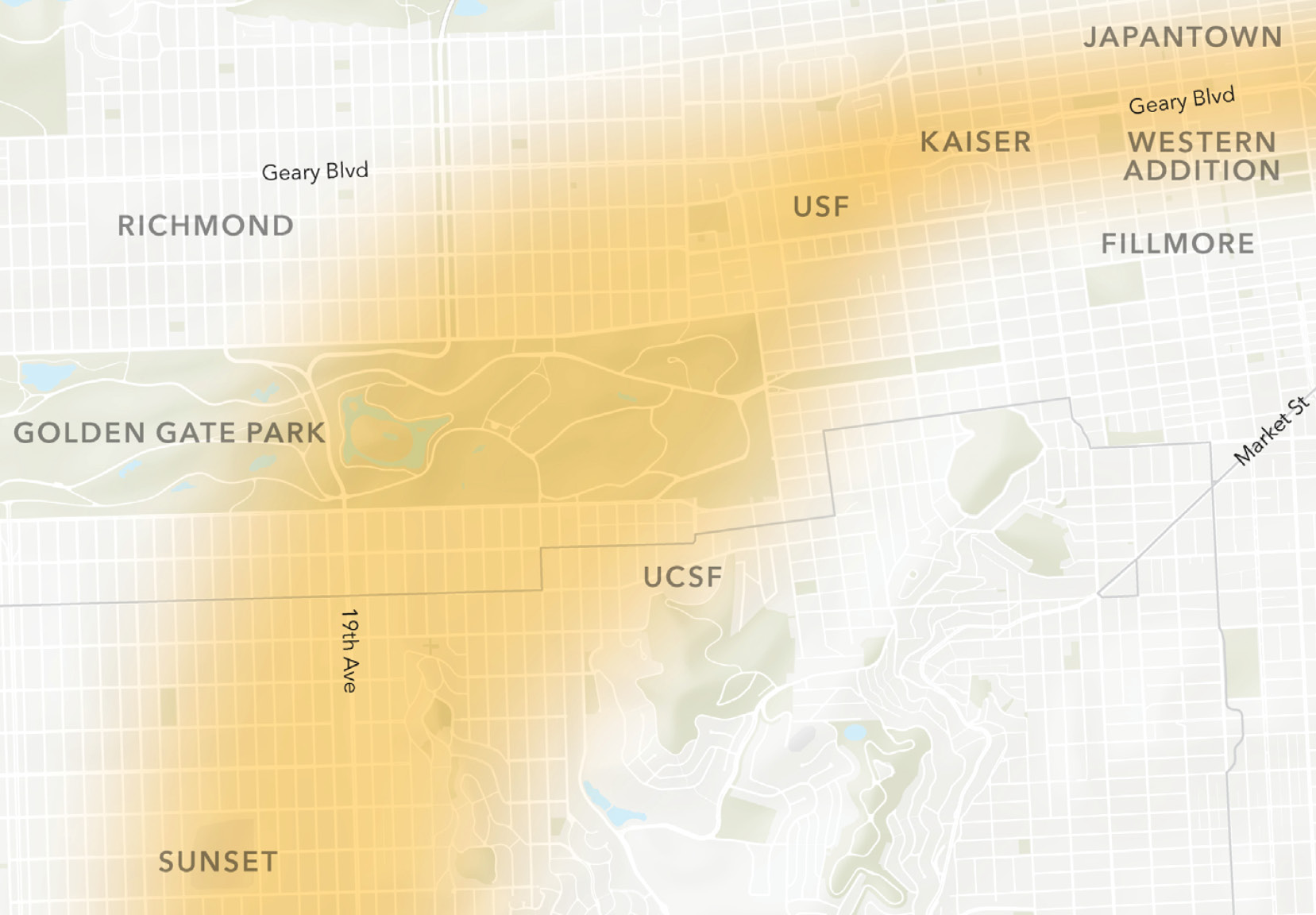
Regardless of the eventual final alignment, it will be important to advance the project in concert with continued citywide and neighborhood planning efforts. Subways are a major public investment, and supportive land use maximizes their ridership and benefits. On the whole, San Francisco’s plans to deliver more housing and increase affordability and accessibility create a clear need for enhanced transit options in the project corridor.
In assessing potential options in this part of the corridor, the project team should consider the full transit network and connecting bus services, including Muni and Golden Gate Transit. While a new subway may not directly serve a neighborhood or destination, it would still reduce travel time, crowding, and delay for transit riders on and off the corridor, by offering the opportunity to transfer to a faster and more reliable service to complete the trip (or the option to do so at a closer location than may exist today). For example, trips beginning west of 19th Avenue and heading towards the East Bay would have the opportunity to transfer to regionally connected rail along Geary itself, rather than remaining on surface bus or light rail transit all the way to Market Street and the Salesforce Transit Center, as they would today.
The approach to connecting the Geary/19th subway with the regional rail network (BART) near the San Francisco/Daly City border will be driven by both technology choices and topography.
A technology choice of BART for the project would allow trains serving the Geary/19th subway to continue along the existing BART alignment south to San Francisco International Airport and Millbrae for a connection with Caltrain and future California High-Speed Rail service. A standard gauge regional rail option, or the Muni Metro or ALRT options, would require a passenger transfer at or around either the Daly City or Colma stations. These technologies would also narrow the options for the siting and configuration of the required supporting maintenance facility, which are not yet determined.
The topography of the southern terminus location also presents a tradeoff between a seamless transfer and an entirely “subway” configuration. The existing Daly City station is elevated, and given the topography heading north on the existing BART line, changes to this configuration would be challenging. As such, it is likely that both through running and transfer options for the Geary/19th Subway would need to surface and transition to an elevated alignment near the 19th Ave / I-280 freeway interchange before crossing into Daly City. It is possible that the need for this new structure could be reduced by designing transfers at or around the existing Colma station, but the costs of this approach may be prohibitive, including potential impacts to BART’s storage and maintenance yard at the Colma station.
The Geary/19th Ave Subway Opportunity Statement (presented in Chapter 2 of this report) identifies the need for frequent, high-capacity metro-like service in the corridor. The study team reviewed multiple rail-based technologies that could meet this need. Four options were identified:
Rail technologies differ in several other important ways that influence scope, including cost and operations and maintenance facilities, as shown in Table 3-1.
Technology choice is interrelated with decisions made for interoperability and through-running services. For example, while it may be possible to through run standard gauge regional rail trains to the Geary/19th Ave Subway, they would not be able to continue into San Mateo County without significant additional expense.
Each technology can be deployed to provide a similar speed, capacity, and level of service in a unique way, with trade-offs on capital and operating costs. For example, a Light Rail or ALRT system may have shorter trains but offer higher frequency to achieve a similar capacity when compared to a BART or standard gauge system that may use longer trains operating less frequently.
As discussed in Section 3.1.1, the choice of technology and its relationship to existing networks will also have bearing on the potential location and size of the subway’s operations and maintenance facility, which will be required in order to provide service. Available sites for this facility — estimated to require 10 – 20 acres of level ground accessible from the subway — are extremely limited in San Francisco and Northern San Mateo County. The choice of technology could affect the project’s ability to leverage existing sites, depending on through-running configuration.
The study team developed high-level, rough order of magnitude cost estimates encompassing the range of design considerations described in this chapter. Based on anticipated and actual costs of recently completed or funded peer rapid transit subway projects in California and North America, the initial cost estimate range is intended to be indicative of potential capital costs, and was used to inform the overall findings of this current study and subsequent phases of project development.
Based on these factors, the capital cost for the Geary/19th Ave Subway, including design and engineering, is estimated to be in the range of $20 billion to $30 billion in 2026 dollars. Key people driving of this range are per-mile tunneling and per-station construction costs; the estimates provided in this phase do not include supporting facilities, right-of-way, financing costs, or escalation.
A project of the scale, scope, and cost of the Geary/19th Ave Subway will need to consider how to potentially phase implementation (and thus, costs and funding needs) over multiple years. Subsequent project development efforts should consider the definition of a potential initial operating segment with independent utility. These initial segments could bring project benefits to travelers and communities sooner, while also preparing the full project for completion. This phasing assessment should also consider the cost and funding implications of any potential phased approach. For the Geary/19th Ave Subway project and corridor, future choices regarding train technology and regional integration will shape the range of potentially viable phasing options.
This chapter explores the benefits of the Geary/19th Ave Subway and core building blocks to advance. It presents findings across a range of design choices, as explored in Chapter 3, to show the potential envelope of performance of the project and illustrate how the design choices may influence that performance.
The design choices discussed in Chapter 3 were used to develop a set of Conceptual Design Options for analysis. Importantly, these Conceptual Design Options are not ‘alternatives’ for a Geary/19th Ave Subway for review and decision-making. They have been developed at a high level suitable for this strategic case, including:
The Conceptual Design Options included a San Francisco only subway alignment, with no regional integration beyond a passenger transfer, which tested both downtown alignments discussed in Chapter 3 as well as various options for the turn between Geary Blvd and 19th Ave. The top performing San Francisco-only alignments were then tested with through-running to San Mateo County only, through-running to the East Bay-only, and finally, through-running to both San Mateo County and the East Bay.
Because the performance of each technology can be optimized to deliver similar travel times and service levels along the corridor, this study’s analysis utilized a representative set of operational characteristics (frequency, speed, dwell times) to reflect rail rapid transit service in the corridor and the project’s broad performance. Specifically, depending on the exact design option, the analysis assumed:
All benefits included in this case are evaluated qualitatively and quantitatively using:
This analysis is included to illustrate the potential envelope of performance for a Geary/19th Ave Subway, based on the Conceptual Design Options. Future analysis will include updated benefits based on additional forecasts and design work, including further analysis of benefits required in regional, state, and federal government funding applications and grants.
In light of the generational investment represented by a subway, this study utilized long-range planning assumptions consistent with recently adopted land use policies. All analysis conducted for the Strategic Case used growth forecasts from the 2022 Housing Element Update’s Environmental Impact Report. These forecasts reflect the delivery of 82,000 new housing units in San Francisco, and the study's analysis assumed the recovery of ridership from the COVID-19 pandemic. The forecast assumptions used reflect adopted city policies and are appropriate for assessment of the magnitude of benefits a long-term investment like a subway would provide. Future project phases will continue to update these assumptions over time, in coordination with local, regional, and state level plans and policies.
The study team evaluated the performance of the Geary/19th Ave Subway, and the potential design options discussed in Chapter 3, against a set of metrics developed to illustrate how and to what extent the project would address the opportunities and challenges and deliver the benefits identified in Chapter 2. Full metrics are provided in the Geary/19th Ave Subway Performance Analysis Technical Memorandum, and are summarized below:
The Geary/19th Ave Subway has the potential to contribute significantly to improvements across the project’s three key goals:
The following sections will explore the results of the analysis in more detail. Key project benefits, and illustrative results, are summarized below:
The Geary/19th Ave Subway drives significant ridership increases and is anticipated to deliver a well-used service. A San Francisco-only alignment, without through-running to regional destinations, would serve up to 182,000 daily riders, of which up to 71,000 are net new trips. Decisions about routing within San Francisco such as where to terminate downtown and where to transition south from Geary to 19th Avenue have minimal impact on overall ridership. A regionally connected service could further increase ridership (Table 4-1):
This analysis suggests that a stand-alone San Francisco only Geary/19th Ave Subway would transform how people move within the city and region. The inclusion of connections to East Bay has the most significant impact on project performance and could nearly double ridership compared to a San Francisco only subway.
The Geary/19th Ave Subway could offer substantial reductions in travel time for Bay Area passengers, saving transit riders from 19,000 to 45,000 hours per day and reduce crowding experienced by transit users by 15 – 32%.
A San Francisco-only Geary/19th Ave Subway can reduce travel time by up to 20,000 hours per day across all travelers who make use of it. For example, transit trips to/from Western SF neighborhoods see significant travel time reductions:
Design choices on the alignment, such as where to turn between 19th and Geary and the downtown alignment have minimal impact on travel time benefits and crowding relief.
However, providing through-running service to the East Bay offers the most significant benefit to travelers:
Because of the growth in transit ridership noted above, and the reduction in Vehicle Miles Traveled (VMT) discussed in Section 4.3.4, a Geary/19th Ave Subway also has the potential to deliver benefits for people driving, though these effects are relatively small. The Study found modest travel time benefits and some reductions in vehicle delay during peak periods. For trips by car within San Francisco during peak periods, travel times may decrease by up to one minute per trip.
The Geary/19th Ave Subway would improve transit job accessibility for San Francisco and Bay Area residents — the average San Francisco resident could access up to 47,000 more jobs in 45 minutes by transit, while the average Bay Area resident could access up to 10,000 more jobs in 45 minutes. Equity Priority Communities (EPCs) see a more significant gain — access to 76,000 more jobs for the average EPC resident in San Francisco (60% more than the average San Francisco resident) and 18,000 more jobs for the Average Bay Area EPC resident (80% more than the average Bay Area resident). With through-running to the East Bay, residents of EPCs in San Francisco would see a further 10% increase in jobs access.
An East Bay connection using BART alignments allows for up to 59,000 more jobs within 45 minutes for priority San Francisco workers, while a connection using regional rail alignments could improve accessibility to 76,000 jobs within 45 minutes (Table 4-2).
The Geary/19th Ave Subway would result in significantly faster travel times and greater connectivity between relevant economic centers.
The Geary/19th Ave Subway would introduce high-capacity transit to areas of western San Francisco along 19th Avenue that are currently not well connected to the regional transit network and improve existing service along the congested and crowded Geary Blvd. Neighborhoods such as the Richmond, Sunset, and Outer Sunset see large reductions in time to destinations on the eastern side of the city and, with regional connectivity, the East Bay.
Major trip generators such as university campuses, shopping centers, and San Francisco International Airport (SFO) also benefit from steep reductions in travel time, in particular for East Bay destinations. For example, for the regional rail alignment options, trips to and from Emeryville would see an average reduction in travel time of roughly 30 minutes for destinations across San Francisco, roughly 35% percent faster (Table 4-3)
Design choices within San Francisco will also have an impact on travel time savings — and what trips benefit most from them — including the choice of route through downtown and how the subway connects between Geary Blvd and 19th Ave.
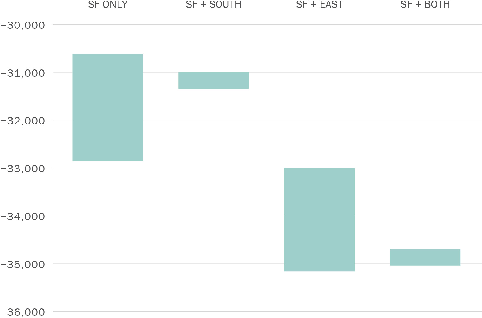
A Geary/19th Ave Subway could reduce greenhouse gas (GHG) emissions by 23,000 to over 35,000 tons per year, depending on the degree of electric vehicle uptake for private vehicle use.
Figure 4-1 presents the range of GHG reductions expected for each reference conceptual alignment. This range includes both design variations as well as adjustments for different levels of ZEV adoption, including for baseline, low EV, and high EV scenarios.
Preliminary modeling suggests only minor changes in GHG emissions between scenarios. In general, through running service to the East Bay offers higher ridership, and therefore greater Vehicle Miles Traveled (VMT) and GHG reductions. However, the most significant contributions to GHG reductions occur in San Francisco.
Download chart data (CSV)
A Geary/19th Ave Subway could reduce vehicle miles traveled in San Francisco by approximately 400,000 miles per day, or a 4% reduction, versus a future without the project. Regionally connected scenarios could see even further reduction, up to an additional 50,000 miles per day within San Francisco, for a total of 450,000 miles per day.
Some areas of San Francisco demonstrate greater rates of behavior change. In terms of VMT per capita, the biggest shifts occur in neighborhoods with already low to moderate rates of vehicle dependency, though Southwestern San Francisco, which has the highest rates of VMT per capita in the city today, sees a reduction at or slightly above the citywide percentage in the best performing scenarios:
Regional connectivity options offer the biggest shifts in VMT per capita across all neighborhoods.
A Geary/19th Ave Subway would support local, regional, and state goals for air quality. The study converted VMT reductions into local air pollutant equivalents on an annual basis using the California Air Resource Board’s guidelines. These pollutants include:
Pollution varies as a function of VMT reduction — alignments with greater VMT reduction would have stronger pollution reduction. Accordingly, project scenarios that include through-running to the East Bay have the most significant impact on pollution (Table 4-4).
The Geary/19th Ave Subway is one of five major transit expansion projects identified in San Francisco’s Transit Strategy (2021). The Transit Strategy is a key blueprint within the overarching policy framework set by the long-range San Francisco Transportation Plan (SFTP), most recently adopted in 2022.
The SFTP calls for an integrated approach to developing San Francisco’s transportation system, including through investment in the transportation system, development of new revenues, and advancement of demand management strategies including pricing. Within this framework, the Geary/19th Ave Subway is an important component of an integrated strategy to achieve San Francisco’s transportation goals and meet state and regional policy requirements. In turn, the benefits of the Geary/19th Ave Subway will be amplified through supportive policies, some of which would be anticipated to play a role in the project's funding strategy. Put simply, the viability and benefits of the project are linked with the continued progression of initiatives to manage San Francisco's transportation system and to develop new sources of funding.
Consistent with the SFTP’s policy framework, this section describes a set of other key building blocks for the Geary/19th Ave Subway. These factors were informed by an examination of peer projects in San Francisco and California, as well as other recently planned and delivered subway projects in North America and beyond. Particularly important, as discussed in this chapter, are the set of potential value capture and pricing strategies which would support project benefits and in some cases could yield revenue. While this study does not recommend the specific approach to advancing these building blocks, it does conclude that they should advance as part of or in parallel to the next phase of the project. The decision to advance the subway to future stages of development should consider these opportunities to develop and attract innovative approaches to project development, funding, and delivery.
An urban rail transit project such as the Geary/19th Ave Subway is a large, complex public investment. Existing local, regional, state, and federal funding sources are not sufficient to fully fund the project, which has an initial cost estimate range of approximately $20B – $30B in 2026 dollars, as discussed in Chapter 4. The project has the potential to drive significant value creation in multiple areas (such as travel time, land value, economic development, and environmental quality). The study team identified potential mechanisms to return a part of this value to the project, helping to support its funding plan. It is important to begin exploring these mechanisms in parallel with early planning, to inform further development of the funding strategy and advancement of specific funding sources during future phases of work.
This study developed an initial set of key considerations to inform the development of the project’s funding strategy:
San Francisco, the Bay Area, and the State of California have a history of developing innovative funding approaches in order to make generational investments in our transportation system. Drawing a nexus between the value the Geary/19th Ave Subway would create and potential sources of funding is an initial step in considering these new funding options. For example, transportation projects that significantly increase accessibility and reduce travel times can contribute to uplift in land values. Table 5-1 below shows some potential value capture strategies for consideration as the project’s funding plan is developed.
Multiple projects in San Francisco have benefited from value capture to contribute to their funding plan and delivery. Recent examples include:
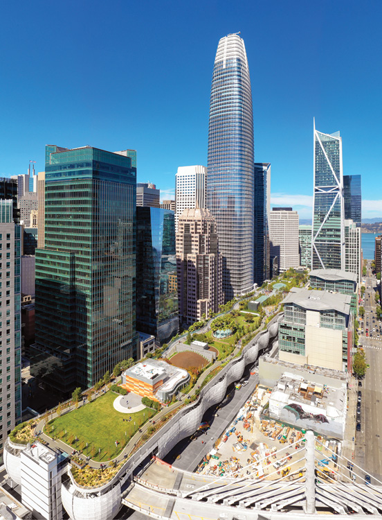
The Salesforce Transit Center is San Francisco’s regional transit hub. The Transbay Joint Powers Authority (TJPA) utilized multiple techniques to contribute about half of the funding plan for the Transit Center itself. Specifically, the project funding plan included in part:
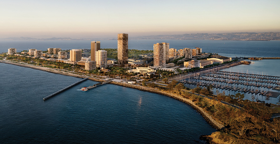
By 2042, the Treasure Island neighborhood will grow by up to 8,000 homes — many offered at below-market rates — housing more than 20,000 new residents. The Treasure Island Mobility Management Agency is developing a comprehensive transportation framework that will meet the current and future needs of residents, workers and visitors to ensure a vibrant community. Among other sources, the full funding plan for the transportation framework anticipates making use of:
Subsequent phases of work should include the development of an indicative funding plan for the project, reflecting the ranges of potential funding from existing and new sources. This plan should include initial revenue range analyses for a range of potential new sources, developed to an order-of-magnitude level, with a focus on the sources that could harness the value created by the project, as described above. Development of this indicative funding plan will also require coordination with other related efforts, such as pricing studies, travel demand management initiatives, and regional and statewide rail planning and development efforts. Future phases of study will also seek and include input on potential funding strategies from members of the public and policy-makers.
In addition to technical work, engagement with residents, businesses, institutions, and community stakeholders will continue to be essential to advancing project development for the Geary/19th Ave Subway. This study included public outreach activities, to identify key interests and potential concerns of community members. Future phases will also include public engagement efforts, as specifics about the subway and its design, construction, and operation come into better focus. As discussed in Chapter 4, significant project decisions, while informed by technical analysis, will be guided by input from stakeholders and direction from elected officials — in particular, the project’s routing and station locations along the corridor.
For this phase of work, the study team conducted two rounds of outreach using online town halls, focused on surfacing community interest and questions and sharing the results of the preliminary analysis. The study team also presented directly to interested neighborhood groups and other community based organizations, and hosted an online survey which received over 2,400 responses. The feedback at both in-person and online events, along with the survey, was consistent: respondents broadly understood the need for a Geary/19th Ave Subway, and were interested in exploring ways to deliver the project more quickly and at lower cost. Some community members raised questions about potential construction methods and disruptions related to construction to both residents and businesses. These questions will be addressed in more detail in subsequent project stages, as detailed in Chapter 6.
Potential indirect displacement resulting from new transit investments is both a real and perceived concern for residents and small businesses who live near proposed transportation projects. Depending on local conditions, improved accessibility or services resulting from such investments can drive up land value, increase rents, and potentially displace existing tenants without protection policies in place. Ultimately, the intention of major transit investments is to improve access to opportunities — like jobs, education, healthcare, recreation — for those along the project corridor and beyond.
While a future Geary/19th Ave Subway project would not be the only force driving displacement pressures in San Francisco, research shows that new transit investments can contribute to market trends that may already be impacting neighborhoods. The subway project would serve as a catalyzing opportunity to put into place additional anti-displacement tools and to support existing residents in benefiting from the improved access provided by the project in the future. Developing a proactive approach to address indirect displacement early is critical. In practice, this means building a deep understanding of neighborhood conditions — including to identify opportunities to tailor and apply specific anti-displacement strategies within the neighborhoods along the project corridor. This work will also require community engagement and outreach, to inform and guide anti-displacement efforts over time.
At the time of writing, San Francisco currently employs almost 30 residential anti-displacement tools, and over 20 commercial anti-displacement strategies. These strategies are an integral part of San Francisco’s efforts to address and maintain affordability for existing residents and businesses. As part of this study, the San Francisco Planning Department compiled an analysis of these strategies, as well as other that have been used in peer projects, and identified which could be advanced by the project itself and those that would be better deployed on a citywide basis in parallel with development of a Geary/19th Ave Subway. The analysis and report is available as Geary/19th Ave Anti-Displacement Strategy Technical Memorandum.
Residential anti-displacement policies broadly fall into three categories: protection, preservation, and production. Existing San Francisco policies and programs are among those that research has shown to be effective in addressing potential displacement, including but not limited to:
San Francisco’s commercial anti-displacement policies also include a number of policies to assist existing and legacy businesses to remain in place. Some examples of these policies include:
A full list of strategies, and example programs within San Francisco, can be found in Geary/19th Ave Anti-Displacement Strategy Technical Memorandum.
The Geary/19th Ave Subway is one of five major rail and transit enhancements identified in the ConnectSF Transit Strategy (2021) and the 2050 San Francisco Transportation Plan (2022), San Francisco’s long-range planning document for the transportation system. Each project will require substantial funding to advance from concept to final construction and delivery. While these plans laid out the initial concepts of each project (see call-out box), they did not prioritize the order in which each should advance or be implemented.Though these plans did not conduct an analysis to prioritize amongst the long-range transit expansions included, each identified The Portal as a clear near term priority, given its advanced stage of project development and long-standing local and regional plan status. The Portal has been identified as a regional transit expansion priority since 1988 (MTC Resolution 1876), has progressed in the FTA funding process, and is already under procurement. Though the responsible agencies have the capacity to advance initial planning efforts for multiple projects in parallel, in the future San Francisco and its partners will need to make a determination on the sequence in which projects will advance, as subsequent phases of project development and design will require larger commitments of resources.
ConnectSF and the 2022 San Francisco Transportation Plan identified five major rail and transit projects with the potential to deliver significant benefits to San Francisco and the region. Each project is advancing independently on its own timeline. The five projects are:
Project prioritization is anticipated to begin with the preparation of the next major update to the San Francisco Transportation Plan (SFTP), SFTP 2060, which is planned to kick off in 2027. This plan will use updated information about each project’s performance, as well as other effectiveness and readiness criteria, to make recommendations regarding how and on what timeline San Francisco’s full vision of long-range transit and rail expansion should advance. Through the SFTP process, projects will be evaluated based on their impact with respect to the SFTP goals: equity, economic vitality, environmental sustainability, safety & livability, and accountability & engagement.
Major projects also need to be prioritized on a regional scale to be competitive for outside funding. The Metropolitan Transportation Commission (MTC) prepares Plan Bay Area, the regional transportation plan for the nine-county Bay Area, which will evaluate major projects from San Francisco and across the region. Eventually, project advancement for the Geary/19th Ave Subway will also require securing an endorsement for federal or state funds under the MTC’s Major Advancement Policy (MAP).
Based on the project performance profile described in Chapter 4, we expect the Geary/19th Ave Subway would be competitive under existing federal criteria for the Federal Transit Administration’s Capital Investment Grant Program. This program evaluates projects under two broad areas:
While San Francisco’s existing Prop L transportation sales tax provides limited funding for planning and project development of transit projects, additional local, regional, and state funding will need to be identified to demonstrate local financial commitment and support the full build-out of the subway.
As a subway, the bulk construction activity for the project will occur underground, helping to reduce disruptions to communities during construction. At the same time, construction at street level will be necessary, including for tunnel access, stations, and ventilation, among other elements. Input and concerns regarding the effective management of construction were also a consistent theme raised by the public during the study’s town halls and presentations with community organizations.
San Francisco has learned meaningful lessons from recent and current subway projects, including the Central Subway and The Portal, as well as other corridor-focused projects such as Van Ness BRT and the Taraval Corridor Improvement Project. For the Geary/19th Ave Subway, future stages of project planning will require careful design and community engagement, to develop construction-phase strategies that reduce and mitigate impacts to neighborhoods. The project should also consider the application of best practices for urban subway construction along busy corridors — for example, approaches that allow the construction of new stations below roadway decking to preserve the flow of street users, as has been used recently on LA Metro’s Purple Line (D) Extension Project.
This chapter summarizes the conclusions of this study, demonstrates the case for the Geary/19th Ave Subway, and identifies potential next steps.
This study has found that a grade separated, high capacity rapid transit investment is both needed and viable in the Geary Boulevard and 19th Avenue corridors in Western San Francisco. As future phases of the project are completed, significant project decisions will need to be considered related to regional integration, routing and station location, technology, and funding, in increasing levels of detail. Future phases will also more deeply explore the trade-offs among these decisions, informed by more robust engineering, planning, and cost estimation than was completed in this initial phase of work.
In summary, this study has found that:
The Geary/19th Ave Subway and Regional Connections Study is the initial step of a multi-year process by which a major transit capital investment is planned, environmentally cleared, designed, constructed, and eventually opened for passenger service. Projects usually proceed through multiple stages of development, with the conclusion of each supporting decision-making regarding the project’s readiness and worthiness to advance to subsequent stages. These broad phases of project development and implementation are summarized in Table 6-1 below:
Because major transit capital projects are complex undertakings involving many stakeholders, varied interests, and multiple approvals, it usually takes at least 15 to 20 years to progress from project initiation to revenue service. For a project of the scale and characteristics of the Geary/19th Ave Subway, approximate minimum timelines (subject to funding) for each major stage of project development are as follows:
Peer projects in California have typically spent a total of approximately 5 – 8 years in the Planning, Alternatives Analysis, and Environmental stages, followed by approximately 7 – 10 years for construction and commissioning. Projects moving more quickly through these steps typically demonstrate robust local and regional financial commitment, including through voter-approved funding measures, that enable project sponsors to secure necessary approvals and commitment of state and federal funding. Recently, there have also been efforts to streamline the environmental phase for certain transit projects; such opportunities could be explored in the future for the project.
In order to successfully advance a major capital rapid transit project such as the Geary/19th Ave Subway, there are three broad areas of focus that support the ability for progress over time:
Progressing to each stage of project development also requires the availability and commitment of funding to undertake the next stage of work. At present, limited project-specific funding for the project has been identified, and the immediate next phase of work (discussed below) is contemplated to include work to further explore promising sources of funding, develop an initial indicative funding plan, and engage with the public on key funding opportunities and tradeoffs.
The completion of Concept Development and Alternatives Analyses studies for the Geary/19th Avenue Subway are estimated to require approximately $10 million to $15 million, depending on the number of alternatives explored and level of engineering design required. The study has identified an initial set of prioritized Alternatives Analysis tasks that could be advanced with available funding — approximately $1.5 million in programmed half-cent sales tax funds, up to $3 million if the project is successful in securing competitive regional funding — in the near term. This work would also engage with community stakeholders and develop technical understanding to help narrow the universe of options under consideration.
The following technical and engagement task areas have been identified for potential incorporation into the immediate next phase of project development:
The inclusion of specific tasks within a next phase of work will be subject to available funding, including external grant funding from regional and state sources. An overall aim of the immediate next phase would be to undertake prioritized work that is supportive of subsequent completion of the full Alternatives Analysis stage, including preparation for the future Environmental Review stage.
The preparation of this report has been financed in part by grants from the Federal Highway Administration, U.S. Department of Transportation. The contents of this report do not necessarily reflect the official views or policy of the U.S. Department of Transportation.

 Download a PDF of this report