Image

The Inner Sunset brings together many of San Francisco’s greatest traits: excellent dining, grocery shopping, access to green spaces, and retail, all at a walkable, neighborhood scale. The neighborhood has an active and invested community of residents, workers, and visitors. City agencies and community members have collaborated in the past on a number of significant transportation projects, including transit upgrades, curb studies, and road closures in Golden Gate Park (GGP).
The Inner Sunset Transportation Study (“Study”) intends to build on this past work with a focus on leveraging community participation to inform future projects. The purpose of the Study is to identify safety and circulation challenges for stakeholders in the study area and define near-, mid-, and long-term recommendations to address those challenges. These concepts will be integrated with parallel studies and ongoing efforts, such as the Biking and Rolling Plan. The challenges and proposed solutions will be defined by both data analysis and community outreach that balance the needs of stakeholders including residents, merchants, workers, visitors, and local community organizations. A particular focus for this Study is prioritizing the safety of vulnerable road users, which are defined here as anyone outside of a vehicle (including those walking, biking, or rolling), and aligning with the city’s Vision Zero goal.
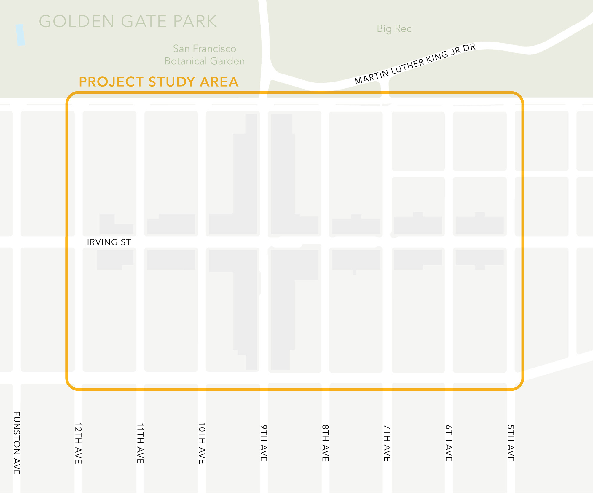
The study area shown in Figure 1-1 centers on the commercial district of 9th and Irving at the heart of the Inner Sunset and includes the surrounding blocks between Lincoln Way, 5th Avenue, Judah Street, and 12th Avenue.
The study area is within the larger Inner Sunset district of San Francisco, which had a total population of 37,630 as of 2023. Other statistics from the American Community Survey (ACS) 2020 – 2024 are reported in Table 1-1 and Table 1-2 for the larger Inner Sunset district.
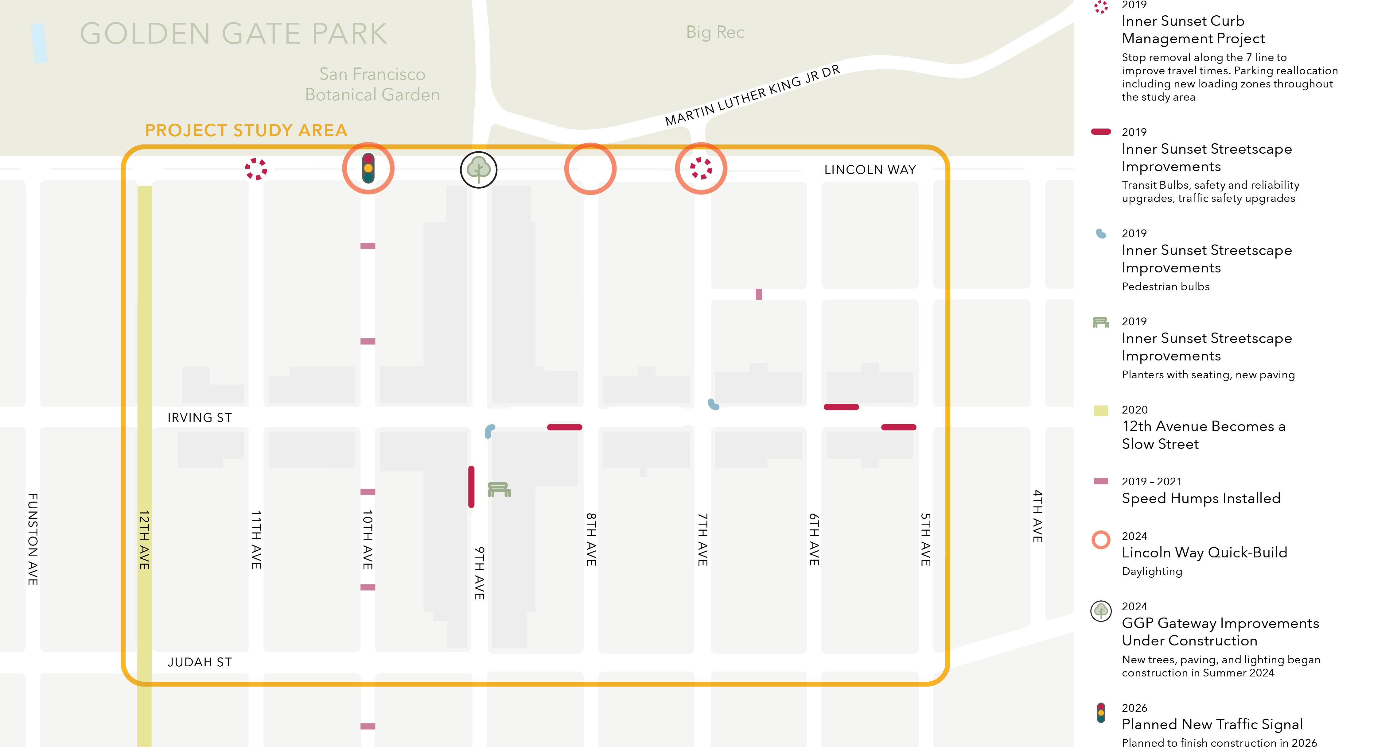
The Study Area and nearby streets have seen several changes in the last five years with a focus on improvements to prioritize people walking and biking rolling as well as transit safety and reliability. Below is a summary of the transportation projects that have been implemented in the study area in the past five years:
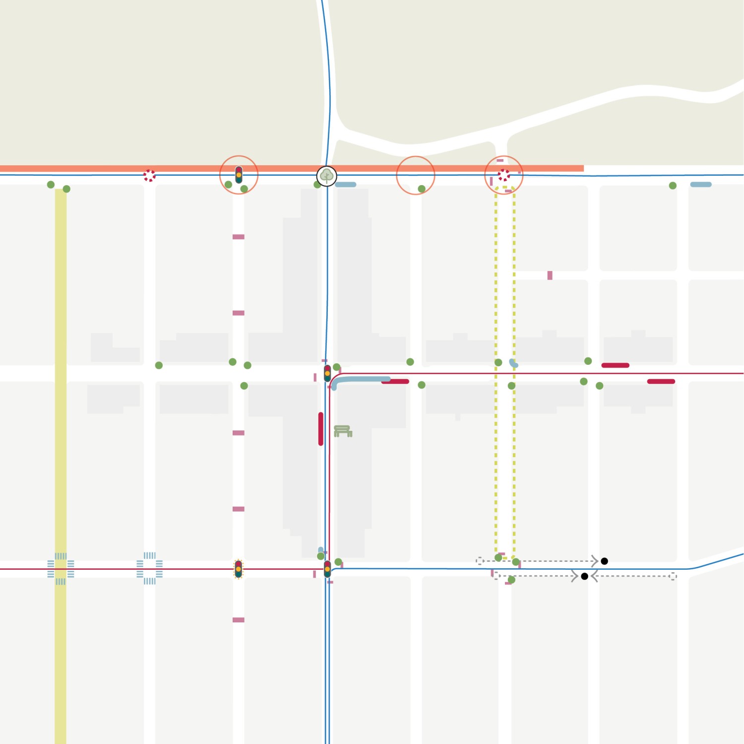
Figure 1-2 displays the locations of transportation projects that have been or are planned to be implemented in the study area.
Community outreach was a core element of the planning process and was conducted over two phases. The outreach plan was developed to reach a wide range of stakeholders in the Inner Sunset district, with particular emphasis on diverse ethnicities, ages, and backgrounds. Each phase of outreach included conversations with community members, one in-person Town Hall meeting, and an online survey. Materials were made available in English, Chinese, and Spanish. Raw materials, survey results, and graphics from the process can be found in the Appendices.
Below are the major stakeholder groups for the Study:
The first phase of outreach included initial conversations with community members; an online survey which included questions regarding the draft goals; and an in-person Town Hall meeting which included a presentation of the draft needs and goals. Phase 1 outreach activities focused on discussing the scope and purpose of the Study and listened to community experiences, needs, and concerns. Phase 1 outreach activities began in July 2024 and ended in October 2024. After those activities were concluded, the needs and goals were further refined to reflect community input.
The second phase of outreach presented draft concepts and recommendations to address the transportation challenges and needs identified through Phase 1. Phase 2 outreach activities began in September 2025 and ended in October 2025. The study team collected community feedback on the draft concepts through meetings with community groups, an in-person Town Hall meeting, pop-up events, and an online survey. Public feedback on the draft concepts informed refinements to the concepts.
A summary of outreach activities and findings from Phase 1 outreach is presented in Section 2.6. Summaries of outreach findings and activities from Phase 2 outreach are presented in Section 3.1 and Section 3.6, respectively.
The purpose of this section is to summarize observed and community-reported travel trends and assess transportation safety, circulation, and utilization within and adjacent to the study area. The data gathered to support this assessment includes community input, counts of people walking, bicycling, driving, and riding transit, parking and loading utilization, collision history, and transit data provided by the San Francisco County Transportation Authority (SFCTA) and San Francisco Municipal Transportation Agency (SFMTA), as well as site observations conducted by the study team during summer 2024. This data analysis informed draft goals for the Study and together the “needs and goals” were brought to the community for consideration in Phase 1 of outreach.
The Inner Sunset and adjacent land uses such as Golden Gate Park and UCSF Parnassus Heights are major destinations for visitors from all over the region and private vehicles are an important mode of transportation in the neighborhood. The study area is bounded to the north by Lincoln Way, which is a major east-west thoroughfare for people driving between the Sunset and Downtown San Francisco and regional destinations via the U.S. 101 terminus at Octavia Boulevard. Lincoln Way is characterized as a Park Edge Street in the City of San Francisco’s Better Streets Plan, which is intended to balance high volume of through traffic with a generous walking realm and recreational and ecological amenities. On the eastern side of the study area, 7th Avenue serves as an important route for north-south travel and is defined as a residential throughway in the Better Streets Plan, intended to handle higher volumes of traffic than the average residential street. Other roadways in the Inner Sunset are defined as neighborhood commercial or neighborhood residential streets in the Better Streets Plan and are thus intended to prioritize slower speeds and local access for people traveling by all modes.
Vehicle volumes along three representative neighborhood streets are provided in Table 2-1 based on StreetLight Data, a big data service, from fall 2021. Other roadways in the study area would typically have lower vehicle volumes than those presented in the table due to their locally serving nature. Most through traffic in the study area occurs on Lincoln Way, which is a major east-west arterial that carries roughly 28,700 daily vehicles on weekdays and 31,700 daily vehicles on weekends.Vehicle volume data is from StreetLight Data, a big data resource, which was calibrated against local traffic counts. The data was collected in 2021. Count data in the vicinity from 2023 indicates that overall traffic volumes have changed minimally since 2021 and that the StreetLight Data volumes are still a useful source of volumes. The remaining streets are local-serving and carry 4,000 – 10,000 vehicles per day, largely destined for local residences and businesses. Weekend vehicle volumes on 9th Avenue between Lincoln Way and Irving Street are substantially higher than weekday volumes due to park visitors, with 8,300 vehicles on the weekend compared to 5,800 vehicles on a typical weekday.
On weekends, 9th Avenue becomes a major access point for people driving into Golden Gate Park. Vehicle queues of park visitors waiting to enter the Music Concourse Parking Garage or looking for on-street parking in Golden Gate Park typically extend back on 9th Avenue across Lincoln Way into the Inner Sunset during the middle of the day. Observations in summer 2024 indicate that vehicle queues on northbound 9th Avenue typically extend the entire block between Lincoln Way and Irving Street. Vehicles also back up from the intersection of 9th Avenue and MLK Drive on westbound MLK Drive and Lincoln Way.
Most intersections in the study area are either signalized or all-way-stop-controlled. The exceptions include side-street stop controlled local street approaches on thoroughfares such as Lincoln Way (12th, 11th, 10th, 8th, and 6th avenues), Judah Street (11th and 8th avenues), and Irving Street (8th Avenue). Side-street-stop controlled intersections have the potential to create hazardous conditions for people driving when unprotected left-turns are allowed or adequate sight distance is not provided for people driving on the side-street approach. An example is the intersection of Irving Street and 8th Avenue, which has poor visibility for people driving on 8th Avenue of people traveling on Irving Street due to parked cars adjacent to the intersection. This and other locations in the study area are not yet in compliance with Assembly Bill 413 and Section 22500 of the California Vehicle Code, which requires a 20-foot gap between parked cars and a crosswalk or a 15-foot gap where there is a curb extension. SFMTA recently daylit intersections on Lincoln Way as a part of the Lincoln Way Quick-Build Project.
As both a residential and commercial area, the Inner Sunset has high demand for parking and loading space. Metered parking can be found along Irving Street between 7th Avenue and 12th Avenue, along 9th Avenue between Judah Street and Lincoln Way, and along Judah Street between 8th Avenue and 9th Avenue, as well as on 7th Avenue, 8th Avenue, and 10th Avenue near the intersection with Irving Street. Residential permit parking (Zone J) covers much of the unmetered study area, including most of 5th, 6th, 7th, 8th, and 11th Avenues, as well as Lincoln Way east of 8th Avenue and Judah Street east of 10th Avenue. Commercial and passenger loading zones are found throughout the study area, primarily on Irving Street and 9th Avenue. Their locations were most recently assessed as part of the 2019 Inner Sunset Curb Management Project, which resulted in a net reduction of nine full-time parking spaces and a net increase of 13 loading spaces within the project study area bounded by Lincoln Way, Judah St, 12th Avenue and 5th Avenue. The Inner Sunset Curb Management Project also recommended and implemented a stop consolidation for the 7 Haight/Noriega on Lincoln Way. By removing the stops at 7th and 11th Avenues, there is a projected time savings for the bus and 10 additional parking spaces were added where the transit stops were located.
Passenger and commercial loading are also common on the commercial blocks of Irving Street and 9th Avenue, especially in the evening. Observations in summer 2024 indicate that delivery vehicles will at times double-park along 9th Avenue and Irving Street and may at times block the N Judah light rail line. SFMTA recently installed quick-build posts on the southeast corner of 9th and Irving to prevent loading activity from blocking the eastbound N Judah at this location. Loading activity was also observed at bus stops along 9th Avenue, partially blocking the bus stop and sometimes forcing the bus to partially block a crosswalk or not pull fully to the curb.
The SFMTA has also begun implementing new Public Right-of-Way Accessibility Guidelines for accessible parking (blue zones) citywide, including in the Inner Sunset. The agency is adding blue zones as part of all new street projects and as new parking meters are added, with the goal of achieving 4% blue zones in total metered parking spots. The number of active blue zones in the city as of 2025 is 832.
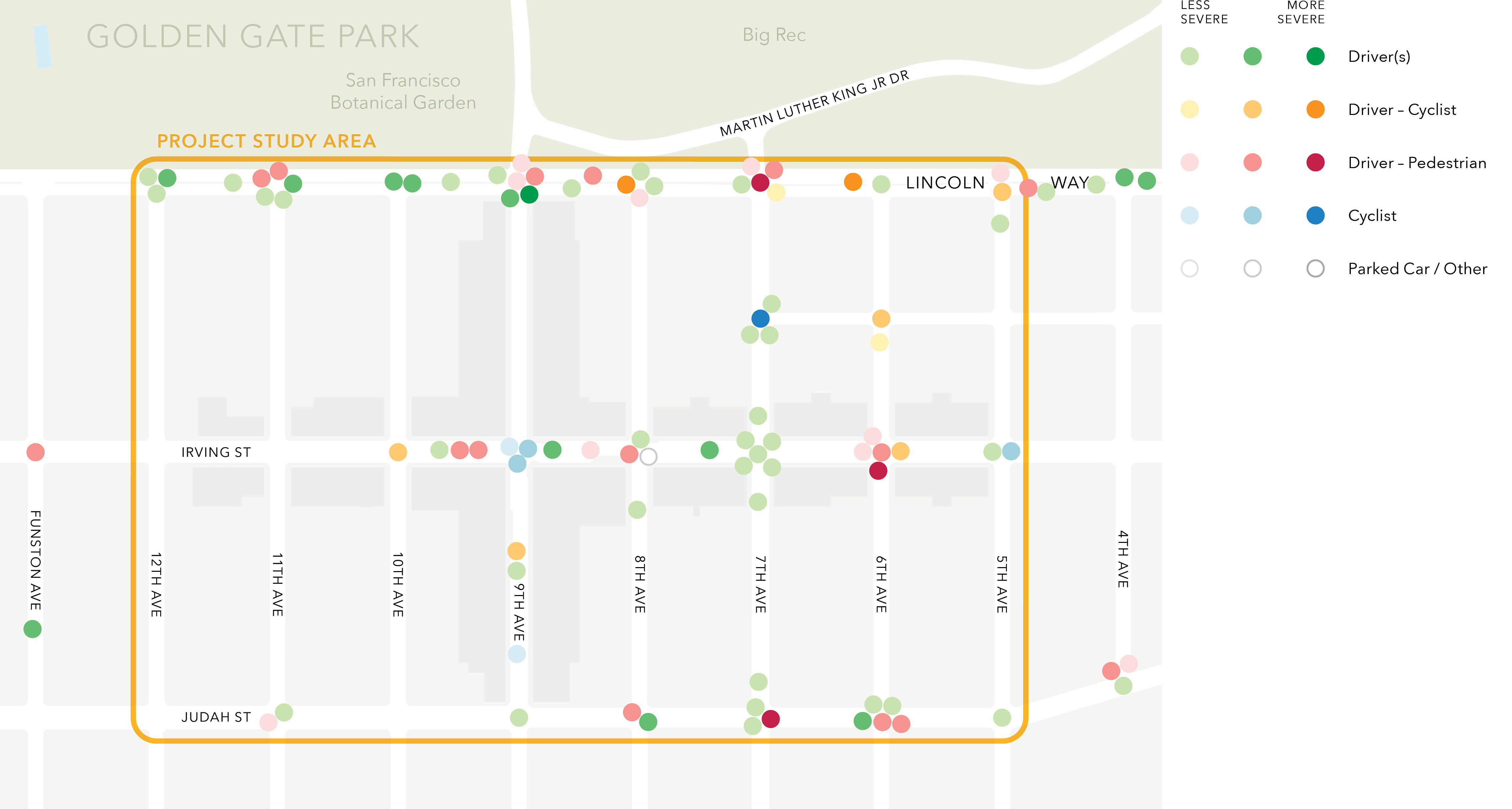
The study team analyzed crash data from Transbase, a database of collisions resulting in injury or fatality reported to San Francisco Police Department and maintained by San Francisco Department of Public Health. There were 88 crashes from June 2019 through May 2024 recorded within the study area with a 100-foot buffer along the edges. Crashes were concentrated on Lincoln Way, Irving Street, and Judah Street. Part of the High Injury Network — which is the 12% of city streets where 68% of severe and fatal traffic crashes occur — falls within the study area on Lincoln Way from 5th to 10th Avenues. The majority of crashes (53%) involved only drivers and 28% involved people walking and driving. Of the 25 crashes involving drivers and people walking, just under half of them (11) were due to a driver failing to yield to a person crossing at a crosswalk. There were 15 crashes involving cyclists, which were concentrated on Irving Street, 6th Avenue, 9th Avenue, and Lincoln Way. Over half (68%) of crashes happened during daylight and 39% occurred between 2:00 p.m. and 6:00 p.m. The most common type of crash (87%) was a broadside collision, also known as a T-bone.
Of the 88 total crashes, none was fatal and seven were severe (8%). Lincoln Way was the most common street for severe crashes, with three out of the seven. Three of the severe crashes involved people walking, two of which were the result of the driver failing to yield at a crosswalk. Another three of the severe crashes involved people biking; in all three, the cyclist was at fault for reasons such as traveling in the wrong direction.Details of the March 6, 2026 crash involving a cyclist are still under investigation at the time of writing of this report. Data in this section covers June 2019 through May 2024 only.
Figure 2-1 shows the type, severity, and location of crashes in the study area. Each dot represents one crash. Less severe crashes involved complaint of pain, the next level of severity involved visible injury and more severe crashes involved broken bones and lacerations. Figure 2-2 displays the frequency of different crash types over a 5-year period from 2019 through 2023.
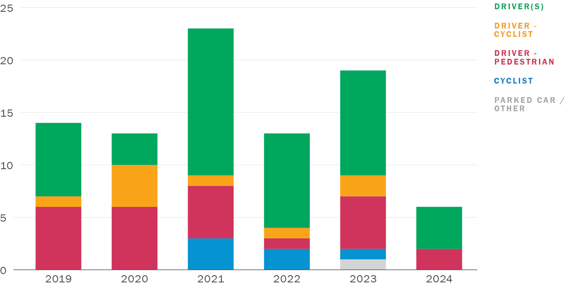
Source: Transbase, 2024. Note that 2024 data only include crashes recorded from January to June.
Download chart data (CSV)
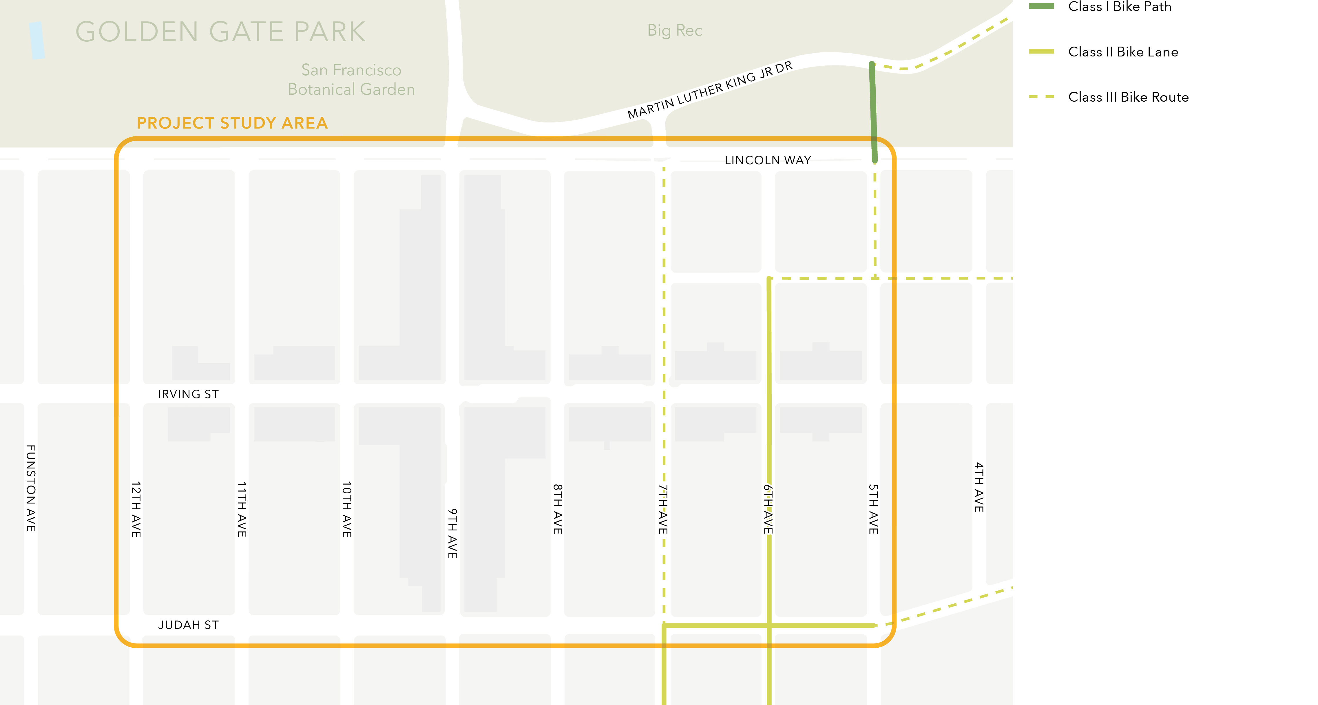
While bicycling is a common mode of transportation in the Inner Sunset,According to 2019 intercept and resident surveys for the Inner Sunset Curb Management Project bicycling infrastructure that is comfortable for all ages and abilities is limited within the study area, as shown in Figure 2-3. Counts taken in 2021 showed roughly 100 people bicycling passing through the 9th Ave/Lincoln Way intersection during the AM peak hour and roughly 70 people bicycling during the PM peak hour.Golden Gate Park Traffic Study Presentation, February 2022 Yet, the only designated bicycle routes are unprotected and these include bike lanes on 6th Avenue, 7th Avenue (south of Judah Street), and two blocks of Judah Street, as well as bike routes where people bicycling share the road with cars on portions of 7th Avenue (north of Judah Street), Hugo Street, and 5th Avenue.
The connection for cyclists is particularly under-developed for those accessing Golden Gate Park from the Laguna Honda Boulevard/7th Ave corridor. While 5th Avenue, 6th Avenue, and Hugo Street have low traffic volumes and speeds, 7th Street is a major vehicle thoroughfare that creates an uncomfortable environment for many people bicycling due to the lack of protection from high vehicle volumes and speeds of adjacent traffic.
Further, while 5th and 7th Avenues have designated bicycle facilities into Golden Gate Park, many people bicycling use the 9th Avenue entrance as it provides the only connection to the park for people bicycling between 7th Avenue and 19th Avenue, the longest stretch of Golden Gate Park without bicycle access, due to the location of the San Francisco Botanical Garden.
Crossing the intersection of Lincoln Way and 9th Avenue on a bicycle is uncomfortable for many people due to the high traffic and walking volumes and lack of designated bicycle infrastructure within the Inner Sunset or Golden Gate Park.
Irving Street is another popular bicycle route, as it is the flattest and more centrally located east-west route through the Inner Sunset. The nearest east-west bicycle facility outside of the study area is Kirkham Street, which has bike lanes but is located up a substantial hill from the study area. Neither 9th Avenue nor Irving Street feature any bicycle facilities and people bicycling must navigate private vehicles parking, loading, or occasionally double-parking and blocking the streets. In addition, on the blocks of 9th Avenue, Irving Street, and Judah Street where the N Judah runs, people bicycling must be careful around the light rail tracks, which can be a potential hazard. Observations in summer 2024 indicate that some people opt to ride on the sidewalk to avoid these conflicts on 9th Avenue, 10th Avenue, Irving Street, and Lincoln Way, bringing them into conflict with people walking in this busy area.
The Inner Sunset is a very walkable neighborhood that is a popular destination for dining, shopping, and services, as well as a key access point to Golden Gate Park. “Walking” road users also includes the “rolling” road users such as people using wheelchairs or other personal mobility devices. The neighborhood features complete sidewalk infrastructure along most blocks that meet the Better Streets Plan standards. An exception is the north side of Lincoln Way, which has no sidewalk west of 11th Avenue nor east of 7th Avenue, despite the provision of parking spaces, which forces people to walk in the street or the dirt to access their vehicles. This lack of a sidewalk also limits the ability to add blue zones for disabled parking along the perimeter of the park.
All intersections in the neighborhood have amenities to raise the visibility of people crossing the street, such as curb ramps, high-visibility crosswalks, and countdown timers at signals. At uncontrolled crossings at side-street stop-controlled intersections, features such as rapid rectangular flashing beacons (Irving Street at 8th Avenue), median islands (Judah Street at 8th Avenue), or yield to pedestrian signs with sharks’ teeth pavement markings (Lincoln Way at 11th Avenue) are provided. Intersections that are not yet in compliance with daylighting laws (Assembly Bill 413 and Section 22500 of the California Vehicle Code) may have reduced visibility between people driving and crossing the street as noted in the vehicle circulation section.
Observations indicate that the highest levels of people walking are on 9th Avenue and the commercial blocks of Irving Street. Walking activity is typically higher on weekends than weekdays, especially sunny weekends when Golden Gate Park is a popular destination. Very high levels of people cross Lincoln Way at 9th Avenue throughout the day on weekends.
The entire study area is within a five-minute walk of high-quality transit service with at least a 10-minute frequency. Transit routes serving the area are the 6 Hayes/Parnassus, 7 Haight/Noriega, 43 Masonic, 44 O’Shaughnessy, and N Judah. The 6, 7, 43 and 44 Muni lines serve as key connectors of focus neighborhoods designated in the Muni Service Equity Strategy, which focuses on improving Muni performance in San Francisco neighborhoods with high percentages of households with low incomes and people of color.
Another option for residents and visitors to the Inner Sunset includes paratransit, which SFMTA operates. Through the SF Access van service, SF Paratransit taxi and Group Van services, the most frequent origin and destination in the Inner Sunset is the UCSF Parnassus campus, just outside of the study area, which provides medical services. In 2023, over 2,500 trips included the Parnassus campus as the origin or destination.
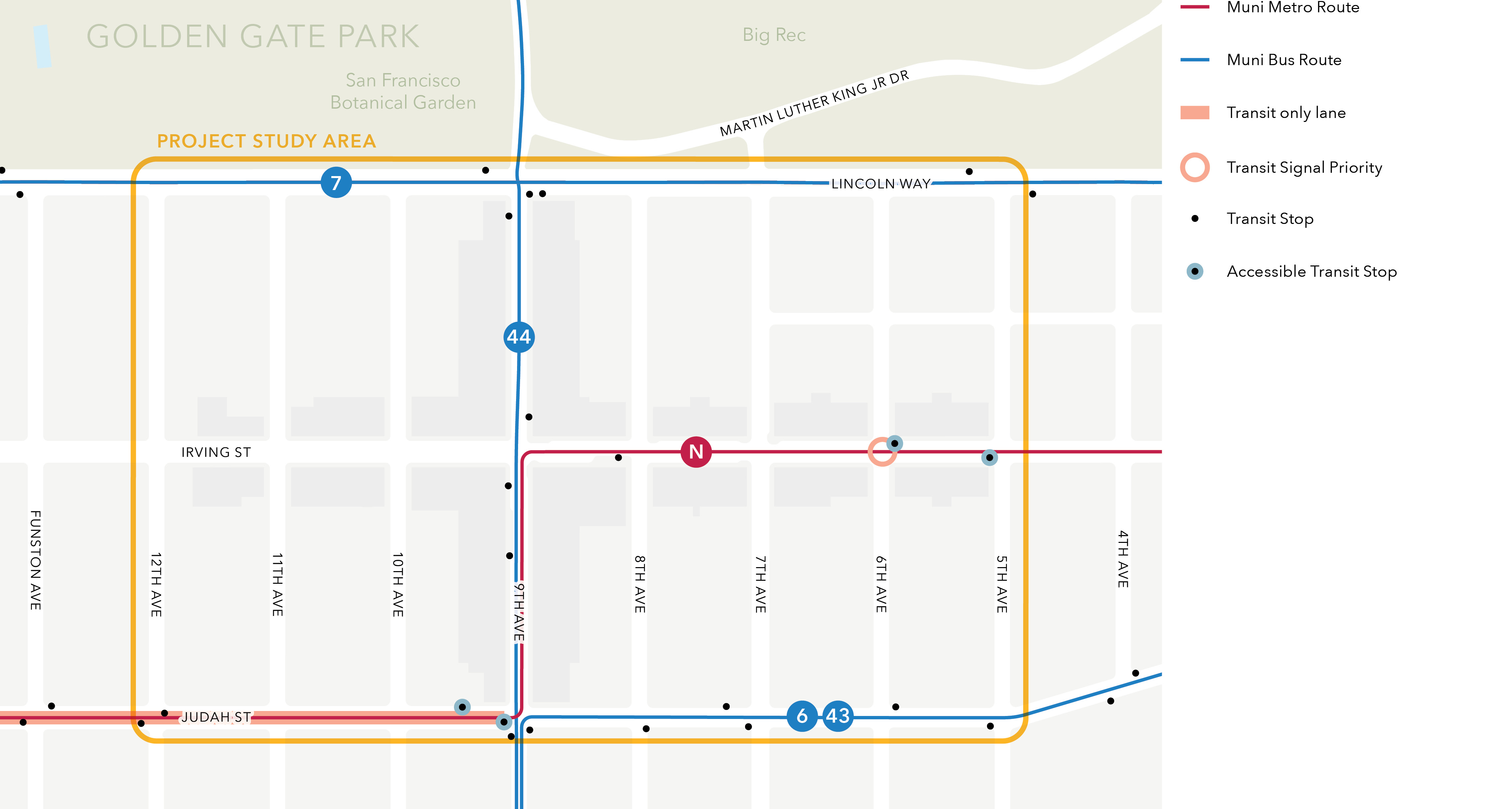
Figure 2-4 shows these routes and key transit facilities and existing improvements within and around the study area and Table 2-2 presents the frequencies for these routes by time of day.
To determine key transit usage patterns, the study team reviewed a sample of ridership data looking at January and February boardings and exits from 2020 to 2024. The following sections summarize findings from this analysis.Full data analysis can be found in the Inner Sunset Transportation Study Transit Ridership Analysis Memorandum.
The 6 Hayes/Parnassus bus runs on Judah Street along the southern edge of the study area from the east before turning south onto 9th Avenue. 6 Hayes/Parnassus connects the study area to downtown and the Haight Street corridor to the east and Golden Gate Heights to the south. The 6 Hayes/Parnassus has late night service (7 p.m. – 1 a.m.), but no overnight Owl service (1 a.m. – 5 a.m.). The 9th and Judah stop westbound to Golden Gate Heights on Saturdays is in the top 15% of boardings for the route.
The 7 Haight/Noriega bus runs on Lincoln Way along the northern boundary of the study area, connecting the study area to downtown and the Haight Street corridor to the east and the Outer Sunset and Ocean Beach to the west. As of February 2026, the 7 Haight/Noriega is in service from 5 a.m. to midnight daily but has no overnight Owl service. From 5th to Funston, exits have exceeded pre-pandemic ridership heading westbound toward Ocean Beach. Overall, the line has recovered pre-pandemic ridership by 103% on weekends and 100% on weekdays. The Lincoln Way and 9th Avenue stop going outbound on Saturdays is in the top 15% of exits along the entire route, indicating high ridership from the east.
The 43 Masonic bus runs on Judah Street along the southern boundary of the study area, connecting the study area to the Marina district and the Presidio to the north and Sunnyside and Balboa Park to the south. The 43 Masonic has late night service, but no overnight Owl service. The 9th and Judah stop is in the top 15% of boardings and exits for the entire route in both directions on weekdays and Saturdays.
The 44 O’Shaughnessy bus runs on 9th Avenue through the center of the study area, connecting the study area to Golden Gate Park and the Inner Richmond to the north and Glen Park and the Bayview to the southeast. The 44 O’Shaughnessy provides the most direct transit access to destinations within Golden Gate Park from neighborhoods to the south and east such as Glen Park, Portola, and Bayview and thus serves as a critical link for visitors from these equity priority neighborhoods. The 44 O’Shaughnessy has late night service along its full route and overnight Owl service along a portion of its route, but not the portion that serves the study area. The 9th and Lincoln stop coming from the Inner Richmond southbound to the Bayview is in the top 15% of riders getting off the 44 O’Shaughnessy on Saturdays.
The N Judah light rail runs on Irving Street, 9th Avenue, and Judah Street, through the center of the study area, connecting the study area to downtown to the east and the Outer Sunset and Ocean Beach to the west. The N Judah travels in the transit-only lanes on Judah Street west of 9th Avenue, which are the only protected transit lanes in the study area. The N Judah has service at all hours, though it is replaced by a bus service overnight. Most riders of the N Judah are traveling from the direction of downtown San Francisco and the level of ridership is very similar on weekdays and weekends. On Saturdays, the 9th Avenue and Irving Street stop has the second-highest number of westbound exits of the entire route and the Irving Street and 8th Avenue stop has the highest number of boardings going eastbound; this indicates heavy ridership between the Inner Sunset and the east side of San Francisco, especially on the weekends.
The transit travel time analysis identifies segments of delay and areas where potential disruptions occur that compromise transit reliability. The analysis used sample data from January and February 2024, looking at both the weekday PM peak and weekend midday time periods. The analysis looks at the median segment speed, as well as the 90th percentile speed, which represents the most congested points within the peak periods. The difference between the 90th percentile and median speeds is considered a measure of the variability of speed along a segment; higher variability in speed even on a small segment can contribute to decreased reliability of a transit route along its entire length.
The 6 Hayes/Parnassus bus has two segments in the study area for both the eastbound and the westbound direction. The travel time across the entire study area is 2 to 3 minutes in both directions during weekdays and weekends.
Median average speeds are similar across segments in both directions during weekdays and weekends (around 5 – 6 MPH). Variability in speeds is slightly higher on the segment between the 9th/Judah and Judah/7th stops in both directions, which could suggest more frequent or severe traffic disruptions at the 9th and Judah intersection. Overall, weekend speeds are slightly higher across most segments than weekday speeds, indicating lighter traffic along Judah Street during the weekends. Closely spaced stops on Judah Street may contribute to excess travel time on this corridor. Existing stops between 5th Avenue and 9th Avenue are spaced between 325 to 650 feet apart, below the SFMTA’s recommended stop spacing of 800 to 1360 feet. Some stops are also located in less optimal locations, such as the near side of a signal.
The 7 Haight/Noriega bus has two segments in the study area for both the eastbound and the westbound direction. The travel time across the entire study area is 2 to 5 minutes in both directions during weekdays and weekends.
Median average speeds are notably lower on the segment between the Lincoln/9th and Lincoln/5th stops than adjacent segments in both directions on weekdays and weekends. Weekend average speeds are higher than weekday figures for most segments. The westbound direction between 5th and 9th Avenue has the highest variability in speeds on weekdays and lower average speeds on the weekends, both indicating potential traffic disruptions and greater activity around the two park entrances at 7th Avenue and at 9th Avenue.
The 43 Masonic bus shares the same stops and segments as the 6 Hayes/Parnassus bus in the study area for both the northbound and the southbound direction. The travel time across the entire study area is 1 to 3 minutes in both directions during weekdays and weekends.
Median average speeds are generally lower on the segment between the 9th/Judah and Judah/7th stops than on adjacent segments in both directions, though not by much. The variability in speeds is slightly higher on the same segment in both directions on weekends, which could suggest more frequent or severe traffic disruptions at the 9th and Judah intersection. Closely spaced stops on Judah Street may contribute to excess travel time on this corridor. Existing stops between 5th Avenue and 9th Avenue are spaced between 325 to 650 feet, below the SFMTA’s recommended stop spacing of 800 to 1360 feet. Some stops are also located in less optimal locations, such as the near side of a signal.
The 44 O’Shaughnessy bus has three segments in the study area for both the northbound and the southbound direction. The travel time across the entire study area is 4 to 8 minutes in both directions during weekdays, and 4 to 13 minutes in both directions on weekends, indicative of the high variability in travel time through the study area due to weekend congestion.
Median average speeds are lowest on the segment between the 9th/Irving and 9th/Lincoln stops in the southbound direction on weekdays and both directions on weekends; this segment also has the highest variability in speeds in the northbound direction on weekdays. There may be greater activity and potential traffic disruptions within that segment. On the weekends, the northbound segment between the 9th/Lincoln and Academy of Sciences stops experiences the highest variability in speeds, which suggests higher rates of traffic and activity into Golden Gate Park that may disrupt the route’s travel time.
The N Judah light rail has three segments in the study area for both the eastbound and the westbound direction. The travel time across the entire study area is 4 to 6 minutes in both directions during weekdays, and 5 to 7 minutes in both directions on the weekends.
Across all days of the week, median travel times are lowest on the eastbound segment between the Judah/9th and Irving/8th stops, as well as on the westbound segment between the 9th/Irving and Judah/9th stops, which may be impacted by greater traffic and commercial activity around 9th Avenue and the intersections at Judah Street and Irving Street. Variability in speeds is quite similar across all segments on both weekdays and weekends.
The study team developed goals based on adopted plans and policies and observed and reported challenges around the existing conditions of the study area. These goals guide the development and evaluation of recommendations for the study area.
The study team reviewed existing plans and policies related to transportation and land use at a citywide level as well as those specific to the study area. The plans and policies considered include:
The Study is guided by the goals of ConnectSF, San Francisco’s integrated plan for long-range transportation needs. ConnectSF has five goals that structure the City’s approach to transportation planning and investment.
Of these five goals, two are considered central to this Study:
The remaining three goals are considered to be higher-level guiding principles for this Study:
Table 2-13 summarizes the goals of the Study. Each goal statement is accompanied by one or more ConnectSF goals, as well as identified challenges which justify the goal and desired outcomes. Each goal and related objective are discussed in more detail below. Each goal and related objective are discussed in more detail below.
Objective: Improve safety for vulnerable road users, transit riders, and motorists traveling within and through the study area. Improving roadway safety and perceived safety for vulnerable road users is a key part of increasing the viability of active transportation options and enhancing accessibility, economic vitality, and health. Lincoln Way, a major east-west corridor through the study area, was identified to be on the city’s High Injury Network. Intersections along Lincoln Way, particularly at 9th Avenue, observed several severe crashes in recent years involving drivers, pedestrians, and cyclists. Prioritizing safety is consistent with the citywide Vision Zero commitment to Safe Streets. Proposed concepts leverage proven safety countermeasures and the tools specifically identified in SFMTA’s Vision Zero Action Strategy to align the recommendations with best practices for reducing or eliminating risk factors associated with severe collisions.
Objective: Implement improvements to streamline transit service. Many transit routes serve the study area. Challenges like double-parking and long vehicle queues often resulted in delays and reduced reliability for these routes (especially the 44 bus). Proposed concepts strive to minimize delay and improve travel time for transit service that passes through the study area. Concepts explore different ways to balance the needs of vehicular traffic and transit service, as well as the needs of through traffic with local access. Concepts seek to avoid adding unmanageable vehicle delays or queuing for drivers, especially when such effects could impact local quality of life, access to residences and businesses, or divert drivers through other communities.
Objective: Provide a convenient and comfortable environment to reach key destinations for people who live within and near the study area, with a focus on walking, biking, and transit. The study area includes limited and high-stress bicycle options for connecting to local destinations such as Golden Gate Park, businesses, and schools. Drivers who wished to access the park on weekends experienced significant delays and long queues, mostly due to vehicles awaiting access to the Music Concourse Parking garage or searching for on-street parking. San Francisco’s Transit First policy establishes that travel by public transit, by bicycle and on foot should be an attractive alternative to travel by private automobile. The concepts also consider how access to transit stops may be improved to better serve people walking and biking. Mode-share goals established in San Francisco’s Climate Action Plan reinforce this policy with an emphasis on connectivity. Connectivity considers several different facets: ability to access goods, services, greenspaces, and local/regional transit connections; reducing the impact of barriers created by major roads; and constructing low-stress multimodal networks. The Study developed recommendations which improve conditions for people walking and biking to increase the comfort of connections within and through the study area.
Objective: Work with merchants and community members to improve access to goods and deliveries. Private and commercial vehicles were often double-parked in the study area which resulted in vehicle and transit delays. The Study worked with merchants and community members to ensure the neighborhood’s many amenities and businesses are accessible and offer design solutions to make them easier and safer to reach, especially by walking, biking, and transit. This also includes circulation improvements for deliveries.
Phase 1 of community outreach identified a list of transportation challenges and project priorities with substantial input from the community. Phase I activities were conducted to confirm that documented existing conditions, needs, and goals identified by the study team were correct and offer the community an opportunity to identify additional challenges.
An in-person Town Hall meeting was held at the San Francisco County Fair Building where community members were invited to share feedback on documented needs and goals and existing conditions, as well as to identify additional transportation challenges within the study area. The presentation included an overview of the study area, draft needs and goals, and conclusions from documented existing conditions. Feedback was gathered through group discussions, comment cards, and interactive wall posters. Comments were grouped into broad themes then further separated into specific subthemes. Comments were also categorized by sentiments, with a label of High, Medium, or Low assigned to each sentiment to reflect the relative frequency with which it was mentioned.
Community members had the opportunity to interact with the project through an online survey on the project’s website. Throughout September 2024, the survey was open to the public for comments on travel preferences within and around the study area, mode choice, perceived safety, and confirmation and prioritization of drafted goals.
A scavenger hunt was conducted to introduce community members to recent and planned transportation changes in the neighborhood. Five different transportation measures were selected to be identified in the scavenger hunt:
Participants were also asked to share their favorite spot in the neighborhood.
Responses were collected from both the in-person community meeting and the online survey. About 125 people attended the in-person event and 1,826 respondents filled out the survey.
There was general support for the four drafted goals (as described in the Needs and Goals section). 60% of all respondents strongly agreed or agreed with the draft goals. 35% thought that Goal 1, which focused on safety for vulnerable road users, should be prioritized, and 19% wanted Goal 2, which aimed to improve transit reliability, to be prioritized.
Respondents who indicated disagreement suggested other areas of focus. The more frequent suggestions highlighted prioritization of vehicles, more parking, and traffic enforcement. Less frequent suggestions included Muni improvements and street lighting.
More than half of respondents agreed that the documented crashes in the study area reflect where community members have safety concerns. Many daily drivers reported that they never felt unsafe when traveling through the Inner Sunset. Those who never drove rarely shared that same sentiment. More than a third of respondents experienced safety issues because of double-parking in the area.
Community members repeatedly brought up unsafe conditions for walking and rolling along Lincoln Way, Irving Street, and 9th Avenue, as well as crossing Lincoln Way into the park. A popular sentiment was that interactions with vehicles were uncomfortable, especially with fast-speeding vehicles. Drivers were reported to be driving too fast on 7th Avenue, Judah Street, and Lincoln Way.
Community members identified Lincoln Way, Irving Street, and 9th Avenue as priority streets for safety improvements. They also identified intersections along Lincoln Way and Irving Street, particularly at 5th Avenue, 8th Avenue, and 9th Avenue, as priority intersections for safety improvements.
Residents wanted to see improved car access so that vehicles can travel through the area more easily. Many respondents identified traffic delays along 9th Avenue, partly due to double-parking and people circling for parking to access nearby destinations such as the Music Concourse and UCSF Parnassus. A frequent suggestion was to keep traffic lanes open throughout the neighborhood.
Out of those who responded, people generally preferred not to have only parking or only loading. Residents in the area expressed even less of a desire to have only parking or only loading. Many people did want more parking along Irving Street, 7th Avenue, and 9th Avenue, as well as more loading zones overall. Some also shared concerns about too much free or underpriced parking in the area.
A third of respondents use transit at least a couple times a week, if not daily, to travel to, from, and within the Inner Sunset. Many respondents wanted to see greater transit priority and increased frequency for the N Judah and the 44 O’Shaughnessy.
Half of respondents never rode a bicycle or scooter to travel to, from, and within the Inner Sunset. Only 6% felt safe riding in the neighborhood. 29% indicated that a major barrier to rolling was being forced to ride with traffic. More than half of respondents felt safe walking in the neighborhood.
Residents wanted to see improved walking infrastructure such as improved visibility at crosswalks, signage, and wider sidewalks. There was an expressed need for more pedestrianized zones, with many members of the public who wanted to keep sidewalks clear and have more street lighting installed along 9th Avenue and Lincoln Way. There was also a desire to have safe options for people using bikes and scooters, yet there were some who did not want bike lanes in the neighborhood.
The study team developed project concepts in response to transportation challenges identified by the study team, stakeholders, and the community. The study team selected from a toolbox of potential design solutions that have been implemented elsewhere in San Francisco and shown success at appropriately addressing the identified challenges. The study team then evaluated these concepts based on how well they aligned with the goals of the Study. Concept development was a collaborative and iterative effort between the SFCTA, the SFMTA, and the consultant team.
Phase 2 of community outreach asked for feedback from stakeholders and community members on the project concepts presented in the near-, mid-, and long-term buckets introduced below. Input from the community informed refinement and advancement of the concepts, with modifications made to reflect this input discussed in Section 4.1. Overall, nearly 60 percent of respondents demonstrated support for all project concepts, with some concepts receiving support from nearly 85 percent of respondents. Each project concept description includes more details on the level of support and suggested changes each concept received from the community.
Final concepts are recommendations that align with citywide policies, are deemed technically feasible, and maximize projected benefits for the community.
The following concepts are categorized by level of complexity and concept readiness as near-, mid-, and long-term improvements. The timeframes included in this chapter represent the project team’s best assessment of time to implementation, though work to identify funding, plan, design, and conduct additional community outreach (as appropriate) could advance more quickly.
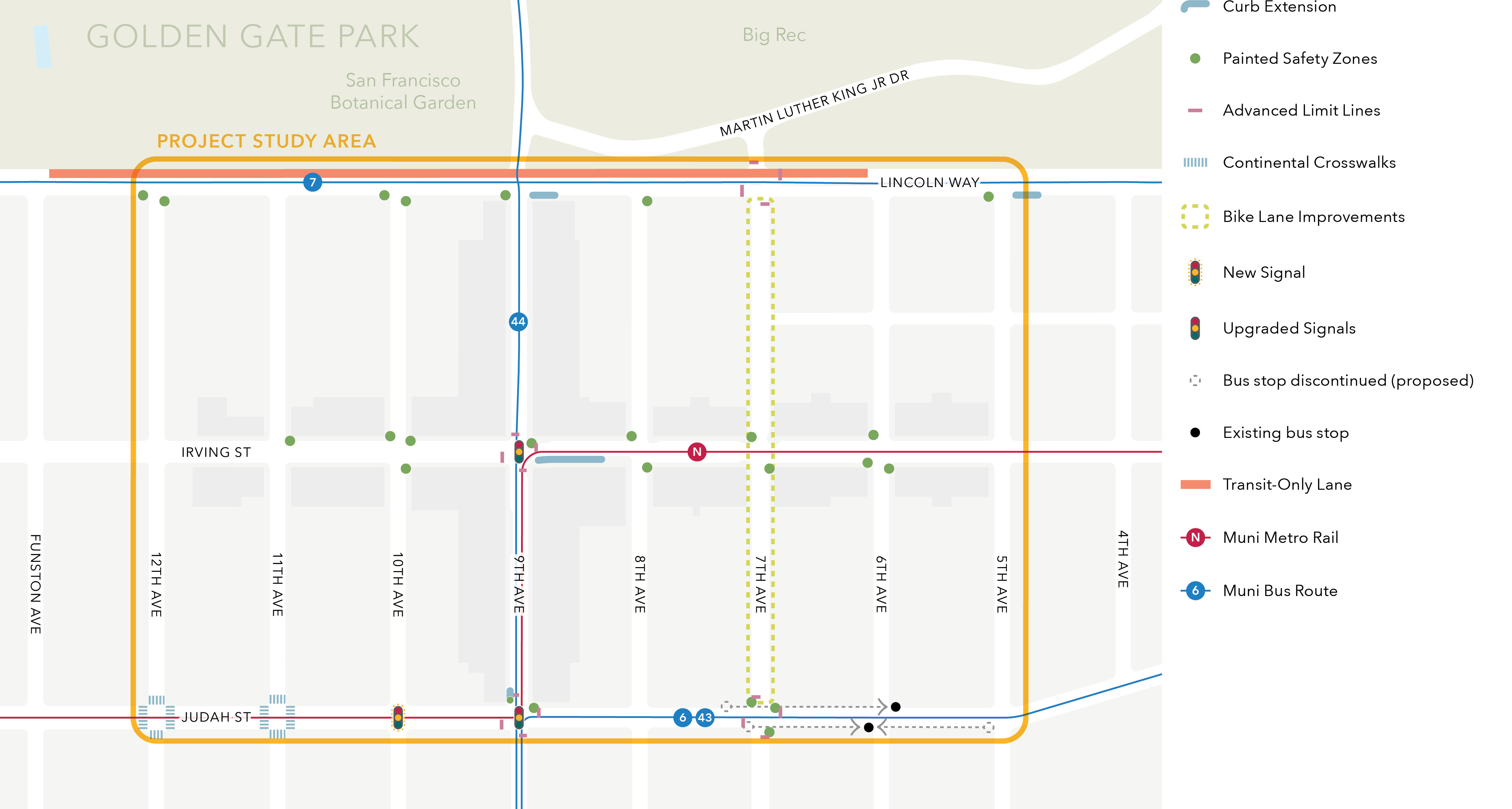
Figure 3-1 shows a map of all project concepts.
Relatively simple improvements that can be designed and implemented within one to two years.
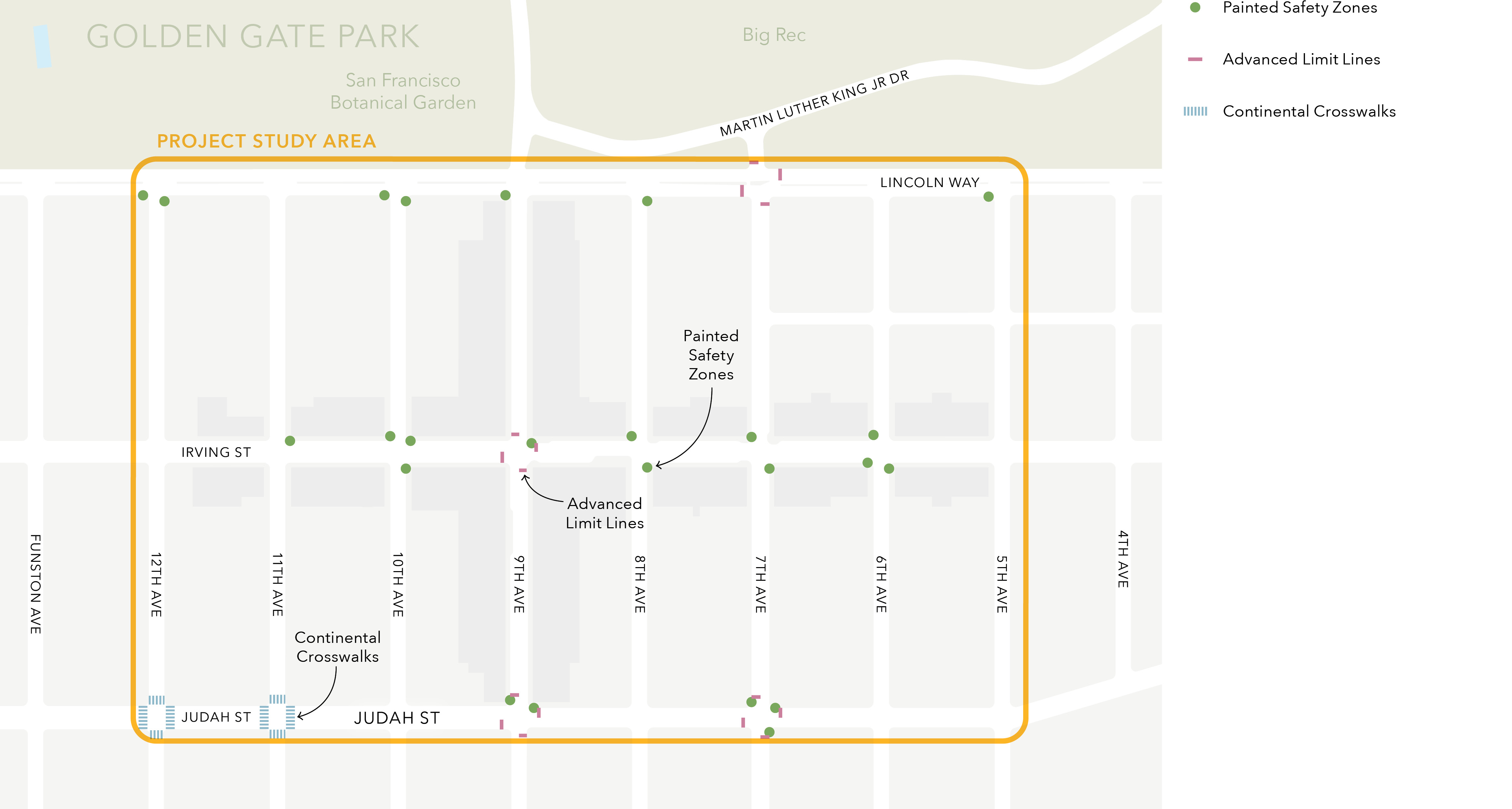
Implement pedestrian safety improvements across the study area. There are three different types of improvements that can be implemented to increase visibility for people crossing the intersection:
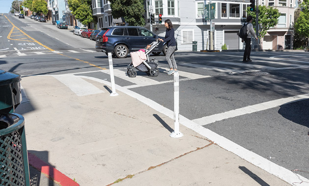
Painted Safety Zones
Painted road areas along the curb at intersection approaches that wrap around sidewalk corners. These zones make pedestrians crossing intersections more visible to people driving and reinforce state-mandated “daylighting,” or no-parking zones approaching intersections.
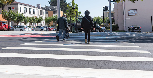
Continental Crosswalks
Higher-visibility spaces for people crossing the street. These designs, which consist of wide white stripes running parallel to the curb, have been shown to increase compliance with yielding to pedestrians in the crosswalk.
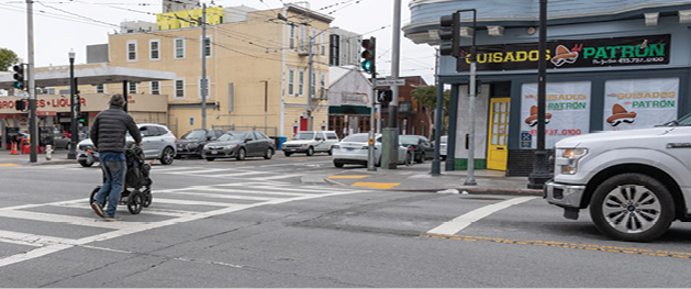
Advanced Limit Lines
Solid white lines that indicate where vehicles should stop for a stop sign or red light. These lines increase visibility and level of comfort by creating space between stopped vehicles and pedestrians.
This improvement received support from nearly 85 percent of respondents during outreach, the highest of all proposed improvements. Some respondents proposed additional locations for intervention, including at the intersection of 6th Avenue and Judah Street.
Figure 3-2 shows a map of potential locations and types of pedestrian safety improvements within the study area. Final locations for implementation will depend on a feasibility assessment as part of the detailed engineering process.
Suggest updates to mapping companies’ directions (e.g. Google, Apple, etc.) to improve traffic circulation and reduce congestion. Recommendations for community-driven, improved directions would be sent to mapping apps (e.g. Google Maps, Apple Maps, Waze, etc.) so they could route people in the most effective way. The re-routing would not impact existing streets or sidewalks.
Accessing the DeYoung Museum, Music Concourse Garage, and nearby sites can cause traffic backups partly because some vehicles on the north side of the park are routed to drive around the park and enter near 9th Avenue and Lincoln Way. Updated directions would suggest that drivers coming from the north side of the park enter the park southbound on 10th Avenue at Fulton Street.
Westbound vehicles turning left from Lincoln Way onto 8th Avenue can cause traffic jams. Updated directions would suggest that drivers on Lincoln Way turn left at intersections with traffic lights to improve traffic flow.
This improvement received support from 75 percent of respondents during outreach. In addition to the proposed improvements, respondents suggested alternative fixes such as routing vehicles onto Lincoln Way instead of through the park and prohibiting left turns onto 12th Street as it is a designated Slow Street.
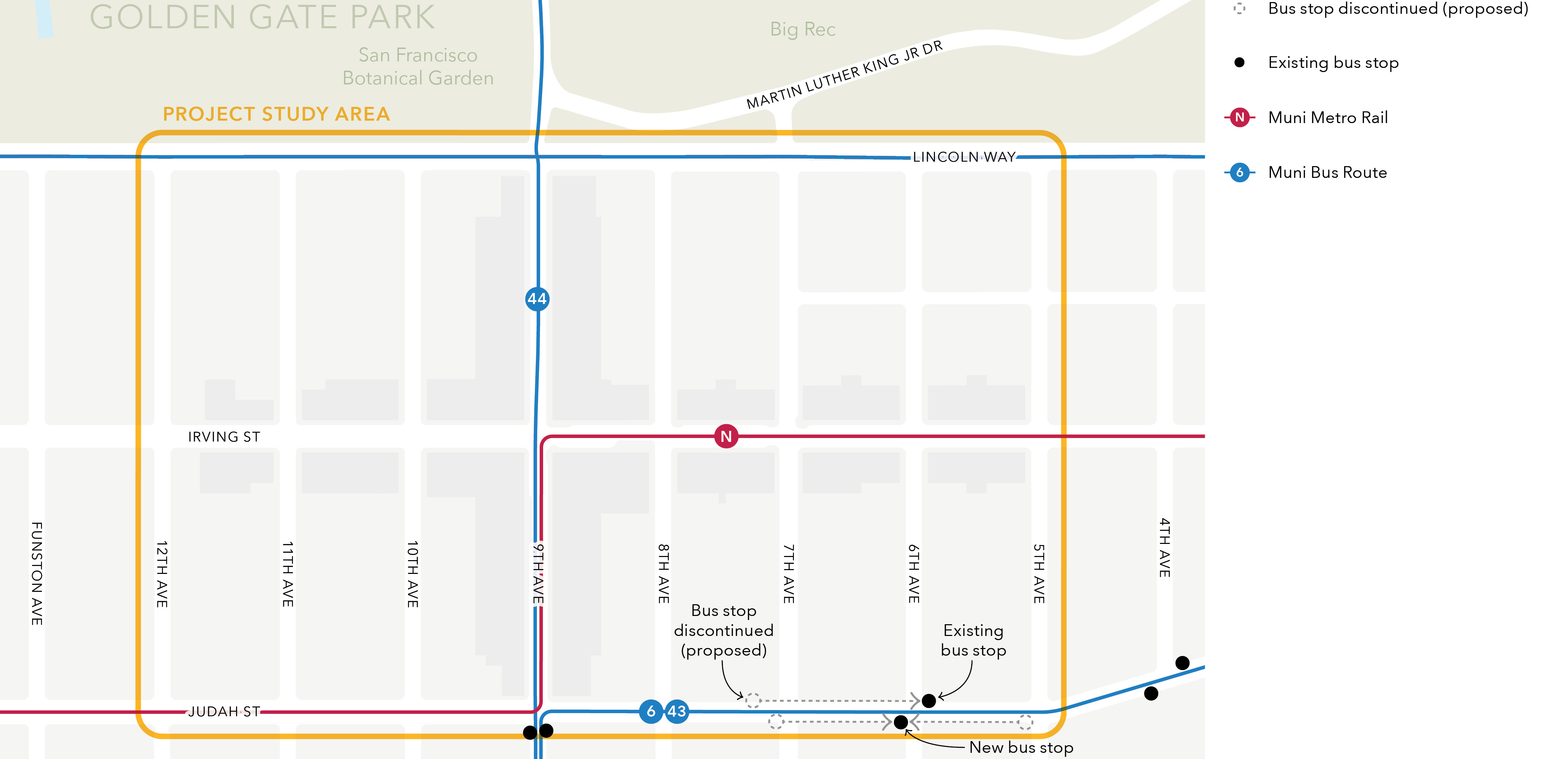
Consolidating transit stops for the 6 Hayes/Parnassus and 43 Masonic routes along Judah Street between 7th and 5th Avenues would improve accessibility and pedestrian visibility while reducing bus travel and dwell times by aligning stop locations with corner curb extensions (bulb-outs) and the SFMTA’s recommended stop spacing guidelines.
The westbound transit stop at 7th Avenue and Judah Street would be removed. Riders could use the nearby stop at 6th Avenue where there is a bus shelter and wider sidewalk space, also known as a curb extension or bulb-out. Removing the westbound stop at 7th Avenue would increase stop spacing in this direction to 1100 feet, within the SFMTA’s recommended stop spacing of 800 to 1360 feet. The eastbound 7th and 5th Avenues stops on Judah Street would consolidate to a new stop at 6th Avenue where there is a bench and wider sidewalk space. With the new stop at 6th Avenue, buses would no longer stop at the near side of a signal at 7th Avenue, allowing them to continue through green lights. The new stop would be located at the near side of an all-way stop sign, reducing the total number of times the bus stops.
This improvement received support from over 65 percent of respondents during outreach. The main reason for opposition against this improvement was the removal of bus stops on Judah Street at 7th Avenue. There were also suggestions for additional stop consolidation on the N Judah at Funston and 12th Avenues.
The changes proposed for this concept may create the opportunity to add parking in place of the relocated stops. Figure 3-3 shows the consolidation of transit stops on Judah Street.
These are conceptual designs for improvements that could move forward for further planning and construction in two to five years. Additional community input opportunities would be available as designs and specifics develop.
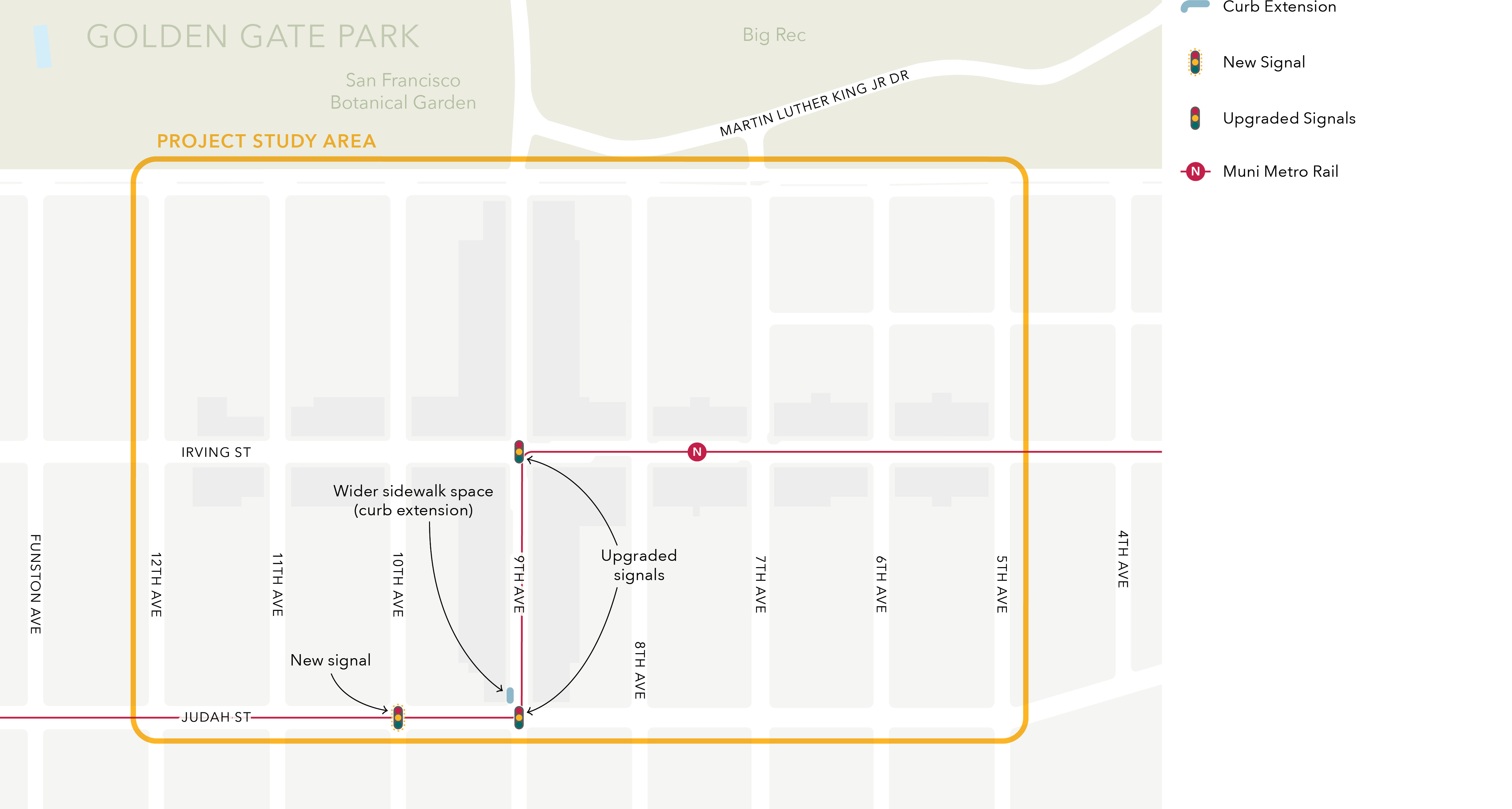
Improvements to the N Judah route to enhance the experience of riding and getting on the train.
This concept received the most support out of all mid-term improvements, with over 75 percent of respondents in support. Respondents who supported the improvement emphasized the need for transit priority for the N Judah. Respondents who opposed the improvement were concerned about the upgrade from a four-way stop sign to a traffic light at 10th Avenue and Judah Street.
Some respondents also expressed concern that the corner bulb-out would take away on-street parking. However, these improvements would not remove or alter any existing parking spaces. Final confirmation of changes at 9th Avenue and Judah Street will require further analysis and engineering.
Figure 3-4 shows the suite of improvements proposed to enhance the travel experience for N Judah riders.
Improvements to the 7 Haight/Noriega route would reduce travel time and improve the experience riding and getting on the bus.
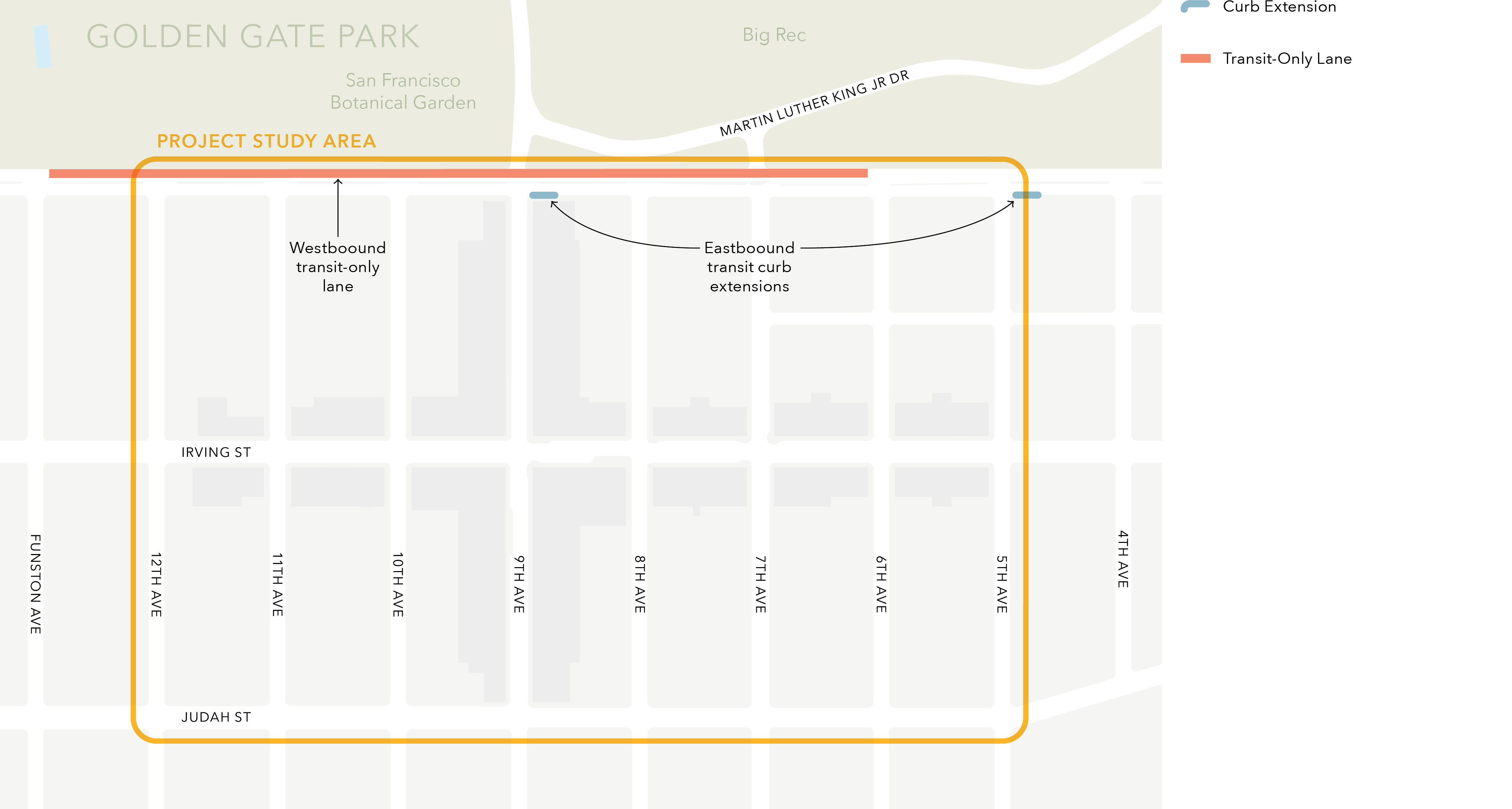
The existing westbound no-parking lane in effect from 3 – 7 p.m. on weekdays along Lincoln Way from 6th Avenue to Funston Avenue would be converted to a bus-only lane. This could save up to a minute for bus riders traveling towards Ocean Beach. Drivers may experience up to 20 seconds of additional travel time from 6th Avenue to Funston Avenue.
The sidewalk would be widened into a curb extension or bulb-out at the southeast corners of Lincoln Way and 5th Avenue in front of San Francisco Elim Church and Lincoln Way and 9th Avenue in front of Pacific Catch. This would improve the pedestrian and transit rider boarding experience, as well as improve travel time for the bus by reducing dwell and merge times.
This improvement received support from over 65 percent of respondents. Respondents suggested extending the hours for which the transit-only lane would be in effect to 24 hours every day and painting the lane red. Some respondents were concerned about the proposed changes increasing vehicular congestion; the conclusion from the Traffic Analysis section below indicates that a westbound transit-only lane on Lincoln Way from 6th Avenue to Funston Avenue would only increase vehicular travel time by up to 20 seconds.
These improvements would not remove or alter any existing parking spaces. Figure 3-5 shows the locations of improvements along Lincoln Way for enhancing travel times for the bus.
A quantitative traffic analysis was conducted to evaluate the impact of the proposed westbound transit-only lane on Lincoln Way from 6th Avenue to Funston Avenue. Table 3-1, Table 3-2, and Table 3-3 summarize the PM peak-hour approach delay (seconds/vehicle) and approach Level of Service (LOS) for each study intersection.
With the proposed transit-only lane, westbound drivers on Lincoln Way may experience up to 20 seconds of additional travel time from 6th Avenue to Funston Avenue.
The 7th Avenue bikeway currently shares space with mixed traffic between Judah Street and Lincoln Way. Upgrades to this segment would define space for people riding bikes and people driving cars, reducing conflicts and improving safety and travel time. This stretch of 7th Avenue is identified in the Biking and Rolling Plan as part of the city’s future “North Star Network,” which is safe and connected network within one-quarter mile of everyone for all ages and abilities.
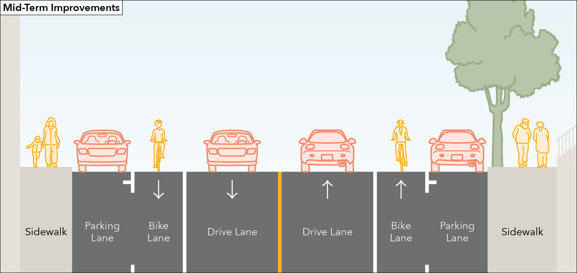
The mid-term improvement would be to upgrade the 7th Avenue bikeway to be painted without protection. This upgrade would require the removal of the center turn lane and potentially the removal of some parking at intersections to improve sightlines for different modes or to maintain left turn pockets. This concept still requires further study, community input, and design.
This improvement received support from nearly 60 percent of respondents. Community members were concerned that a painted bike lane on 7th Avenue would not be sufficient in improving the safety and comfort of biking and rolling through the neighborhood. Respondents who opposed the improvement entirely wanted to maintain the center turn lane on 7th Avenue, particularly at intersections, and expressed that the street is too busy for bicycles. Some respondents suggested potential bicycle facility improvements on Irving Street and others were interested in improving bicycle facilities on 5th and 6th Avenues as alternative bicycle routes to 7th Avenue.
Figure 3-6 shows the mid-block cross-section of an upgraded 7th Avenue with a painted bike lane.
Long-term concepts are not proposals for implementation, but rather for the additional study of transformative street changes that could make major improvements to safety, access, and transit dependability. These changes would require coordination across many agencies, significant additional outreach, community engagement, and additional funds.
Community engagement confirmed a desire to improve north-south bicycle connectivity between Golden Gate Park, the Inner Sunset and points south, but there was little consensus on which streets to focus on and what type of facility to implement. The mid-term painted bike lane upgrade on 7th Avenue received support but does not provide the ultimate low stress, all ages and abilities appropriate connection desired by people riding bicycles. Many, but not all people support the idea of protected bike lanes on 7th Avenue. An alternative route wiggling through 5th Avenue and 6th Avenue was raised by community members as an option with lower vehicle traffic, and though 5th and 6th Avenues do have some bicycle facilities, they are not on the designated bicycle network. This alternate route received support, but would require the additional planning and community collaboration anticipated for this recommended follow-up study. These and other alternatives would be studied to inform decisions about how best to establish a strong bicycle connection linking the Inner Sunset and the Park, considering a full set of options and routes across 7th, 6th and 5th Avenues.
Parking and loading in the Inner Sunset neighborhood can be challenging for residents, businesses, employees, and visitors. SFMTA implemented changes to improve parking and loading supply in 2021, however with increased deliveries and parklets, additional study is warranted. There are solutions that could be explored as part of a larger study to improve parking and loading access, manage parking demand, reduce double parking, and better match people’s needs with the types of parking and loading spaces supplied.
Some examples of strategies that could be considered are:
This improvement received support from over 65 percent of respondents during outreach. Many respondents indicated that scooters and delivery vehicles would often block on-street parking spaces and through traffic. Some respondents would like the study to examine potential solutions for reducing double parking and providing more parking spaces. Local merchants were concerned that the lack of parking in the neighborhood contributed to the increased traffic congestion and lack of customers in the area.
However, the availability of parking spaces has neither reduced nor increased in recent years. The increase in traffic congestion may be attributed to an increase in the number of people accessing the neighborhood and increased demand for commercial loading space because of increased delivery service activity. The study would explore policies for shorter-term parking across existing parking spaces to induce higher turnover rates and increase the number of customers accessing local businesses as well as considering the reallocation of curb space to better match with current curb demands and improve curb efficiency.
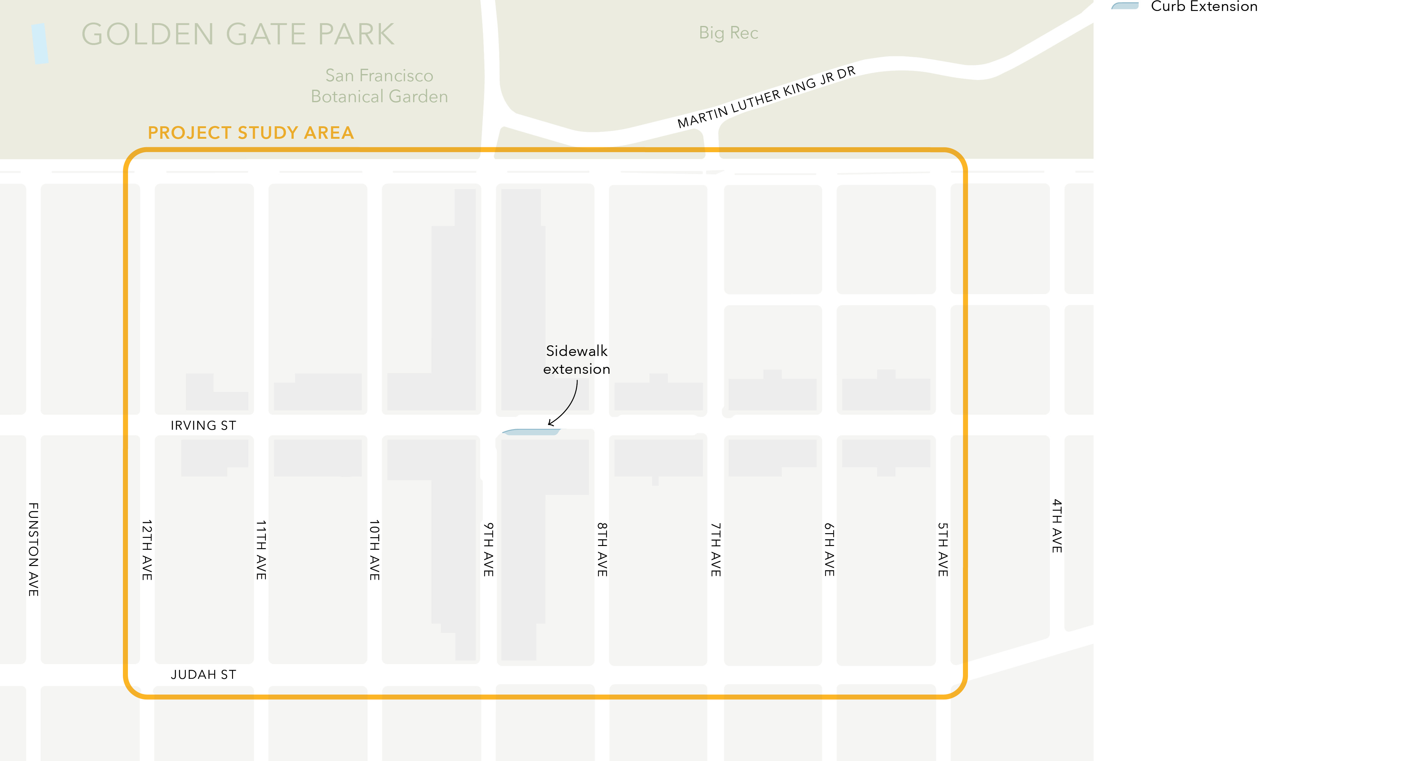
In collaboration with merchants, explore and design a streetscape project that would expand the sidewalk on Irving Street between 8th and 9th Avenue, similar to the parklet in front of Arizmendi Bakery on the 1300 block of 9th Avenue. This would improve public space, safety, and prevent double-parking along the N Judah.
Planters could be placed at the southeast corner of the intersection in the near term. Additional spaces to sit and meet could enhance the experience for people visiting the neighborhood. These improvements would not remove or alter any existing parking spaces. Efforts like this would need to be advanced in coordination with the San Francisco Planning Department and Department of Public Works.
This improvement received support from about 70 percent of respondents during outreach. Most respondents agreed that parklets and pedestrian space were important for the community as long as those spaces did not hinder driving through the area. Some respondents suggested the need to improve the circulation of delivery vehicles and reduce conflicts between delivery vehicles and pedestrians and other road users.
Figure 3-7 shows the location of the proposed long-term public space improvement in the study area.
Community members suggested ideas in addition to the proposed improvements. These concepts are not being advanced at this time, but could be revisited again in the future.
One such idea was implementing a pedestrian scramble at the intersection of 9th Avenue and Lincoln Way. Pedestrian scrambles eliminate conflicts between pedestrians and turning vehicles by creating an all-direction pedestrian-only phase. With existing left-turn and no-turn-on-red restrictions at the intersection, a pedestrian scramble may not be the most appropriate solution.
The study team conducted an analysis of the typical criteria for implementation of a pedestrian scramble, and found that the intersection of 9th Avenue and Lincoln Way could meet some, but not all criteria. A scramble would also introduce tradeoffs, such as increased delay and waiting time for people on transit, people driving, and people walking and rolling, given the longer cycle times required to include a new all-pedestrian phase. Instead of advancing a scramble, the short-term improvement of making it easier for drivers to see people (Concept 1) includes a painted safety zone at the southwest corner of the intersection. Similarly, the mid-term improvement of making the 7 Haight/Parnassus bus route more reliable (Concept 5) proposes a corner bulb-out at the southeast corner of the intersection. Both proposed improvements would achieve higher pedestrian visibility and easier crossings.
Many community members supported the idea of pedestrianizing Irving Street. The long-term improvement of allocating more public space for people on Irving Street (Concept 9) would align with this idea and would involve a longer-term process of concept development and evaluation. Many of the concepts in this report are intended to make the Inner Sunset more comfortable for people walking. The desire to fully pedestrianize street space could be revisited after these improvements are completed. This process would need to be led by the San Francisco Planning Department as a public realm and urban design project, with collaboration from SFMTA and Public Works.
Another idea was implementing left-turn restrictions at select locations throughout the study area to reduce conflicting movements and delays caused by left turning vehicles to transit and other traffic. The study team conducted a traffic analysis and concluded that left-turn restrictions would only redirect vehicles to nearby intersections and not improve safety or traffic congestion overall. The short-term improvement of updating driving directions (Concept 2) would encourage drivers on Lincoln Way to turn left at intersections with traffic lights to improve traffic flow.
Lastly, a curb management study was suggested to explore solutions to induce parking turnover and ease pick-up and delivery trips. The long-term recommendation to conduct a parking access study (Concept 8) would also address similar goals. The study would aim to address parking and loading demand while maintaining pedestrian-friendly features.
Phase 2 of community outreach included an in-person Town Hall meeting, an online survey, and several pop-up events. About 80 people attended the in-person event, about 230 people filled out the survey, and about 180 responses were received across the pop-up events. The feedback received is summarized in each of the concept sections above.
A second in-person Town Hall meeting was held at the San Francisco County Fair Building where community members were invited to share their thoughts on draft concepts. The presentation included a summary of takeaways from Phase 1 community outreach, the main priorities for safety and circulation improvements based on those takeaways as well as documented existing conditions, and a list of draft concepts. Interactive boards were provided where each board represented a draft concept. Feedback was gathered at these boards where attendees were invited to provide feedback through discussions, stickers, and comment cards. Attendees could use stickers and comment cards to indicate whether they supported or opposed the draft concept at each board.
Similar to Phase 1, community members had access to an online survey on the project’s website. Throughout October, the survey was open to the public for comments on the draft concepts.
Pop-up events were held at various locations within and around the study area to capture a wide demographic range of the local population. These locations included: the bus stop in front of the seafood restaurant, Pacific Catch, at 9th Avenue and Lincoln Way; the 22nd and Irving Market; and the Inner Sunset Flea Market.
Members of the study team met with owners or managers of businesses that front the location of proposed specific improvements on Irving, Judah, Parnassus, and 9th Ave. These business owners and managers were generally in agreement with the issues and challenges presented, and supportive of the concepts.
The study team finalized project concepts based on community feedback, technical feasibility, and alignment with the goals of the Study along with citywide plans and policies. Finalized project concepts are recommendations that can be advanced for implementation or study, as appropriate, and are expected to prioritize safety for vulnerable road users, improve transit reliability, enhance connectivity to key local destinations, and support economic vitality in the study area.
As a result of outreach and coordination with District 7 Supervisor Myrna Melgar’s office, Concept 6 — An Upgraded 7th Avenue Bike Lane is recommended to advance from mid-term to near-term, and Concept 7 — Closing the Gap in Bicycle Facilities From 7th Ave & Lawton to Golden Gate Park is recommended to advance from long-term to mid-term. Additionally, the study recommends the expansion of Concept 9 — Study: More Public Space for People on Irving Street be expanded to include the development of potential concepts for both sides of Irving St from 5th Avenue to 9th Avenue.
The recommendations for the Study are summarized below. For additional descriptions of each concept, please refer to Section 3 of this report. Concept numbers in Section 3 correspond with Recommendation numbers in this chapter for clarity and continuity. Because of the timeframe changes described above, some recommendations no longer appear in the original numerical order below.
Implement pedestrian safety improvements across the study area. There are three different types of improvements that can be implemented to increase visibility for people crossing the intersection:
Refer to Figure 3-2 for a map of potential locations and types of pedestrian safety improvements within the study area.
Suggest updates to mapping companies’ directions (e.g. Google, Apple, etc.) to improve traffic circulation and reduce congestion. Recommendations for community-driven, improved directions would be sent to mapping apps (e.g. Google Maps, Apple Maps, Waze, etc.) so they could route people in the most effective way. The re-routing would not impact existing streets or sidewalks.
Accessing the DeYoung Museum, Music Concourse Garage, and nearby sites can cause traffic backups partly because some vehicles on the north side of the park are routed to drive around the park and enter near 9th Avenue and Lincoln Way. Updated directions would suggest that drivers coming from the north side of the park enter the park southbound on 10th Avenue at Fulton Street.
Westbound vehicles turning left from Lincoln Way onto 8th Avenue can cause traffic jams. Updated directions would suggest that drivers on Lincoln Way turn left at intersections with traffic lights to improve traffic flow.
Transit stops for the 6 Hayes/Parnassus and 43 Masonic routes would be consolidated to improve accessibility and pedestrian visibility while reducing bus travel and dwell times.
The westbound transit stop at 7th Avenue and Judah Street would be removed. Riders could use the nearby stop at 6th Avenue where there is a bus shelter and wider sidewalk space, also known as a curb extension or bulb-out. The eastbound 7th and 5th Avenues stops on Judah Street would consolidate to a new stop at 6th Avenue where there is a bench and wider sidewalk space.
The changes proposed for this concept may create the opportunity to add parking in place of the relocated stops. Refer to Figure 3-3 for the consolidation of transit stops on Judah Street.
The 7th Avenue bikeway currently shares space with mixed traffic between Judah Street and Lincoln Way. Upgrades to this segment would define space for people riding bikes and people driving cars, reducing conflicts and improving safety and travel time. This stretch of 7th Avenue is identified in the Biking and Rolling Plan as part of the city’s “North Star Network.”
The mid-term improvement would be to upgrade the 7th Avenue bikeway to be painted without protection. This upgrade would require the removal of the center turn lane. This concept still requires further study, community input, and design.
Refer to Figure 3-6 for the cross-section of an upgraded 7th Avenue with a painted bike lane.
Improvements to the N Judah route to enhance the experience of riding and getting on the train.
These improvements would not remove or alter any existing parking spaces. Final confirmation of changes at 9th Avenue and Judah Street will require further analysis and engineering.
Refer to Figure 3-4 for the suite of improvements planned to enhance the travel experience for N Judah riders.
Improvements to the 7 Haight/Noriega route would reduce travel time and improve the experience riding and getting on the bus.
The existing westbound no-parking lane in effect from 3 – 7 p.m. on weekdays along Lincoln Way from 6th Avenue to Funston Avenue would be converted to a bus-only lane. This could save up to a minute for bus riders traveling towards Ocean Beach. Drivers may experience up to 20 seconds of additional travel time from 6th Avenue to Funston Avenue. Refer to Table 3-1, Table 3-2, and Table 3-3 for the traffic analysis on expected vehicle delay resulting from the introduction of a part-time bus-only lane.
The sidewalk would be widened into a curb extension or bulb-out at the southeast corners of Lincoln Way and 5th Avenue in front of San Francisco Elim Church and Lincoln Way and 9th Avenue in front of Pacific Catch. This would improve the pedestrian and transit rider boarding experience, as well as improve travel time for the bus.
These improvements would not remove or alter any existing parking spaces. Refer to Figure 3-5 for the locations of improvements along Lincoln Way for enhancing travel times for the bus.
Explore the feasibility of improving bicycle facilities on 5thth, 6thth, and 7thth Avenues or other nearby streets to establish a strong bicycle connection linking Golden Gate Park, the Inner Sunset, and points south. Starting with the recommendations of the Biking and Rolling Plan, this study would include an exploration of specific routes and facilities, including conceptual design, and outreach with community members, travelers, businesses, and travelers. The result would be a recommendation for implementation and a funding plan to do so.
There are solutions that could be explored as part of a larger study to improve parking access, manage parking demand, and better match people’s needs with the types of parking supplied.
Some examples of strategies that could be considered are:
In collaboration with merchants, explore and design a streetscape project that would expand the sidewalk on Irving Street between 5th and 9th Avenue, similar to the parklet in front of Arizmendi Bakery on the 1300 block of 9th Avenue. This would improve public space, safety, and prevent double-parking along the N Judah.
Planters could be placed to expand pedestrian space in the near term. Additional spaces to sit and meet could enhance the experience for people visiting the neighborhood. Consideration of these improvements should be advanced in parallel with Recommendation 8 — Study: Improving Parking Access to ensure adequate provisions are made for parking, delivery, and loading throughout the neighborhood.
Refer to Figure 3-7 for the location of the proposed long-term public space improvement in the study area.
The project team developed preliminary, concept level cost estimates for the design and implementation of near-term, mid-term, and long-term recommendations. The preliminary cost estimates for each recommendation are summarized in the table below.
At the time of this report, the near-term recommendation to upgrade the 7th Avenue bike lane is the only recommendation with funding for implementation already secured. This project will be supported with $150,000 in previously programmed Prop L sales tax funds from the Safer and Complete Streets Program on reserve for design and implementation. The SFMTA may request that the Transportation Authority Board allocate these funds for the scope of work proposed below.
Recommendations 3, 4, and 5, detailed below, are intended to advance as part of broader SFMTA projects and would require further outreach and planning.
The remaining recommendations are standalone projectsAs recommendations proceed through further outreach, planning, and development, it may be beneficial to combine certain recommendations into a single project to make them more competitive for certain funding sources. and do not currently have funding sources in hand for implementation. While recommendations 3, 4, and 5 may be funded as a part of larger SFMTA projects, these improvements may require additional funding sources. As such, the project team has identified potential funding sources for project recommendations, summarized in Table 4-1 below, with further information about funding sources and strategies in Section 4.3.
In this section we provide a brief description of some potential funding sources for the Study recommendations, including those listed in Table 4-1 in the prior section. Based on our current knowledge of funding sources, we’ve provided an illustrative list of the most likely sources for each recommendation. It is worth noting that in the transportation sector, there is chronically far more demand and need for funding than available revenues, making many fund sources highly competitive. Further most programs have funding guidelines that determine eligible project sponsors and project types, prioritization criteria, and other requirements that collectively help determine which projects are most likely to be successful in securing funding from that source. For example, many fund sources require a certain amount of matching funds. Other sources may give more points or priority to projects that benefit an Equity Priority Community or disadvantaged population or that come from a community-based planning effort. Funding guidelines are subject to change and should be reviewed before considering whether a project is a good match for that particular source and to understand the timing of when funds may be available for new projects.
Proposition AA is a voter-approved $10 annual vehicle registration fee that funds local street repair and reconstruction, pedestrian and bicycle safety improvements, and transit reliability and mobility improvements throughout San Francisco. Given its small size — less than $5 million in revenue per year — Prop AA is used to support small, high-impact projects that provide tangible benefits to the public in the short term, and only funds design and construction phases of projects.
Prop AA projects are split into three categories:
Prop AA could fund the design and construction phases for projects that include pedestrian improvements and transit reliability and mobility enhancements.
The Proposition D Traffic Congestion Mitigation Tax (TNC Tax) was passed by San Francisco voters in 2019. The City imposes the TNC Tax (effective January 1, 2020) of 1.5% to 3.25% on fares for rides originating in San Francisco, for the portion of the trip within the city, that are facilitated by commercial ride share companies or are provided by an autonomous vehicle or private transit services vehicle. The Transportation Authority’s share of 50% of TNC Tax revenues, estimated at $9.8 million for Fiscal Year 2026/27, are available for street safety projects including pedestrian or bicycle safety projects, traffic calming, and traffic signal upgrades and re-timing.
In 2022, San Francisco voters approved Proposition L (Prop L), the Sales Tax for Transportation, which directs half-cent sales tax funds to a 30-year Expenditure Plan that describes the types of projects eligible for funds under each of its 28 programs. The Study recommends an upgraded 7th Avenue bike lane, which has $150,000 programmed under the Safer and Complete Streets program for design and construction of the bikeway. Recommendations from this Study that prioritize safety for vulnerable road users, improve transit reliability, enhance connectivity to key local destinations are eligible for one or more Prop L programs below:
SFCTA’s Neighborhood Program funds neighborhood-scale transportation projects in each supervisorial district to address locally identified mobility needs. The program prioritizes initiatives that improve safety for people walking and biking, encourage sustainable travel modes, enhance transit access and reliability, and advance mobility in Equity Priority Communities and other underserved areas. Each supervisorial district is granted $700,000 in Prop L sales tax funds over a five-year period, and funds can support both planning and capital projects. Project selection is guided by district supervisors based on community input and stakeholder engagement. As such, any of the project’s recommendations may be appropriate for future Neighborhood Program funding.
Some discretionary funding may be available within the General Fund budgeting process for the types of recommendations included in this plan.
While SFMTA is facing very constrained financial resources at present, if the financial outlook improves, SFMTA may have flexible funding such as revenues from the Prop B General Fund Set Aside that could be used to support the types of recommendations included in this Study.
The state Department of Transportation (Caltrans) provides grants to encourage increased use of active modes of transportation. This highly competitive program could fund the type of bike and pedestrian safety infrastructure recommendations that stem from future studies, but the program emphasizes projects that benefit disadvantaged communities, in addition to those that measurably increase walking and biking. Only projects requesting more than $250,000 are eligible. As the recommended mid-term bicycle connection work progresses, this source may be considered if there are clear benefits to disadvantaged communities.
The California Office of Traffic Safety Grant Program offers grants for a variety of priority program areas, including pedestrian and bicycle safety. This program places emphasis on high-risk populations, therefore any project recommendations eligible for this funding would benefit from demonstrating how pedestrian and bicycle improvements would increase safety for vulnerable populations.
The Metropolitan Transportation Commission’s (MTC) Community Action Resource and Empowerment (CARE) Program provides $22 million to support community-prioritized transportation initiatives developed through engagement and power-building efforts, and provides capacity building and technical assistance to community-based organizations and local governments. As such, the program is divided into three program areas:
Since this project relied on community outreach, reflecting the needs of stakeholders including residents, merchants, workers, visitors, and local community organizations, study recommendations may be eligible for CARE program funding under the Community Based Transportation Plan Project Development or Coordinated Plan strategy focus area. Project recommendations that include sidewalk improvements at or near transit stops, safety or modernization improvements, bicycle and pedestrian projects, bus stop improvements, accessibility enhancements, streetscape improvements, and transit access improvements for disadvantaged communities are all eligible capital projects for the CARE program’s Community Based Transportation Plan Project Development or Coordinated Plan strategy focus area. The Care program gives priority to, among other things, projects that directly address transportation gaps and/or barriers identified through community-based planning process or other planning efforts that involved focused inclusive engagement to low-income populations.
The Highway Safety Improvement Program (HSIP) is one of the core federal-aid programs to states. The purpose of the HSIP program is to achieve a significant reduction in traffic fatalities and serious injuries on all public roads, including non-State-owned public roads and roads on tribal land. Example safety projects include crosswalk markings, rapid flashing beacons, curb extensions, speed feedback signs, median islands, and other pavement markings. In California, HSIP prioritizes projects based on a benefit-to-cost ratio. Projects along roadways with a relatively high crash history (e.g., 9th/ Lincoln) may be able to achieve a competitive benefit-to-cost ratio and be funded through HSIP.
MTC’s Innovative Deployments to Enhance Arterials (IDEA) grant program funds transit signal priority projects along major arterial roadways to improve transit speed and reliability. This study recommends both new and upgraded signals to provide more reliable travel for N Judah, which may be eligible for IDEA grant funding.
In prior years, MTC has solicited proposals for Local Parking Management Program Planning Grants, which support the development of parking management plans and related planning activities needed to advance projects aligned with Plan Bay Area 2050. The last call for projects was released in February 2023, so it is unclear if and when MTC will release a new call for projects. However, any future Local Parking Management Program Planning Grant program may be a potential funding source for this study’s recommendation to conduct a parking access study.
The Local Partnership Program, administered by the California Transportation Commission (CTC), offers $200 million annually to local and regional transportation agencies. 40% of funds are distributed through a competitive program and 60% are distributed through a formulaic program. Jurisdictions and agencies with voter approved taxes, tolls, or fees, that are dedicated solely to transportation improvements are eligible to apply. In San Francisco both the City and County of San Francisco (through the Prop D TNC Tax) and the SFCTA (through Prop L and Prop AA) are eligible to apply and/or nominate projects for funding. LPP projects must provide a one-to-one match using private, local, federal, or state funds. Relevant eligible projects include:
MTC’s Priority Conservation Area (PCA) Grants provide funding for local projects that support conservation efforts in the Bay Area. PCAs are spaces that have outdoor recreation or environmental benefits in the Bay Area. This program offers a wide range of grant awards, with the most recent call for projects providing grants from $200,000 to $1 million. Relevant eligible project types are planning activities, including public access to open space and parklands, and pedestrian and bicycle facilities. Within the study area, Golden Gate Park, 5th Avenue between Lincoln Way and Parnassus Avenue, and the land adjacent to Mount Sutro Open Space Reserve (specifically south of Parnassus Avenue, bound by 5th Avenue to the east), are identified as PCAs. This may be a viable fund source for the Inner Sunset – Golden Gate Park Bicycle Connection recommendation.
Through the Infrastructure Investments and Jobs Act, USDOT provides funding for several types of projects, including funding for active transportation projects and programs. One program, the Safe Streets for All (SS4A) Grant Program, can fund bike safety improvements.
MTC’s Transit Performance Initiative Investment Program is a competitive grant program for capital projects, with funds available from the state Low Carbon Transit Operations Program. This program funds lower-cost, near-term capital improvements that enhance operations along high-frequency bus corridors and at key connections between high-frequency or high-ridership transit services. Project recommendations that would provide more reliable travel on high-frequency or high-ridership transit lines may be eligible for funding.
The Inner Sunset Transportation Study was funded by the San Francisco County Transportation Authority’s Neighborhood Program at the request of District 7 Commissioner and Transportation Authority Board Chair Myrna Melgar. The Neighborhood Program was established to fund community-based efforts in San Francisco neighborhoods, especially in underserved neighborhoods and areas with vulnerable populations (e.g., seniors, children, and/or people with disabilities). The Neighborhood Program is made possible with San Francisco’s half-cent sales tax for transportation funds.

 Download a PDF of this report